
Northern California forecast: Few light showers possible Sunday
Saturday night will be dry but cloudy for most of the region, but a second wave of moisture will arrive early Sunday morning.
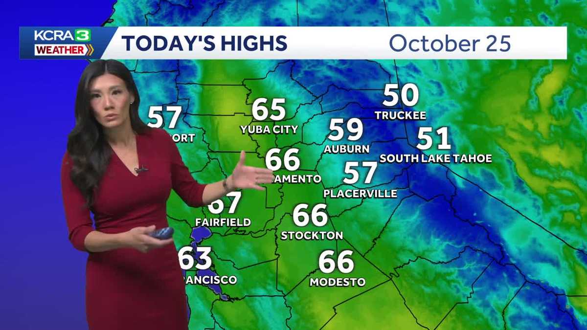
AND WE WANT TO GET STRAIGHT OVER TO METEOROLOGIST OPHELIA YOUNG OPHELIA YOUNG. YOU AND I WERE TALKING ABOUT THIS EARLIER. THIS IS JUST SUCH AN INCREDIBLY POWERFUL STORM SYSTEM ABOUT TO HIT LANDFALL. YES, A VERY SCARY SITUATION FOR JAMAICA RIGHT NOW. WHEN WE WOKE UP THIS MORNING, MELANIE, HURRICANE MELISSA WAS STILL A TROPICAL STORM. FROM THIS MORNING UNTIL NOW, IT HAS QUICKLY INTENSIFIED TO A CATEGORY THREE WITH WINDS 115MPH SUSTAINED. AND HERE’S WHY. HERE’S A MAP OF OUR SEA SURFACE TEMPERATURES. YOU SEE THAT PINK THAT IS HUGGING MEXICO, THE CARIBBEAN, STRETCHING ALL THE WAY OUT INTO AFRICA? THESE ARE SOME OF THE WARMEST SEA SURFACE TEMPERATURES, SOME OF THE WARMEST OCEAN WATERS. AND HURRICANE MELISSA IS SITTING RIGHT IN THE MIDDLE OF IT. SO YES, HURRICANE MELISSA IS EXPECTED TO KEEP STRENGTHENING TO A CATEGORY FOUR, MAYBE EVEN A FIVE AS IT HITS JAMAICA. THAT WILL BE EARLY TUESDAY MORNING. THEIR TIME. AND THIS IS WHY THIS IS A WORST CASE SCENARIO FOR JAMAICA IS BECAUSE KINGSTON, WHICH IS THE MOST POPULATED CITY OF JAMAICA, WILL BE SITTING IN THE FRONT RIGHT QUADRANT OF THE HURRICANE, WHICH IS ALSO KNOWN AS THE DIRTY SIDE OF THE HURRICANE. THEY’RE ALREADY GETTING RAIN AND SATURATED GROUND RIGHT NOW. FROM NOW UNTIL TUESDAY, THE END OF TUESDAY, WE’RE LOOKING AT 2 TO 3FT OF RAIN. THIS IS CATASTROPHIC AMOUNTS OF RAIN PAIRED WITH DESTRUCTIVE WINDS. I ONLY WISH WE COULD BRING SOME OF THAT RAIN BACK HERE TO THE WEST COAST, BECAUSE WE DID HAVE A SYSTEM MOVE THROUGH, AND WE GOT ALMOST NOTHING FROM IT HERE IN THE VALLEY. TRACE AMOUNTS FROM YUBA CITY. SACRAMENTO MODESTO STOCKTON. ONLY A FEW HUNDREDTHS OF AN INCH. AUBURN AND PLACERVILLE ALSO A FEW HUNDREDTHS TRUCKEE AND SOUTH LAKE TAHOE. NOT MUCH BETTER. THOSE ARE OUR MAIN OBSERVATIONS. STATION. THIS IS OTHER WEATHER STATIONS SAYING SACRAMENTO EXECUTIVE OR INTERNATIONAL AIRPORT DID GET A FEW HUNDRED SOMETHING MEASURABLE. HOMEWOOD UP IN THE SIERRA QUARTER INCH IN POLLOCK PINES MORE THAN A 10TH GRASS VALLEY IN BLUE CANYON, ABOUT A THIRD OF AN INCH. SO NOT TOO BAD FOR SOME SELECT AREAS, BUT FOR MOST, IT WAS JUST MISTY. MAYBE A FEW DROPS OF RAIN, MOSTLY CLOUDY AND COOLER TEMPERATURES IN THE MID 60S IN THE VALLEY. WE HAD UPPER 50S IN THE FOOTHILLS WITH TRUCKEE AND SOUTH LAKE TAHOE. THEIR TOP TEMPERATURES TODAY ONLY IN THE LOW 50S. THEY ALSO HAD SOME WINDS. LOOKS LIKE THIS LATE EVENING. STILL HOLDING ON TO THOSE WINDY CONDITIONS IN SOUTH LAKE TAHOE. THERE SUSTAINED WINDS ABOUT 22MPH. SO AS YOU CAN TELL, MOST OF WHAT CAME THROUGH HERE WERE JUST CLOUDS AND A FEW DROPS OF RAIN. SOME WIND. RIGHT NOW WE’RE STILL TRACKING A FEW SHOWERS JUST SOUTHWEST OF QUINCY AND A BLIP OF RAIN YOU SEE THERE FROM RIO VISTA OUT TO FAIRFIELD. BUT FOR THE MOST PART, WE’RE IN A DRY WINDOW. WE ARE ANTICIPATING A SECOND ROUND OF SHOWERS THAT’S MOVING ONSHORE RIGHT NOW, AND THAT SHOULD ARRIVE EARLY TOMORROW MORNING WITH SHOWERS FIRST THROUGH YUBA CITY, AND THEN IT WILL CRAWL INTO THE SIERRA DOWN SOUTH, WHERE SNOW LEVELS WILL BE DROPPED TO ABOUT 7000FT. AND THEN THE SHOWERS WILL GRADUALLY GET SPOTTIER AND SPOTTIER THROUGH THE DAY UNTIL WE’RE DRY BY DINNERTIME. AND THEN WE’RE LOOKING FORWARD TO A BEAUTIFUL REST OF THE WEEK. WE ALSO GOT SOME SHOWERS IN THE WEST, OR WIND RATHER IN THE WEST VALLEY, AND ALSO SOME STRONGER WINDS IN THE SIERRA. THEY’LL BE UNDER A WIND ADVISORY ONCE AGAIN FOR GUSTS UP TO 50MPH, UP TO 100MPH IN THE VERY, VERY RIDGES. WAVE HEIGHTS 2 TO 5FT HIGH. SO NOT A GOOD DAY TO GO BOATING IN THE SIERRA HERE IN THE VALLEY. 64 DEGREES WILL BE COOL TOMORROW WITH A FEW SHOWERS. TEMPERATURES WILL GRADUALLY WORK THEIR WAY BACK INTO THE 70S.
Northern California forecast: Few light showers possible Sunday
Saturday night will be dry but cloudy for most of the region, but a second wave of moisture will arrive early Sunday morning.

Updated: 11:50 PM PDT Oct 25, 2025
Saturday night will be dry but cloudy for most of the region, but a second wave of moisture will arrive early Sunday morning.So far, rain totals have been slim, with the valley seeing only a trace to a few hundredths of an inch; similar amounts have been recorded in the foothills and the Sierra. A few foothill spots, such as Blue Canyon and Grass Valley, have received a bit more.Saturday night will be a window between two waves of moisture. Rain chances increase again early Sunday as precipitation spreads across areas north of Sacramento; Yuba City may see early morning showers. The precipitation will climb into the Sierra from the north and spread south, changing to snow above 7,000 feet.Gusty winds will return to the Sierra, which will once again be under a Wind Advisory for gusts up to 50 mph and wave heights of 2 to 5 feet. Areas in the western valley foothills can also expect strong winds.In the valley and foothills, a few more sprinkles—and perhaps a brief light shower—are possible in the morning, with rain becoming increasingly spotty through the afternoon.The region will be dry by evening. Mild fall weather returns for the week, with valley highs warming into the mid to upper 70s under occasional clouds.
SACRAMENTO, Calif. —
Saturday night will be dry but cloudy for most of the region, but a second wave of moisture will arrive early Sunday morning.
So far, rain totals have been slim, with the valley seeing only a trace to a few hundredths of an inch; similar amounts have been recorded in the foothills and the Sierra. A few foothill spots, such as Blue Canyon and Grass Valley, have received a bit more.
Saturday night will be a window between two waves of moisture. Rain chances increase again early Sunday as precipitation spreads across areas north of Sacramento; Yuba City may see early morning showers. The precipitation will climb into the Sierra from the north and spread south, changing to snow above 7,000 feet.
Gusty winds will return to the Sierra, which will once again be under a Wind Advisory for gusts up to 50 mph and wave heights of 2 to 5 feet. Areas in the western valley foothills can also expect strong winds.
In the valley and foothills, a few more sprinkles—and perhaps a brief light shower—are possible in the morning, with rain becoming increasingly spotty through the afternoon.
The region will be dry by evening. Mild fall weather returns for the week, with valley highs warming into the mid to upper 70s under occasional clouds.