
High temperatures will approach 80 degrees in parts of San Francisco on Friday, continuing a weekslong trend of warmer-than-normal weather.
Baron/Lynx
Bay Area temperatures are forecast to spike again this weekend, wrapping up a month that’s on track to finish as the region’s warmest March on record. In some cities, it will be the most anomalous month of temperatures ever measured.
After a burst of marine air brought a brief midweek cooldown — in a relative sense — winds and temperatures began to reverse course Thursday, a trend that will continue Friday. Light to moderate north-northeasterly winds will erode the marine layer and provide a slight heating effect as they sink off the hills. That’ll push temperatures into the 70s by noon, even in San Francisco and Oakland.
The sea breeze is expected to kick in by midafternoon and prevent downtown San Francisco from hitting 80 degrees, though Oakland could threaten that mark. Santa Rosa, Napa, Walnut Creek, Livermore and San Jose should easily reach the low 80s.
Article continues below this ad
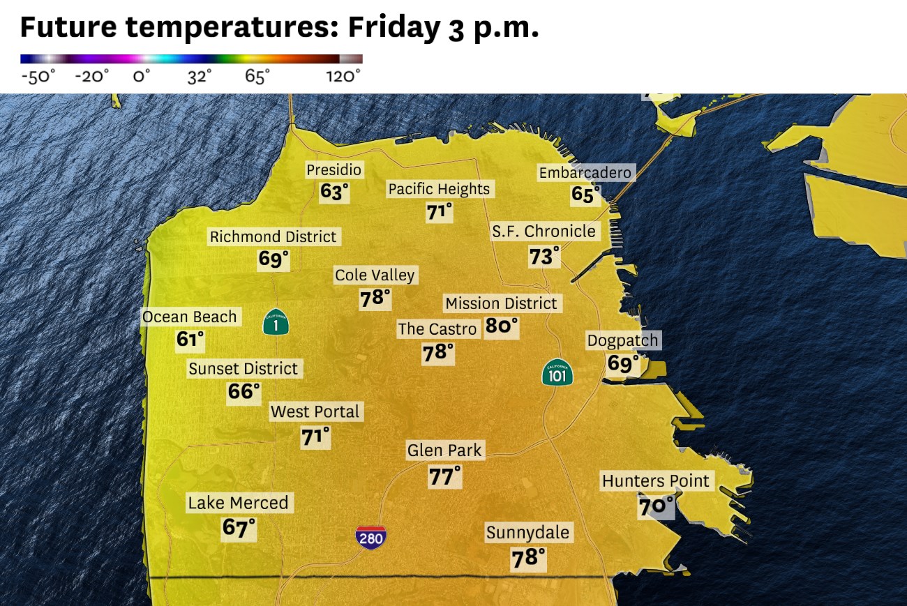
High temperatures Friday will be in the mid-70s to low 80s across the Bay Area, except along the immediate coastline, where they’ll be in the upper 60s to low 70s.
Baron/Lynx
Saturday appears a bit cooler, especially along the coast and bay shoreline due to an earlier arrival of the sea breeze. Inland areas should again reach the low 80s. Sunday may mirror Friday’s patterns, with another warmup in San Francisco, while the interior valleys may climb all the way to the mid-80s.
A few same-day temperature records are possible, particularly Sunday, though highs will still be about 5 to 10 degrees lower than they were last week. Overnight lows will vary dramatically depending on elevation and proximity to the bay or coast, from the low 40s to low 60s.
San Francisco Chronicle Logo
Make us a Preferred Source to get more of our news when you search.
Add Preferred Source
The weekend warmth is bound to push monthly temperature averages even higher. This month is already the warmest March on record in nearly every Bay Area city, including San Francisco and Oakland.
Article continues below this ad
From March 1 to 25, San Francisco’s mean temperature — the average of daytime highs and overnight lows — was 62.6 degrees, 6.2 higher than the 1991-2020 normal. Even more striking, March 2026 was trending warmer than all but one April and two Mays in more than 150 years of city records.
Santa Rosa was on pace to set a March record by more than 4 degrees. It was also warmer than any April by 2 degrees. With well above-normal temperatures forecast this weekend, March 2026 will likely end up as Santa Rosa’s most anomalously warm month in history by a considerable margin.
Monday probably won’t be as warm, though still above March norms. March 31 may be the first and only day of the month with below-normal temperatures across the Bay Area as a wet weather system approaches the region.
Weekend breakdown
San Francisco: Warmer-than-normal weather will continue through the weekend, with no fog. Friday will probably be the warmest day under a mix of sun and clouds. Highs will be in the upper 60s to low 70s west of Twin Peaks and the mid- to upper 70s to the east. A stronger sea breeze Saturday is expected to drop highs by about 5 degrees, but still above March norms. Highs Sunday will be somewhere between Friday’s and Saturday’s, with 60s at the Pacific beaches and plenty of 70s on the bay side. Overnight lows will be in the low 50s.
Article continues below this ad
North Bay: Anomalously warm weather will continue as highs reach the upper 70s to low 80s in Wine Country from Friday through Sunday. The peak of the warmth Sunday may push temperatures as high as the mid-80s in Fairfield and Vacaville. Cooler conditions will prevail along the coast, in the 60s to low 70s, though skies will be clear of fog. Overnight lows will range from the low 40s to low 50s in the valleys to the mid-50s to mid-60s in the hills.
East Bay: Temperatures will be most uniform throughout the East Bay on Friday, in the upper 70s to low 80s. It will mark Oakland’s 21st day of 70 degrees or higher this month, setting a new record for March. Less likely, though possible, is an 80-degree reading, which would be Oakland’s eighth of the month, tying 2004 for the most in March. Overnight lows will be in the mid-40s to low 50s.
Saturday should cool to the low to mid-70s along the bay shoreline while inland areas remain around 80 degrees. Sunday may be the warmest day of the bunch, in the upper 70s to low 80s for the bay shoreline and mid-80s inland. No fog is expected, though there will be a mix of sun and clouds Friday before mainly clear skies Saturday and Sunday. Overnight lows will be in the 50s in the valleys and the low 60s above 1,000 feet.
Pacific Coast and Peninsula: The weekend forecast could be characterized by a Saturday sandwich, a relatively mild day nestled between two unseasonably warm ones. Friday and Sunday will bring coastal highs in the mid-60s to low 70s, and mid-70s to low 80s along the Highway 101 corridor. Saturday will be in the 60s in Daly City, Pacifica and Half Moon Bay and the 70s in San Bruno, San Mateo and Redwood City. Overnight lows will be in the low to mid-50s. Afternoon sea breezes are expected to be light each day, gusting no faster than 20 mph.
Article continues below this ad
South Bay and Santa Cruz: More 80-degree weather is in store for the Santa Cruz Mountains and the southern Santa Clara Valley, including San Jose. Santa Cruz may even reach that mark Friday and Sunday. Saturday will be the coolest day of the weekend, though even then it’ll still bring temperatures in the mid- to upper 70s across the region, about 10 degrees above normal.
The most anomalous warmth is expected Sunday, when San Jose is forecast to break a same-day record at 83 degrees and Gilroy and Morgan Hill could hit 85. Overnight lows will be in the upper 40s to mid-50s in the valley and upper 50s to low 60s in the hills this weekend. Clouds will be most abundant Friday, with mainly clear skies Saturday and Sunday. Winds will be light, except in the afternoons and early evenings, with gusts up to 15 mph.