
Northern California forecast: Scattered showers linger on Sunday. See the rain totals
Rain amounts will be highest above 4,000 feet. The snow level will remain above the passes Saturday and Sunday.
MILES PER HOUR. VISIBILITY STILL PRETTY GOOD. NOW, AS WE TAKE A LOOK AT THE ENTIRE NORTHWEST HERE, WE ARE SEEING QUITE A BIT OF ACTIVE WEATHER UP BY SEATTLE, PORTLAND, AND THEN UP REDDING SHASTA SEEING A LOT OF THAT EUREKA AS WELL. ZOOMING IN A LITTLE BIT CLOSER TO HOME. LIKE I SAID, WE HAVE HAD A FEW SHOWERS PASS THROUGH THE SACRAMENTO AREA. MOST OF THOSE HAVE SINCE MOVED THEIR WAY OFF TO THE EAST, SO WE’RE DRY AT LEAST FOR NOW. NOW FURTHER TO THE NORTH, UP AROUND YUBA CITY. WE’VE BEEN TRACKING SOME MAINLY LIGHT SHOWERS. WHEATLAND. LINCOLN. ALSO SEEING SOME OF THAT GRASS VALLEY. WE’VE SEEN SOME LIGHT TO MODERATE RAIN MOVING THROUGH THE AREA, ALONG WITH LAKE OF THE PINES AND FORESTHILL. AS WE HEAD UP INTO THE SIERRA. THIS IS WHERE WE ARE SEEING SOME SNOW THAT IS ACCUMULATING UP AROUND DONNER SUMMIT. THERE IS CHAIN CONTROLS IN PLACE BOTH DIRECTIONS ALONG I-80 BETWEEN KINGVALE AND DONNER LAKE INTERCHANGE, SO JUST KEEP THAT IN MIND IF YOU’RE GOING TO BE TRAVELING ALONG I-80 RIGHT NOW. 50 STILL LOOKING OKAY, ALTHOUGH WE ARE SEEING AT LEAST SOME FLURRY ACTIVITY THERE ALONG 50 SOUTH LAKE TAHOE, SEEING A LITTLE BIT OF MIXED PRECIPITATION KIRKWOOD A FEW FLURRIES THERE AS WELL. NOW THE WHOLE SYSTEM, THE BULK OF IT STAYS TO OUR NORTH. THIS IS FUTURECAST. SO AS WE SET THIS IN MOTION, NOTICE THAT WE WILL STILL SEE AT LEAST A LITTLE BIT OF ACTIVE WEATHER AS WE HEAD INTO THE AFTERNOON, BUT IT’S PRIMARILY GOING TO BE THE FOOTHILLS AND THE SIERRA. MAYBE A FEW SPOTTY LIGHT SHOWERS OR SPRINKLES IN THE VALLEY, BUT EVERYTHING WRAPS UP AS WE HEAD INTO THE EARLY EVENING SKIES, CLEARING OUT OVERNIGHT. AND THEN FOR TOMORROW, MOSTLY SUNNY SKIES WITH A LITTLE BIT OF A NORTH BREEZE IN THE VALLEY, BUT TEMPERATURES START TRENDING UPWARD, AND THAT’S GOING TO BE THE CASE AS WE HEAD TOWARD THE MIDDLE OF THE WEEK WITH AFTERNOON HIGHS CLIMBING INTO THE UPPER 70S, AND NOTICE THAT ACTIVE WEATHER ALL STAYING TO OUR NORTH. THERE’S CERTAINLY AN ATMOSPHERIC RIVER. IT’S JUST TARGETED MORE TOWARDS SEATTLE AND PORTLAND THAN IT IS FOR US. AS WE HEAD TOWARD FRIDAY. FRIDAY, OF COURSE, BEING HALLOWEEN, EVERYTHING IS LOOKING GOOD HERE. WE’RE EXPECTING DRY CONDITIONS AND PLEASANT TEMPERATURES DURING THE DAY, AND EVEN AS WE HEAD INTO THE WEEKEND, IT’S LOOKING QUITE NICE. HOW MUCH RAIN HAVE WE RECEIVED SO FAR? WELL, REDDING PICKING UP ALMOST 6/10 OF AN INCH OF RAIN. JUST UNDER HALF AN INCH OF RAIN FOR BLUE CANYON, BUT SACRAMENTO INTERNATIONAL AIRPORT, JUST FIVE HUNDREDTHS OF AN INCH. THAT’S IT SO FAR ANYWAY. NOW WE DO STILL HAVE A WIND ADVISORY IN PLACE THROUGH 9:00 TONIGHT FOR THE SIERRA. ALL THE AREAS SHADED IN TAN AS WE MAY SEE GUSTS UP TO 50MPH. OF COURSE, THAT’S GOING TO CREATE CHOPPY WATER ON THE LAKE. NOT A GOOD DAY TO BE OUT ON THE BOAT, THAT’S FOR SURE. LET’S TAKE A LOOK AT THE SEVEN DAY FORECAST. SO FAR TODAY. THAT HIGH 64 DEGREES. AGAIN CHANCES FOR SOME SHOWERS MAINLY IN THE MORNING THEN DRIER MORE PLEASANT FOR THE REST OF THE
Northern California forecast: Scattered showers linger on Sunday. See the rain totals
Rain amounts will be highest above 4,000 feet. The snow level will remain above the passes Saturday and Sunday.

Updated: 9:10 AM PDT Oct 26, 2025
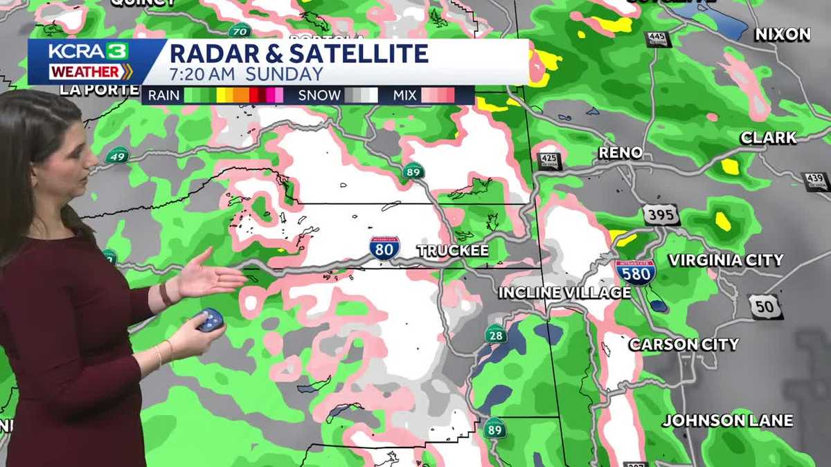
Cool and showery weather continues for Northern California on Sunday. The activity will primarily be in the Foothills and Sierra, with showers becoming lighter and more widely scattered throughout the day. In the Sierra, snow levels fell to around 7,000 feet overnight and there was minor snow accumulation on I-80 near Donner Summit. Snow levels will rise later in the morning and the snow is likely to melt. As of 9 a.m., chain controls were in effect on Interstate 80 from Kingvale to the Donner Lake Interchange. See the latest chain control updates here. A Sierra wind advisory remains in place through Sunday. Wind gusts could reach 55 mph around the Lake Tahoe area. Lake Tahoe waves of 2-5 feet are possible. The Valley will continue to have plenty of dry time Sunday. High temperatures will stay in the 60s. Morning lows will be in the low 50s. The Foothills are expected to be a little wetter.Rain totals Below are rain totals over the past 24 hours, as of Sunday at 7 a.m.. Sacramento — 0.05 inchStockton — 0.03 inch Blue Canyon – 0.42 inchOroville — 0.22 inchRedding — 0.59 inch REAL-TIME TRAFFIC MAPClick here to see our interactive traffic map.TRACK INTERACTIVE, DOPPLER RADARClick here to see our interactive radar.DOWNLOAD OUR APP FOR THE LATESTHere is where you can download our app.Follow our KCRA weather team on social mediaMeteorologist Tamara Berg on Facebook and X.Meteorologist Dirk Verdoorn on FacebookMeteorologist Heather Waldman on Facebook and X.Meteorologist Kelly Curran on X.Meteorologist Ophelia Young on Facebook and X.Watch our forecasts on TV or onlineHere’s where to find our latest video forecast. You can also watch a livestream of our latest newscast here. The banner on our website turns red when we’re live.We’re also streaming on the Very Local app for Roku, Apple TV or Amazon Fire TV.See more coverage of top California stories here | Download our app | Subscribe to our morning newsletter | Find us on YouTube here and subscribe to our channel
Cool and showery weather continues for Northern California on Sunday.
The activity will primarily be in the Foothills and Sierra, with showers becoming lighter and more widely scattered throughout the day.
In the Sierra, snow levels fell to around 7,000 feet overnight and there was minor snow accumulation on I-80 near Donner Summit. Snow levels will rise later in the morning and the snow is likely to melt.
As of 9 a.m., chain controls were in effect on Interstate 80 from Kingvale to the Donner Lake Interchange.
A Sierra wind advisory remains in place through Sunday. Wind gusts could reach 55 mph around the Lake Tahoe area.
Lake Tahoe waves of 2-5 feet are possible.
The Valley will continue to have plenty of dry time Sunday. High temperatures will stay in the 60s. Morning lows will be in the low 50s. The Foothills are expected to be a little wetter.
Rain totals
Below are rain totals over the past 24 hours, as of Sunday at 7 a.m..
Sacramento — 0.05 inchStockton — 0.03 inch Blue Canyon – 0.42 inchOroville — 0.22 inchRedding — 0.59 inch
REAL-TIME TRAFFIC MAP
Click here to see our interactive traffic map.
TRACK INTERACTIVE, DOPPLER RADAR
Click here to see our interactive radar.
DOWNLOAD OUR APP FOR THE LATEST
Here is where you can download our app.
Follow our KCRA weather team on social media
Meteorologist Tamara Berg on Facebook and X.Meteorologist Dirk Verdoorn on FacebookMeteorologist Heather Waldman on Facebook and X.Meteorologist Kelly Curran on X.Meteorologist Ophelia Young on Facebook and X.
Watch our forecasts on TV or online
Here’s where to find our latest video forecast. You can also watch a livestream of our latest newscast here. The banner on our website turns red when we’re live.
We’re also streaming on the Very Local app for Roku, Apple TV or Amazon Fire TV.
See more coverage of top California stories here | Download our app | Subscribe to our morning newsletter | Find us on YouTube here and subscribe to our channel