
March 2026 is about to go down as Northern California’s warmest March on record. The return of rain and snow on the final day of the month could prevent it from also being the driest. Scattered showers will begin popping up in the Valley, Foothills and Sierra on Tuesday morning. Wet weather is in the forecast through early Thursday morning. The snow level will drop enough for accumulation at the Tahoe area summits. Wednesday is a KCRA 3 weather Impact Day specifically for the Sierra because snow and wind will affect travel in the mountains.Here is what the KCRA 3 weather team is expecting during the next few days.SierraTuesday will be a soggy day in the mountains. The snow level will stay above the passes during the day, but rain will keep roads wet. The snow level will drop Tuesday night through Wednesday night. Snow will accumulate at Donner Summit, Echo Summit and Carson Summit during the day Wednesday and Wednesday night. Drivers should expect chain controls and long delays if there are accidents. Wednesday will also be windy with gusts to 40 mph. Wednesday is a KCRA 3 weather Impact Day because of the expected travel issues.Donner Summit could see 4 to 8 inches of snow. Echo Summit will see slightly lower totals. Carson Summit will see slightly higher totals. Thursday could start with a few snow showers, but the day will dry out quickly, and road conditions will improve. FoothillsThe Foothills will be much cooler with lots of low clouds and periods of light to moderate rain Tuesday and Wednesday. A rumble of thunder is possible, too.High temperatures will stay in the low 60s.Rain will be on and off on Tuesday, but it could be steadier on Wednesday. The breeze will pick up Wednesday with some gusts to 25 mph. Areas with more persistent showers could see up to an inch of rain by Thursday morning. This is most likely in communities north of Highway 50. ValleyShowers will be scattered both Tuesday and Wednesday in the Valley. No one will see an all-day rain and some could end up seeing very little. Places with the most frequent showers could pick up around a quarter-inch of rain. It is possible that some places will not get measurable rainfall, especially in the San Joaquin Valley.Wednesday will also be a breezier day with gusts to 25 mph at times. Clouds will be widespread and temperatures will finally stay closer to normal for the end of March. High temperatures are forecast to be in the upper 60s Tuesday, Wednesday and Thursday.REAL-TIME TRAFFIC MAPClick here to see our interactive traffic map.TRACK INTERACTIVE, DOPPLER RADARClick here to see our interactive radar.DOWNLOAD OUR APP FOR THE LATESTHere is where you can download our app.Follow our KCRA weather team on social mediaMeteorologist Tamara Berg on Facebook and X.Meteorologist Dirk Verdoorn on FacebookMeteorologist/Climate Reporter Heather Waldman on Facebook and X.Meteorologist Kelly Curran on X.Meteorologist Ophelia Young on Facebook and X.Watch our forecasts on TV or onlineHere’s where to find our latest video forecast. You can also watch a livestream of our latest newscast here. The banner on our website turns red when we’re live.We’re also streaming on the Very Local app for Roku, Apple TV or Amazon Fire TV.See more coverage of top California stories here | Download our app | Subscribe to our morning newsletter | Find us on YouTube here and subscribe to our channel
March 2026 is about to go down as Northern California’s warmest March on record. The return of rain and snow on the final day of the month could prevent it from also being the driest.
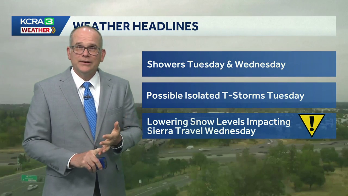
Scattered showers will begin popping up in the Valley, Foothills and Sierra on Tuesday morning. Wet weather is in the forecast through early Thursday morning.
The snow level will drop enough for accumulation at the Tahoe area summits. Wednesday is a KCRA 3 weather Impact Day specifically for the Sierra because snow and wind will affect travel in the mountains.
Here is what the KCRA 3 weather team is expecting during the next few days.
Sierra
Tuesday will be a soggy day in the mountains. The snow level will stay above the passes during the day, but rain will keep roads wet.
The snow level will drop Tuesday night through Wednesday night. Snow will accumulate at Donner Summit, Echo Summit and Carson Summit during the day Wednesday and Wednesday night.

Hearst Owned
The snow level will drop low enough for accumulations at the Tahoe area summits Wednesday and Wednesday night.
Drivers should expect chain controls and long delays if there are accidents. Wednesday will also be windy with gusts to 40 mph.
Wednesday is a KCRA 3 weather Impact Day because of the expected travel issues.

Hearst Owned
Snow will accumulate fastest Wednesday and Wednesday night.
Donner Summit could see 4 to 8 inches of snow. Echo Summit will see slightly lower totals. Carson Summit will see slightly higher totals.
Thursday could start with a few snow showers, but the day will dry out quickly, and road conditions will improve.
Foothills
The Foothills will be much cooler with lots of low clouds and periods of light to moderate rain Tuesday and Wednesday. A rumble of thunder is possible, too.
High temperatures will stay in the low 60s.
Rain will be on and off on Tuesday, but it could be steadier on Wednesday. The breeze will pick up Wednesday with some gusts to 25 mph.

Hearst Owned
Rain totals will gradually add up Tuesday and Wednesday.
Areas with more persistent showers could see up to an inch of rain by Thursday morning. This is most likely in communities north of Highway 50.
Valley
Showers will be scattered both Tuesday and Wednesday in the Valley. No one will see an all-day rain and some could end up seeing very little.
Places with the most frequent showers could pick up around a quarter-inch of rain. It is possible that some places will not get measurable rainfall, especially in the San Joaquin Valley.
Wednesday will also be a breezier day with gusts to 25 mph at times.
Clouds will be widespread and temperatures will finally stay closer to normal for the end of March. High temperatures are forecast to be in the upper 60s Tuesday, Wednesday and Thursday.
REAL-TIME TRAFFIC MAP
Click here to see our interactive traffic map.
TRACK INTERACTIVE, DOPPLER RADAR
Click here to see our interactive radar.
DOWNLOAD OUR APP FOR THE LATEST
Here is where you can download our app.
Follow our KCRA weather team on social media
Meteorologist Tamara Berg on Facebook and X.Meteorologist Dirk Verdoorn on FacebookMeteorologist/Climate Reporter Heather Waldman on Facebook and X.Meteorologist Kelly Curran on X.Meteorologist Ophelia Young on Facebook and X.
Watch our forecasts on TV or online
Here’s where to find our latest video forecast. You can also watch a livestream of our latest newscast here. The banner on our website turns red when we’re live.
We’re also streaming on the Very Local app for Roku, Apple TV or Amazon Fire TV.
See more coverage of top California stories here | Download our app | Subscribe to our morning newsletter | Find us on YouTube here and subscribe to our channel