
Little to no precipitation has fallen across California in March, with many areas south of San Francisco receiving zero rainfall.
Baron/Lynx
Bay Area residents may notice something Tuesday they haven’t seen in weeks: raindrops.
High pressure is moving out, opening the door for a couple of wet weather systems to clip California. Neither system is expected to be particularly stormy, but they’re likely to end a 40-day long spell of dry weather in parts of the Bay Area.
Tuesday’s system lacks organization. Throw a bunch of paint at a canvas and that may have more uniformity than what the radar could look like Tuesday. Predicting exactly when and where rain showers will form is tricky, so it’s a good idea to keep a rain jacket or umbrella handy.
Article continues below this ad
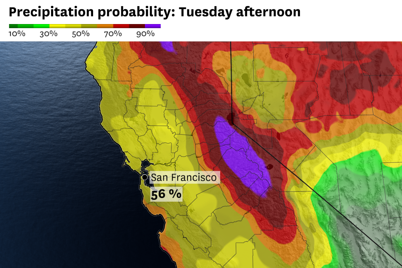
Disorganized rain showers are predicted across the Bay Area on Tuesday, with greater chances of steady light rain in Central California.
Baron/Lynx
While showers could catch people off guard, they aren’t expected to be heavy. Rainfall totals will likely be less than a tenth of an inch in most cities. There’s a slight chance of a rumble of thunder and a brief downpour in the Central Valley, though thunderstorms are not forecast in the Bay Area.
Either way, it’ll probably be enough to snap the weekslong dry spell that began March 2 in San Francisco. Much of the East Bay and South Bay haven’t seen a lick of rain the entire month. San Jose has been dry for nearly six weeks, with Feb. 19 marking the most recent wet day there.
San Francisco Chronicle Logo
Make us a Preferred Source to get more of our news when you search.
Add Preferred Source
Wednesday will bring another shot of wet weather.
Article continues below this ad
After a mainly dry morning, a cold front will reach the North Bay in the afternoon and San Francisco and Oakland in the evening. A few hours of light to moderate rain and breezy winds are possible as the front moves through. Behind the front, temperatures will drop to the upper 30s to mid-40s for the coldest night since February in many areas.
Light rain totals this week will only provide modest relief for a landscape that has dried out rapidly in March. While no parts of California are meeting official drought classification, the National Oceanic and Atmospheric Administration highlights most of the Bay Area for maximum dryness on its Evaporative Demand Drought Index. The index is a measure of the “the thirst of the atmosphere” and serves as something of an early warning system for agricultural dryness and fire risk.
The National Weather Service forecasts a 50% to 70% chance of at least 0.01 inch of rain in San Francisco on Tuesday afternoon. Continued rain showers Wednesday into Thursday morning are likely to snap the city’s dry spell at four weeks.
Baron/Lynx
After a few lingering showers Thursday morning, warmer and drier weather is forecast through the weekend. Below-normal precipitation is favored through mid-April, according to the National Weather Service. NOAA forecasts that unusually high levels of evaporation will continue in April.
Tuesday breakdown
San Francisco: The city’s best Los Angeles impression is over, as cool marine air and rain showers return. It’ll be overcast, with off and on light rain showers. Rainfall amounts will probably be less than a tenth of an inch. Highs will be in the low 60s west of Twin Peaks and mid-60s to the east, including downtown. Westerly gusts of 10 to 15 mph are expected. Overnight lows will be in the low to mid-50s, with a slight chance of showers.
Article continues below this ad
North Bay: Cooler weather will be accompanied by overcast skies and isolated rain showers. With highs only in the mid- to upper 60s, it’ll be the coolest day since early March in Santa Rosa, San Rafael and Napa. Vacaville may still reach 70 degrees, though even that will be cool relative to recent weeks. Rain showers probably won’t add up to more than a tenth of an inch in most places. Overnight lows will be in the upper 40s to mid-50s.
East Bay: Scattered rain showers, overcast skies and occasional breezes will highlight the coolest day of weather in weeks. Alameda County has the best chance of showers, though they could push into Contra Costa County, too. Rainfall totals will probably remain below a tenth of an inch. Highs will be in the mid-60s in Richmond, Berkeley, Oakland and Hayward and the upper 60s to low 70s in Fremont, Livermore, Concord and Antioch. Overnight lows will be in the low to mid-50s, with a slight chance of showers.
Pacific Coast and Peninsula: Overcast skies with a chance of rain showers is expected all day. Rainfall totals probably won’t add up to more than a tenth of an inch, though. Wind gusts will be less than 20 mph, except in the hills. Highs will be in the low to mid-60s along Highway 1 and the mid- to upper 60s along the Highway 101 and Interstate 280 corridor. Off and on showers may linger overnight as temperatures remain in the low to mid-50s under a blanket of clouds.
South Bay and Santa Cruz: Light showers are possible across the South Bay and Santa Cruz Mountains, though rainfall totals will probably remain below a tenth of an inch. Highs will be in the upper 60s to low 70s, except for in Santa Cruz where it’ll remain in the mid-60s, under overcast skies. Overnight lows will be in the upper 40s to mid-50s with continued light showers and mostly cloudy skies.
Article continues below this ad