
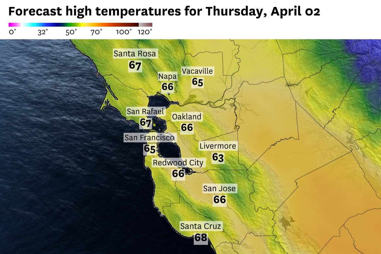
Forecast high temperatures across the Bay Area on Thursday, April 2, show a narrow range from the mid-60s at the coast to the upper 60s inland. Warmer conditions are expected to build through the weekend.
Baron/Lynx
A cold front swept through the region overnight, bringing rain to most of the Bay Area and dropping temperatures back to seasonal levels.
The rain itself was no record-setter, but it was welcome. Totals of 0.1 to 0.25 inches fell across most of the region, with higher amounts localized in the North Bay hills, where air rising to higher elevations squeezed out extra moisture in what’s known as “orographic lift.” The National Weather Service noted it was a best-case scenario for both water storage and fire weather concerns after an unusually warm and dry March.
That is all behind us now. Thursday is a transitional day, one of those crisp, blue-sky days that require sunglasses and a sweater.
Article continues below this ad
The aforementioned cold front will be well clear of the region by sunrise Thursday, and a much drier air mass will work its way in throughout the day. That will translate to a bright and sunny day with few, if any, clouds.
We will be left with gusty northwest winds, though, which will keep temperatures from climbing too high. Most areas will see temperatures similar to Wednesday, with the Pacific Coast the main exception. Highs will hold near 60 degrees at Half Moon Bay and Pacifica under a stiff onshore breeze.
Thursday night is when the forecast begins to shift again. Offshore flow or winds from the north/northeast are expected to develop after dark, driving winds back up across the region. The biggest impacts will be felt in the North Bay interior mountains, where gusts could reach 40 to 50 mph by early Friday morning. Elsewhere, overnight winds will be breezy but notably weaker, generally in the 10 to 20 mph range.
San Francisco Chronicle Logo
Make us a Preferred Source to get more of our news when you search.
Add Preferred Source
That sets the stage for a warming trend that begins Friday and should last into the weekend.
Article continues below this ad
San Francisco: San Franciscans should wake up to bright, sunny skies in the morning. Northwest winds will keep a chill in the air, with gusts reaching 20 to 25 mph downtown and up to 30 mph near the water and atop Twin Peaks. Highs will reach the mid-60s downtown, with cooler readings in the upper 50s to low 60s in the western neighborhoods and at Ocean Beach. Thursday night will stay breezy, but skies remain clear with temperatures in the upper 40s to low 50s.
North Bay: The North Bay absorbed the heaviest rainfall of the past several days, but that will be firmly in the rearview mirror. Expect plenty of sunshine and a brisk northwest wind with gusts reaching 25 to 30 mph along Marin and Sonoma ridgelines during the afternoon. Highs will be in the low to mid-60s in Napa and Novato, with cooler readings along the immediate coast. Winds will shift offshore overnight and increase significantly in the interior mountains, where gusts could reach 40 to 50 mph by Friday morning. Lows will fall back into the upper 30s to low 40s.
East Bay: The East Bay should end up being the warmest region. Skies will be sunny and clear from the get-go, with temperatures rising into the upper 60s both in Oakland and Hayward as well as in the interior valleys like Walnut Creek and Dublin. Northwest winds will be gusty close to the bay at 15 to 25 mph. Winds will be a bit lighter further inland. Overnight will be clear and crisp as temperatures fall back into the low to mid-40s.
Pacific Coast: The Pacific Coast will be the coolest and breeziest part of the Bay Area. Skies will be sunny, but temperatures will only top out right around 60 degrees at Half Moon Bay, Pacifica and Daly City. Winds will be strong out of the northwest, gusting from 25 to 35 mph. Overnight, a few clouds may pop up and the winds should calm a bit with temperatures bottoming out in the mid-to upper 40s.
Article continues below this ad
Peninsula: This is one of those days where some of the strongest winds whip through the San Bruno Gap towards SFO and other spots on the east side of the Peninsula. Gusts from the northwest will range from 20 to 30 mph, with some isolated higher gusts. Temperatures will be relatively uniform throughout, ranging from the low 60s in South San Francisco to the mid-60s in Redwood City. It will be mostly clear overnight with much calmer winds and temperatures dropping into the 40s.
South Bay: It will be a comfortable day in the South Bay. Temperatures will rise into the mid- to upper 60s in Gilroy, Santa Clara and San Jose under sunny skies. The region should be shielded from the wind somewhat, with gusts from the northwest at 10 to 15 mph. Those winds will die off overnight, leaving clear and cool conditions with lows in the mid-to-upper 40s.