
Northern California forecast: Dry and sunnier but breezy Monday
Our unsettled weekend system is moving east. Meanwhile, Northern California can look forward to a lovely week to close out October.
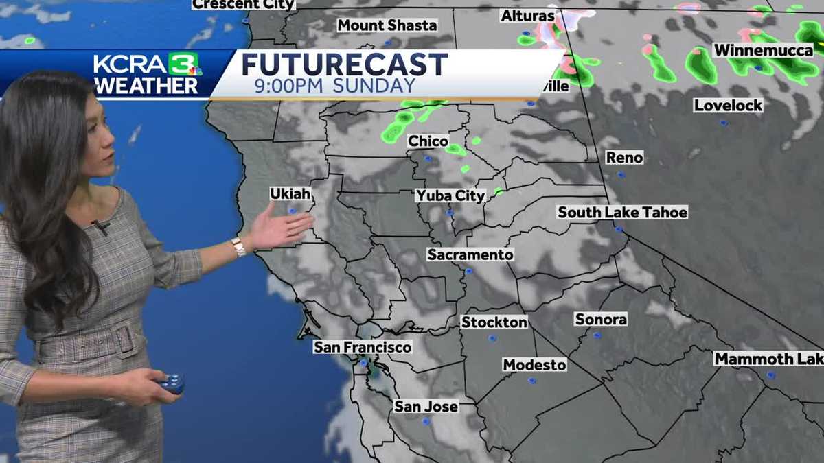
OVER TO KCRA 3 METEOROLOGIST. OPHELIA YOUNG. YEAH, ASHLEY. STILL A VERY DANGEROUS SITUATION FOR JAMAICA. IT’S GOING TO BE A ROUGH COUPLE OF DAYS AHEAD FOR THEM. HURRICANE MELISSA LOOKING LIKE A BUZZ SAW AS IT SPINS JUST SOUTH OF THE ISLAND. YOU CAN SEE IT’S GOT A VERY HEALTHY AND HOLLOWED OUT EYE. AND IT IS MOVING WEST. BUT THE GOOD NEWS IS THAT IT HAS PICKED UP A LITTLE BIT OF SPEED NOW MOVING AT FIVE MILES PER HOUR. COMPARE THAT TO THE THREE THAT IT WAS MOVING AT YESTERDAY. STILL SUSTAINED WINDS UP TO 145MPH WITHIN THE STORM. THAT DOES MAKE IT A CATEGORY FOUR MAJOR HURRICANE, AND IT HAS STRENGTHENED. IT IS EXPECTED TO STRENGTHEN TO A FIVE JUST BEFORE CUTTING ACROSS JAMAICA. THAT WILL BE EARLY TUESDAY MORNING. OUR TIME, AND THEN IT WILL DOWNGRADE TO A THREE AS IT SWIPES CUBA, THE VERY EASTERN TIP, AND THEN DOWNGRADE TO A TWO AS IT MOVES BACK OUT INTO THE ATLANTIC, BRINGING THINGS BACK HERE TO THE WEST COAST, A LITTLE ROUGH UP IN THE MOUNTAINS. THIS IS FROM DONNER SUMMIT, WHERE YOU CAN TELL WE HAVE SOME WINDS THAT ARE SHAKING AROUND OUR CAMERA. THE ROADS ARE WET, HAVE A LITTLE BIT OF ACCUMULATION OF SNOW ON THE SIDE OF THE ROADS THERE. THEY DID GET SOME FLAKES, BUT IT SEEMS LIKE NOT TOO MUCH STICKED ON THE STUCK ON THE ROADS. THAT’S WHERE THE MOST RAIN FELL. YOU CAN SEE THAT BLUE THAT IS RUNNING RIGHT BETWEEN AUBURN AND TRUCKEE. THAT IS THE PEAK OF THE NORTHERN SIERRAS. GOT ABOUT AN INCH OF RAIN IN DONNER LAKE A LITTLE FURTHER DOWN THE FOOTHILLS. AUBURN GOT MORE THAN A 10TH THESE LAST COUPLE DAYS, AND IN THE VALLEY, MINIMAL, BUT 0.01 SOMETHING MEASURABLE. TODAY WE WILL TAKE THAT SOUTH LAKE TAHOE ENDED UP NOT DOING TOO BAD WITH MORE THAN A THIRD OF AN INCH. THIS WEEKEND. SO TODAY’S ROUND OF SHOWERS. A LITTLE BIT MORE FRUITFUL THAN YESTERDAY. HERE YOU SEE THE LITTLE GHOST OF THE VERY LAST PUSH OF MOISTURE THAT MOVED THROUGH THIS LATE AFTERNOON. WE STILL HAVE A LINE OF SHOWERS RUNNING DOWN THE FOOTHILLS, FEW LINGERING SHOWERS AND GRASS VALLEY ALL THE WAY DOWN TO AUBURN. MIGHT BE SEEING A FEW DROPS OF RAIN. GRANITE BAY FOLSOM CAMERON PARK THAT LINE OF SHOWERS ALL THE WAY DOWN INTO THE SOUTH BAY, JUST SOUTH OF SAN JOSE. NOW, WHAT’S LEFT OF THOSE SHOWERS CONTINUES TO MOVE EAST, AND OVERNIGHT, EVEN THE CLOUDS ARE GOING TO BREAK. TOMORROW IS GOING TO BE A SUNNIER DAY, BUT IT WILL ALSO BE A BREEZY DAY WITH WINDS NOW MOVING OUT OF THE NORTHWEST ABOUT 15MPH. TEMPERATURES WILL BE NOTICEABLY WARMER, THOUGH WE’LL TOP OUT IN THE LOW 70. SO LET’S BREAK DOWN THE WINDS TOMORROW. GOT A LITTLE BREEZE CURRENTLY IN THE WEST VALLEY AND ALSO IN THE SIERRA. THAT SHOULD DIE DOWN BY LATE EVENING. CALM OVERNIGHT. BUT QUIETLY THOUGH, THOSE WINDS ARE GOING TO SWITCH FROM FLOWING OUT OF THE WEST TO FLOWING OUT OF THE NORTH. AS THE SYSTEM DEPARTS TO OUR EAST, AND THEN WE’LL HAVE SOME NORTH WINDS TOMORROW, AND THAT’S GOING TO GIVE US A NICE TEMPERATURE BUMP TOMORROW. LOOKING AT TEMPERATURES CLIMBING BACK INTO THE 70S FOR THE VALLEY, WE HAVE 60S FOR THE FOOTHILLS WITH TRUCKEE AND SOUTH LAKE TAHOE WILL CLIMB BACK INTO THE MID TO UPPER 50S. TEMPS CONTINUE TO GO UP FROM THERE FOR THE WEEK. WE’RE BACK IN THE MID 70S. TUESDAY, WEDNESDAY, UPPER 70S. TAKE A LOOK AT HALLOWEEN 77 DEGREES, LIGHT WINDS AND MOSTLY CLEAR SKIES. WE’VE GOT A GOOD EVENING FOR KIDS TO GO TRICK OR TREATING.
Northern California forecast: Dry and sunnier but breezy Monday
Our unsettled weekend system is moving east. Meanwhile, Northern California can look forward to a lovely week to close out October.

Updated: 9:26 PM PDT Oct 26, 2025
Our unsettled weekend system is moving east. Meanwhile, Northern California can look forward to a lovely week to close out October.A few clouds may linger Monday morning but will clear by afternoon, with valley highs returning to the low 70s, foothill highs in the mid-60s, and Sierra highs in the mid to upper 50s.Another lingering impact from the storm is northerly wind as the system departs to the east. Breezy conditions will be most noticeable in the valley, especially west of Interstate 5, with winds diminishing by early evening.The rest of the week will be quiet, with valley highs hovering in the mid to upper 70s and occasional cloud cover, particularly on Thursday with a passing system.Halloween looks phenomenal, with highs near 77 degrees, then temperatures easing into the 60s with light winds and mostly clear skies for trick-or-treating.
SACRAMENTO, Calif. —
Our unsettled weekend system is moving east. Meanwhile, Northern California can look forward to a lovely week to close out October.
A few clouds may linger Monday morning but will clear by afternoon, with valley highs returning to the low 70s, foothill highs in the mid-60s, and Sierra highs in the mid to upper 50s.
Another lingering impact from the storm is northerly wind as the system departs to the east. Breezy conditions will be most noticeable in the valley, especially west of Interstate 5, with winds diminishing by early evening.
The rest of the week will be quiet, with valley highs hovering in the mid to upper 70s and occasional cloud cover, particularly on Thursday with a passing system.
Halloween looks phenomenal, with highs near 77 degrees, then temperatures easing into the 60s with light winds and mostly clear skies for trick-or-treating.