
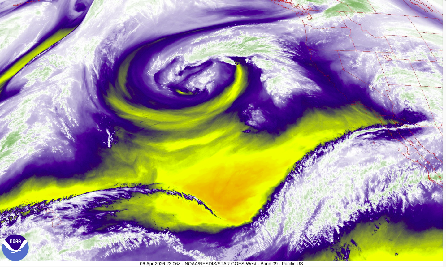
Water vapor imagery from the NOAA GOES-West satellite captured this striking spiral of clouds off the California coast Monday evening. The swirling system is a cut-off low, a storm that has broken away from the jet stream and is slowly drifting toward the Bay Area, where rain and a chance of thunderstorms are expected by Friday.
NOAA
The weather pattern that will hit California this week looks spectacular on satellite.
Imagery from the NOAA GOES-West satellite, orbiting 22,236 miles above the surface, shows a large spiral of clouds spinning off the California coast.
Article continues below this ad
That spiral is a cut-off low. A cut-off low forms when a dip in the jet stream deepens so dramatically that it pinches off entirely, leaving a pocket of cold air spinning in isolation with no steering flow to push it along. The system slows, wobbles, and can linger for days, making it one of the harder setups for forecasters to pin down.
They’re also a signature of the season. Spring is one of the more active periods for cut-off lows along the West Coast. As the jet stream begins its annual retreat northward and weakens in the process, it becomes more prone to these pinch-off events, leaving isolated pockets of cold air to drift and spin on their own.
This particular cut-off low will take its time moving toward California and won’t get close to the coast until sometime on Thursday. That leaves Tuesday and Wednesday with mostly sunny skies and temperatures in the 60s and 70s. Once the low does approach, it will bring cooler, cloudier and generally more unsettled weather conditions with it into the weekend, including showers likely by Friday and a slight chance of thunderstorms.
Tuesday breakdown
San Francisco: Tuesday’s weather will be a near carbon copy of Monday’s conditions. Low clouds will linger across the city all morning, gradually breaking up in the afternoon in Haight Ashbury, Bernal Heights and Mission Bay. Temperatures in those spots will top out in the mid-to upper 60s. No such luck in the neighborhoods west of Twin Peaks, where clouds will be in place for much of the day and highs top out in the upper 50s to low 60s. Winds from the west will pick up in the afternoon at 10 to 20 mph. It will be partly cloudy overnight with lows in the upper 40s to low 50s.
Article continues below this ad
San Francisco Chronicle Logo
Make us a Preferred Source to get more of our news when you search.
Add Preferred Source
North Bay: Low clouds will cover the Marin headlands and parts of the Highway 101 corridor on Tuesday morning. Those clouds should clear quickly though, and much of the North Bay will see sunshine for the rest of the day. Temperatures will warm into the mid-70s in Novato, Petaluma, Napa and Vallejo and into the upper 70s in Santa Rosa. Winds will be from the west-northwest at 10 to 15 mph. Clouds will return to Marin and parts of the 101 corridor overnight, with lows in the upper 40s.
East Bay: Pockets of clouds will hover along the I-580/80 corridor on Tuesday morning, mainly around Berkeley and Oakland. But they should clear pretty quickly, leaving mostly sunny skies for the rest of the day. Temperatures will be comfortable, with highs in the low 70s in Richmond and Oakland and the mid- to upper 70s in Walnut Creek and Dublin. Winds will be light out of the west at 10 to 15 mph. Overnight, clouds will work their way back in west of the Berkeley hills while staying clear inland, with lows in the upper 40s to low 50s.
Pacific Coast:Low clouds and areas of fog will persist through most of the morning along the coastal strip, with only partial clearing by early afternoon. Highs will stay in the upper 50s to low 60s with a northwest wind at 5 to 10 mph. It will be mostly cloudy overnight with patchy fog returning and lows in the upper 40s.
Article continues below this ad
Peninsula: Low clouds will hug the I-280 corridor and the coastal hills on Tuesday morning, Those clouds will retreat toward the coast by early afternoon, allowing sunshine to break through across much of the Peninsula. Temperatures will top out in the mid-60s in South San Francisco and SFO, and in the low 70s in Redwood City and San Mateo. Winds from the northwest should pick up in the afternoon at 10 to 20 mph. Clouds will work their way back in overnight, with lows in the upper 40s to low 50s.
South Bay: Tuesday will feel a touch cooler than Monday across the South Bay. Any morning cloud cover will dissipate by the mid-morning, giving way to mostly sunny skies. Highs will reach the low-to-mid 70s in San Jose, Sunnyvale and Santa Clara, with Morgan Hill and Gilroy warming into the mid-to-upper 70s. Skies will be mostly clear overnight with temperatures dropping back into the upper 40s.