
Multiple severe thunderstorm warnings were issued for parts of the Central Valley on Friday. The severe weather has been expected. The KCRA 3 weather team issued an Alert Day because of the forecast for damaging hail, heavy downpours and the chance for funnel clouds.We’ll continue to update this story should new warnings be issued. Track interactive radar hereDownload our app for the latest alertsShare your photos and videos at KCRA.com/upload | See viewer submissions hereCurrent severe weather warnings None. Expired warnings The first was issued around 2 p.m. when a severe thunderstorm was located near the Ripon area, moving northeast at 15 mph. NWS warned of quarter-sized hail, which could damage vehicles, as well as winds of up to 50 mph. Impacted areas include Modesto, Manteca, Ripon, Escalon, Del Rio and Salida.The warning was in effect until 2:30 p.m., NWS said.At 2:12 p.m., NWS issued a second severe thunderstorm warning for Stanislaus County. A severe thunderstorm was spotted near Turlock, moving northeast at 25 mph, bringing quarter-sized hail with it. Vehicles were also likely to be damaged.This warning was in effect until 2:45 p.m. NWS said the impacted areas included Turlock, Waterford, Hickman and Denair.NWS said another warning was for Stanislaus County after a severe thunderstorm was spotted near Hickman around 2:37 p.m. It was moving northeast at 30 mph, bringing quarter-sized hail with it. Locations include Waterford and Hickman. It expired at 3 p.m. When these warnings are issued, people are recommended to stay indoors.Another warning was in effect for parts of Calaveras, San Joaquin and Stanislaus counties. NWS said a severe thunderstorm was spotted over Farmington, bringing quarter-sized hail with it. It was moving northeast at 25 mph, impacting the Farmington and Milton areas. It expired at 3:10 p.m.Another warning was in effect for parts of Sacramento, San Joaquin, Solano and Yolo counties. As of 3 p.m. it was located over Rio Vista and moving north at 25 mph. It was bringing ping pong-sized hail. Impacted locations could include Rio Vista, Paintersville, Liberty Farm, Isleton and Courtland. This warning expired at 3:30 p.m.A severe thunderstorm warning was in effect for parts of Calaveras and Tuolumne Counties. As of 4:15 p.m., a severe storm was located over Jupiter and moving northeast at 30 mph. Quarter-sized hail and damage to vehicles was expected. People are urged to move to an interior room on the lowest floor of a building. The warning has since expired. A flash flood warning for parts of Colusa County was in effect until 7:15 p.m. As of 5:21 p.m., thunderstorms were causing flash flooding or expected to cause flash flooding at small creeks and streams, urban areas, highways and streets and underpasses.A severe thunderstorm warning was in effect for Colusa County until 7:45 p.m. As of 7:06 p.m. a severe thunderstorm was located over Afton and moving northeast at 20 mph. It could cause damage to vehicles with quarter-sized hail.A severe thunderstorm warning was in effect for Calaveras, San Joaquin and Stanislaus counties until 7:45 p.m. A severe thunderstorm was moving near Oakdale. It could also cause quarter-sized hail.This is a developing story. Stay with KCRA 3 for the latest.See news happening? Send us your photos or videos if it’s safe to do so at kcra.com/upload.See more coverage of top California stories here | Download our app | Subscribe to our morning newsletter | Find us on YouTube here and subscribe to our channel
Multiple severe thunderstorm warnings were issued for parts of the Central Valley on Friday.
The severe weather has been expected. The KCRA 3 weather team issued an Alert Day because of the forecast for damaging hail, heavy downpours and the chance for funnel clouds.
We’ll continue to update this story should new warnings be issued.
Current severe weather warnings
None.
Expired warnings
The first was issued around 2 p.m. when a severe thunderstorm was located near the Ripon area, moving northeast at 15 mph. NWS warned of quarter-sized hail, which could damage vehicles, as well as winds of up to 50 mph. Impacted areas include Modesto, Manteca, Ripon, Escalon, Del Rio and Salida.
The warning was in effect until 2:30 p.m., NWS said.
At 2:12 p.m., NWS issued a second severe thunderstorm warning for Stanislaus County. A severe thunderstorm was spotted near Turlock, moving northeast at 25 mph, bringing quarter-sized hail with it. Vehicles were also likely to be damaged.
This warning was in effect until 2:45 p.m. NWS said the impacted areas included Turlock, Waterford, Hickman and Denair.
NWS said another warning was for Stanislaus County after a severe thunderstorm was spotted near Hickman around 2:37 p.m. It was moving northeast at 30 mph, bringing quarter-sized hail with it. Locations include Waterford and Hickman. It expired at 3 p.m.
When these warnings are issued, people are recommended to stay indoors.
Another warning was in effect for parts of Calaveras, San Joaquin and Stanislaus counties. NWS said a severe thunderstorm was spotted over Farmington, bringing quarter-sized hail with it. It was moving northeast at 25 mph, impacting the Farmington and Milton areas. It expired at 3:10 p.m.
Another warning was in effect for parts of Sacramento, San Joaquin, Solano and Yolo counties. As of 3 p.m. it was located over Rio Vista and moving north at 25 mph. It was bringing ping pong-sized hail. Impacted locations could include Rio Vista, Paintersville, Liberty Farm, Isleton and Courtland. This warning expired at 3:30 p.m.
A severe thunderstorm warning was in effect for parts of Calaveras and Tuolumne Counties. As of 4:15 p.m., a severe storm was located over Jupiter and moving northeast at 30 mph. Quarter-sized hail and damage to vehicles was expected. People are urged to move to an interior room on the lowest floor of a building. The warning has since expired.
A flash flood warning for parts of Colusa County was in effect until 7:15 p.m. As of 5:21 p.m., thunderstorms were causing flash flooding or expected to cause flash flooding at small creeks and streams, urban areas, highways and streets and underpasses.
A severe thunderstorm warning was in effect for Colusa County until 7:45 p.m. As of 7:06 p.m. a severe thunderstorm was located over Afton and moving northeast at 20 mph. It could cause damage to vehicles with quarter-sized hail.
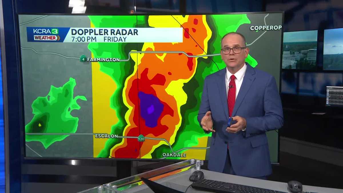
A severe thunderstorm warning was in effect for Calaveras, San Joaquin and Stanislaus counties until 7:45 p.m. A severe thunderstorm was moving near Oakdale. It could also cause quarter-sized hail.
This is a developing story. Stay with KCRA 3 for the latest.
See news happening? Send us your photos or videos if it’s safe to do so at kcra.com/upload.
See more coverage of top California stories here | Download our app | Subscribe to our morning newsletter | Find us on YouTube here and subscribe to our channel