
As this storm system winds down, the focus now turns to the impressive rain and snow totals left behind across Northern California, and the boost it provided to seasonal rainfall numbers.In the valley, rainfall totals ranged from about half an inch in Modesto to roughly 1.3 inches in both Sacramento and Stockton since Thursday. While those amounts were manageable for most lower elevations, parts of the foothills saw much heavier rain. Some foothill communities were placed under a flood advisory over the weekend, with storm totals climbing above 4 inches of rain.Below are rain totals as of 11:00 p.m. April 12:The latest rain also helped improve water year standings. Sacramento has climbed back to around 85% of normal for this point in the season, while Stockton is now at 112% and Modesto at 109%.Around the Lake Tahoe region, the storm delivered abundant rainfall before colder air helped change that moisture over to snow.Below is a list of snow totals from local SNOTEL sites in the Sierra as of 10:00 p.m. April 12:In Truckee, the SNOTEL site has recorded 16 inches of snow since Thursday. Closer to the Sierra summits, snowfall totals were even more impressive. Palisades Tahoe picked up nearly 3 feet of snow, while SNOTEL sites at Carson Pass and Heavenly Valley each reported around 2 feet. Mount Rose measured close to a foot and a half.While storm impacts significantly subsided early Monday morning, the Sierra is not completely done with this system yet. A few more showers are expected through Monday as the storm wraps moisture back into the mountains from the northeast.Conditions are improving for the valley, but the Sierra will continue to see lingering impacts a bit longer as this Spring season storm system finally pulls away.REAL-TIME TRAFFIC MAPClick here to see our interactive traffic map.TRACK INTERACTIVE, DOPPLER RADARClick here to see our interactive radar.DOWNLOAD OUR APP FOR THE LATESTHere is where you can download our app.Follow our KCRA weather team on social mediaMeteorologist Tamara Berg on Facebook and X.Meteorologist Dirk Verdoorn on FacebookMeteorologist/Climate Reporter Heather Waldman on Facebook and X.Meteorologist Kelly Curran on X.Meteorologist Ophelia Young on Facebook and X.Watch our forecasts on TV or onlineHere’s where to find our latest video forecast. You can also watch a livestream of our latest newscast here. The banner on our website turns red when we’re live.We’re also streaming on the Very Local app for Roku, Apple TV or Amazon Fire TV. See more coverage of top California stories here | Download our app | Subscribe to our morning newsletter | Find us on YouTube here and subscribe to our channel
As this storm system winds down, the focus now turns to the impressive rain and snow totals left behind across Northern California, and the boost it provided to seasonal rainfall numbers.
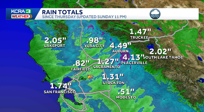
In the valley, rainfall totals ranged from about half an inch in Modesto to roughly 1.3 inches in both Sacramento and Stockton since Thursday. While those amounts were manageable for most lower elevations, parts of the foothills saw much heavier rain. Some foothill communities were placed under a flood advisory over the weekend, with storm totals climbing above 4 inches of rain.
Below are rain totals as of 11:00 p.m. April 12:
Hearst Owned
Rain totals since Thursday
The latest rain also helped improve water year standings. Sacramento has climbed back to around 85% of normal for this point in the season, while Stockton is now at 112% and Modesto at 109%.
Around the Lake Tahoe region, the storm delivered abundant rainfall before colder air helped change that moisture over to snow.
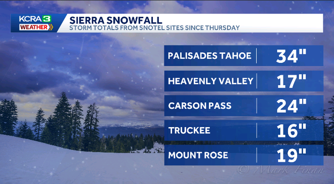
Below is a list of snow totals from local SNOTEL sites in the Sierra as of 10:00 p.m. April 12:
Hearst Owned
Snow totals since Thursday
In Truckee, the SNOTEL site has recorded 16 inches of snow since Thursday. Closer to the Sierra summits, snowfall totals were even more impressive. Palisades Tahoe picked up nearly 3 feet of snow, while SNOTEL sites at Carson Pass and Heavenly Valley each reported around 2 feet. Mount Rose measured close to a foot and a half.
While storm impacts significantly subsided early Monday morning, the Sierra is not completely done with this system yet. A few more showers are expected through Monday as the storm wraps moisture back into the mountains from the northeast.
Conditions are improving for the valley, but the Sierra will continue to see lingering impacts a bit longer as this Spring season storm system finally pulls away.
REAL-TIME TRAFFIC MAP
Click here to see our interactive traffic map.
TRACK INTERACTIVE, DOPPLER RADAR
Click here to see our interactive radar.
DOWNLOAD OUR APP FOR THE LATEST
Here is where you can download our app.
Follow our KCRA weather team on social media
Meteorologist Tamara Berg on Facebook and X.Meteorologist Dirk Verdoorn on FacebookMeteorologist/Climate Reporter Heather Waldman on Facebook and X.Meteorologist Kelly Curran on X.Meteorologist Ophelia Young on Facebook and X.
Watch our forecasts on TV or online
Here’s where to find our latest video forecast. You can also watch a livestream of our latest newscast here. The banner on our website turns red when we’re live.
We’re also streaming on the Very Local app for Roku, Apple TV or Amazon Fire TV.
See more coverage of top California stories here | Download our app | Subscribe to our morning newsletter | Find us on YouTube here and subscribe to our channel