
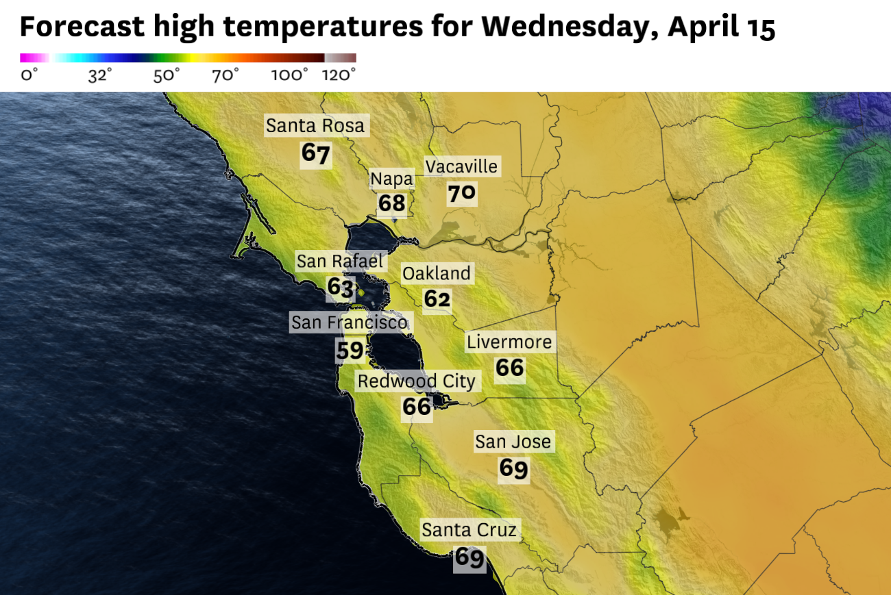
Wednesday will be the coolest and cloudiest day of the week around the Bay Area.
Baron/Lynx Wednesday will be cloudy, cool and breezy across the Bay Area, with highs mostly in the low to mid-60s and gusty west winds up to 20 mph.Some regions may see pockets of drizzle Wednesday evening, but most areas will remain dry with overnight lows dropping into the 40s.Sunshine and warmer temperatures are expected to return Thursday and Friday.
The weather is doing a lot of shuffling this week. Tuesday started cloudy and cool, but it ended with sunshine and seasonable temperatures. Wednesday will stay cloudy, cool and breezy, before a switch back to sunny and warmer conditions on Thursday and Friday.
Article continues below this ad
The atmosphere above our heads remains charged up, amplified and in a variable state. Just take one look at the weather variability across the country this week. The East Coast is baking, severe weather is popping up in the Midwest, and the West Coast is stormy and cool.
Locally, Wednesday is likely to be the gloomiest day of the week, especially in San Francisco. We’ll awake to a layer of clouds spread across the entire Peninsula and much of the rest of the region. Winds will be blowing onshore from the start, strengthened by an approaching cold front dropping in from the north.
That front and the onshore flow should generate a few pockets of drizzle on Wednesday evening, mainly in the Marin Headlands. But for the rest of us it will mostly mean cloudy skies, cool temperatures and a bit of wind.
San Francisco Chronicle Logo
Make us a Preferred Source to get more of our news when you search.
Add Preferred Source
Highs in San Francisco should top out around 60 degrees, while the rest of the Bay Area will range from the low to mid-60s. And the gusty west winds won’t help.
Article continues below this ad
The good news about a fluid weather pattern is that nothing stays the same for very long. Thursday will feel like a different day entirely. The wind direction switches to the northeast, bringing sunshine and warmer temperatures.
That trend should continue into the start of the weekend. But in keeping with the theme, another change is in the works for the second half of the weekend, and this one could bring another storm system and meaningful rain to the region.
Wednesday breakdown
San Francisco: Clouds will be layered across the city in the morning and they are unlikely to dissipate, especially west of Twin Peaks and along the Presidio shoreline. Downtown may sneak in spots of sunshine in the late afternoon, but temperatures will be cool across the board, ranging from the upper 50s at Ocean Beach to mid-60s in the Mission District. Winds will be gusty out of the west at 10 to 20 mph, with some higher gusts in the afternoon and evening. Skies will slowly clear overnight and winds will calm, with lows in the upper 40s.
North Bay: The morning starts cloudy across the North Bay valleys, but unlike San Francisco, you’re more likely to see some clearing by the afternoon. Petaluma, Novato, San Rafael and Napa all should reach the mid- to upper 60s, while Santa Rosa edges up to around 70. West winds will pick up through the afternoon, reaching 10 to 20 mph by later in the day. The night should clear out, but it will get chilly. Interior valleys should drop into the upper 30s to low 40s.
Article continues below this ad
East Bay: Along the bayshore, Oakland and Fremont should stay socked in for most of the day under mostly cloudy skies. Highs will reach the mid-60s, though there will be some breaks of sun late. Concord, Walnut Creek, Pleasanton, and Antioch all will start cloudy but get some clearing by the afternoon as the marine layer thins over the hills. Highs should push into the upper 60s. Winds will be breezy along the bay at 10 to 20 mph, less so inland. Overnight, lows should drop into the low to mid-40s inland, while Oakland hangs around 50 degrees.
Pacific Coast and Peninsula: The Peninsula and coastside will spend most of the day under gray skies. Pacifica and Half Moon Bay should barely crack 60 degrees, with clouds hanging tough all day and northwest winds at 10 to 20 mph keeping things cool. Across the Peninsula, it will be a bit warmer, but not much clearer. Some spots of sunshine should break out in the afternoon, with South San Francisco and SFO topping out in the low 60s and Redwood City pushing into the upper 60s. West winds will increase through the afternoon, pushing 10 to 20 mph with higher gusts, especially at SFO. Overnight, it will stay cloudy at the immediate coast with some clearing elsewhere. Lows will be in the 40s for most with diminishing winds.
South Bay: The South Bay gets the gentlest version of the day’s less than ideal weather. Morning clouds and patchy fog should give way to partial clearing by the afternoon, with San Jose and Mountain View reaching the upper 60s. Farther south, Gilroy and Morgan Hill will push toward the upper 60s to near 70 degrees with light northwest winds at 5 to 15 mph. Overnight should be mostly clear and cool with temperatures dropping into the low 40s.