
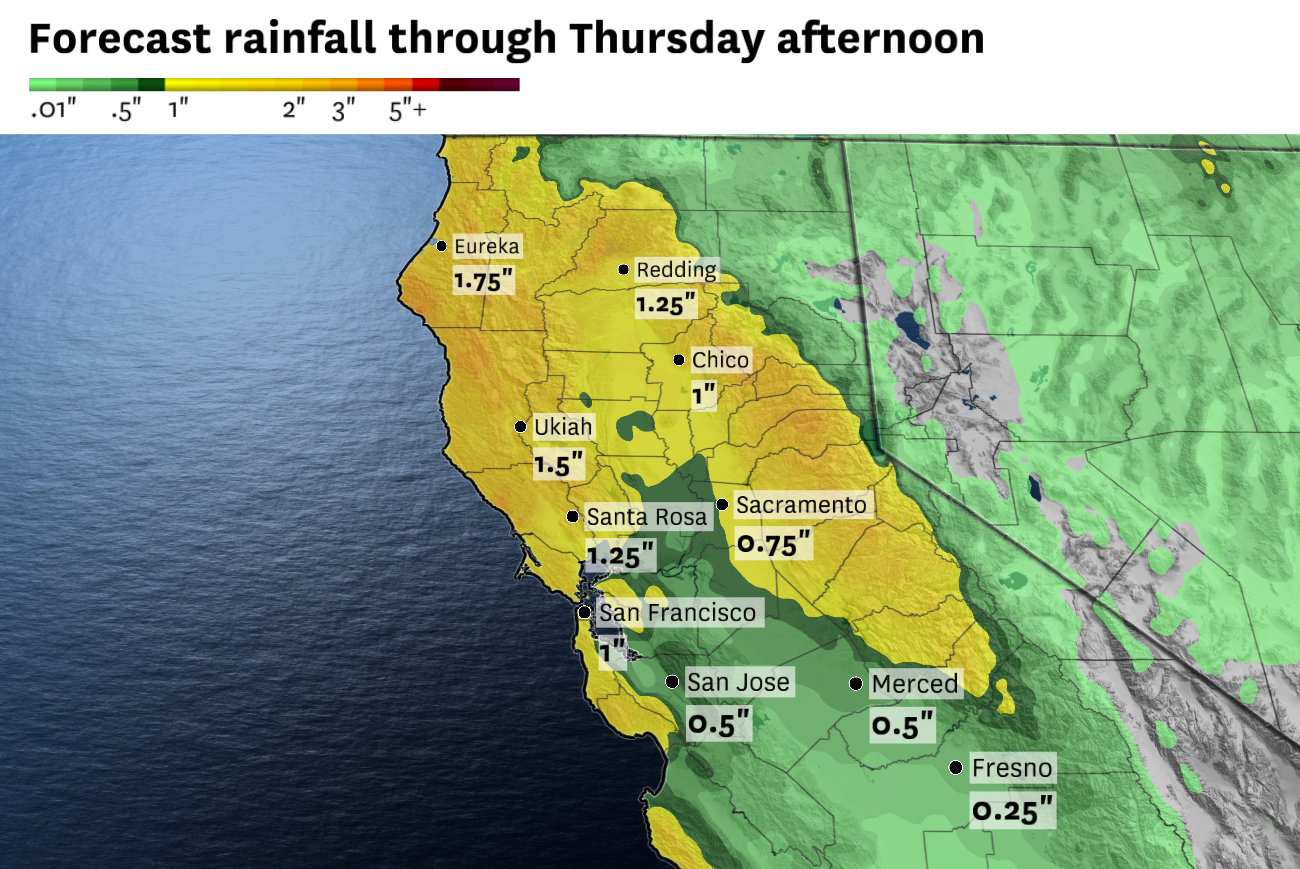
The National Weather Service forecasts 0.5 to 2 inches of rain across the Bay Area and Sacramento Valley from Monday through Thursday afternoon, with most of it expected to accumulate early in the week as a Pacific storm spins toward the region. Snow is anticipated at elevations above 6,000 feet in the Sierra Nevada.
Baron/Lynx
The dry winds whipping the Bay Area have kicked off a warming trend that will bring above-normal high temperatures through Saturday — but the next chance of wet weather isn’t far away.
By Sunday, clouds and winds are predicted to increase as a Pacific storm nudges toward Northern California. Precipitation chances will enter the forecast Monday, with rain and mountain snow probably sticking around through at least Wednesday.
Article continues below this ad
The system will have many similarities to the weekend storm that generated unusually large April rain and snow totals, but also some differences.
It looks to be a slow-moving low-pressure system cut off from the guiding winds of the jet stream, like the previous storm. Rainfall totals are difficult to forecast for cutoff low-pressure systems because they can linger for days at a time. Currently, 0.5 to 2 inches of rain is expected across most of Northern California from Monday through Wednesday.
A low-pressure system cut off from the jet stream is forecast to spin off the California coast on Monday. It may linger offshore for many days, keeping precipitation in the forecast through midweek, but a quick inland shift would end rain and snow chances sooner.
Baron/Lynx
“If the cutoff low lingers offshore, rather than progressing inland, that may allow the storm to overperform slightly and see higher amounts of rain across the region,” the National Weather Service said.
San Francisco Chronicle Logo
Make us a Preferred Source to get more of our news when you search.
Add Preferred Source
Rain and snow will favor Northern California, with Southern California probably only receiving light precipitation totals from the tail end of the system.
Article continues below this ad
Similar to last weekend, the storm is expected to tap into cold air and bring snow to the Sierra Nevada when it eventually pivots inland.
The freezing line is forecast to drop to around 6,000 feet Tuesday, low enough for snow in Tahoe, but it won’t be as low as last weekend, when heavy precipitation brought slushy accumulations as low as 4,000 feet. A foot is possible at Donner Summit by Wednesday morning, with about half that amount in Truckee, Tahoe City and South Lake Tahoe, though forecast totals will fluctuate ahead of the storm.
Unlike the recent rainmaker that was preceded by days of severe thunderstorms in the Central Valley, next week’s system won’t have a humid, unsettled air mass ahead of it.
Dry air ahead of the storm will limit the potential for showers until a cold front arrives Monday. The onset of precipitation will probably be triggered by an organized rain band sweeping across the Bay Area and eventually the Sacramento Valley on Monday, though it may be delayed until Monday night or Tuesday if the system slows down.
Thunderstorms may be in the mix behind the cold front, particularly Tuesday, but Wednesday’s chances for wet, unsettled weather depend on just how long the low-pressure system sticks around. These pesky cutoff lows frequent California in spring and still carry enough moisture to trigger thunderstorms and occasionally tornadoes, especially in the Central Valley. A tornado briefly touched down in Tehama County on Sunday, but no damage was reported.
Article continues below this ad
Weekend breakdown
San Francisco: Sunshine will dominate Friday with continued breezes out of the northeast, becoming northwesterly in the afternoon. Highs will be in the upper 60s to low 70s. Winds are expected to relax Saturday, allowing patchy fog to reform in the morning before partly to mostly sunny skies emerge by afternoon. Highs will be in the mid-60s at the coast and upper 60s east of Twin Peaks. Increasing clouds Sunday will cap temperatures in the mid- to upper 60s. There’s a slight chance of rain by Monday morning. Overnight lows will be around 50 degrees all weekend.
North Bay: Solano County and the Mayacamas Mountains will remain gusty Friday morning before winds relax in the afternoon. Highs will be in the low to mid-70s in Santa Rosa, San Rafael, Sonoma, Napa, Vallejo, Fairfield and Vacaville. Coastal areas will remain in the mid- to upper 60s. A few passing clouds are possible in the evening, otherwise skies will be clear. Overnight lows will be in the 40s.
Temperatures Saturday are forecast to rise a couple degrees from Friday’s highs, with calm winds and a mix of sun and clouds. Sunday will be a transition day as the dry, warm weather slowly fades and clouds increase ahead of the Pacific storm. It probably won’t rain, but a slight shift in the system’s timing could bring precipitation to Sonoma and Marin counties by the late evening and overnight. Highs will drop about 5 degrees to the upper 60s to low 70s. Lows will probably be more mild, around 50 degrees.
East Bay: Breezy conditions will persist Friday morning before winds slowly relax in the afternoon. Highs will be in the low to mid-70s under sunny skies. Lows will be in the upper 30s to mid-40s. Areas west of the Caldecott Tunnel may awake to patchy fog Saturday morning, a sign of a cooler day ahead. Highs will be in the upper 60s in Richmond, Berkeley, Oakland and Alameda and the low 70s in Hayward and Fremont. Antioch, Concord, Walnut Creek, Dublin and Livermore should reach the mid-70s. A mix of sun and clouds is expected with a light to moderate afternoon bay breeze. Lows will be in the upper 40s to mid-50s.
Article continues below this ad
The approaching Pacific storm will promote a cooler, overcast day Sunday as mid- to high-level clouds increase ahead of the system. No rain is expected during the day, though if the storm speeds up it could bring some light showers after midnight. Highs will depend significantly on the extent of cloud cover and exact wind direction, but will probably be in the 60s west of Caldecott Tunnel and the low 70s to the east. Lows will be in the upper 40s to mid-50s.
Pacific Coast and Peninsula: Clear skies Friday will make for the warmest day of the Friday-to-Sunday stretch in Daly City, Pacifica and Half Moon Bay, with highs in the mid- to upper 60s. The Highway 101 corridor will see highs in the upper 60s to low 70s on both Friday and Saturday. Morning fog Saturday should give way to partly sunny skies in the afternoon as the beaches cool off to the low to mid-60s. Overnight lows will be in the mid- to upper 40s.
Increasing clouds Sunday will be accompanied by breezy conditions as winds turn out of the south as the storm approaches. Highs will probably be capped in the 60s everywhere, though if the storm slows down, Redwood City could reach 70 degrees. Winds will increase further overnight, keeping lows around 50 degrees, with a slight chance of rain by daybreak Monday.
South Bay and Santa Cruz: Each passing day will become cloudier, with clear skies Friday, partly sunny weather Saturday and mostly cloudy conditions Sunday. High temperatures are expected to fluctuate only by a few degrees in the Santa Clara Valley, with highs in the 70s through Sunday and Saturday likely to be the warmest day. Sunday will be the coolest day in Santa Cruz County, with highs in the mid- to upper 60s. Otherwise highs will be in the low to mid-70s. Northerly breezy Friday will give way to calm conditions Saturday before southerly winds ramp up Sunday. Overnight lows will be in the mid- to upper 40s through the weekend, with a slight chance of rain Sunday night.
Article continues below this ad