
Northern California forecast: Timeline for thunderstorms and Sierra snow
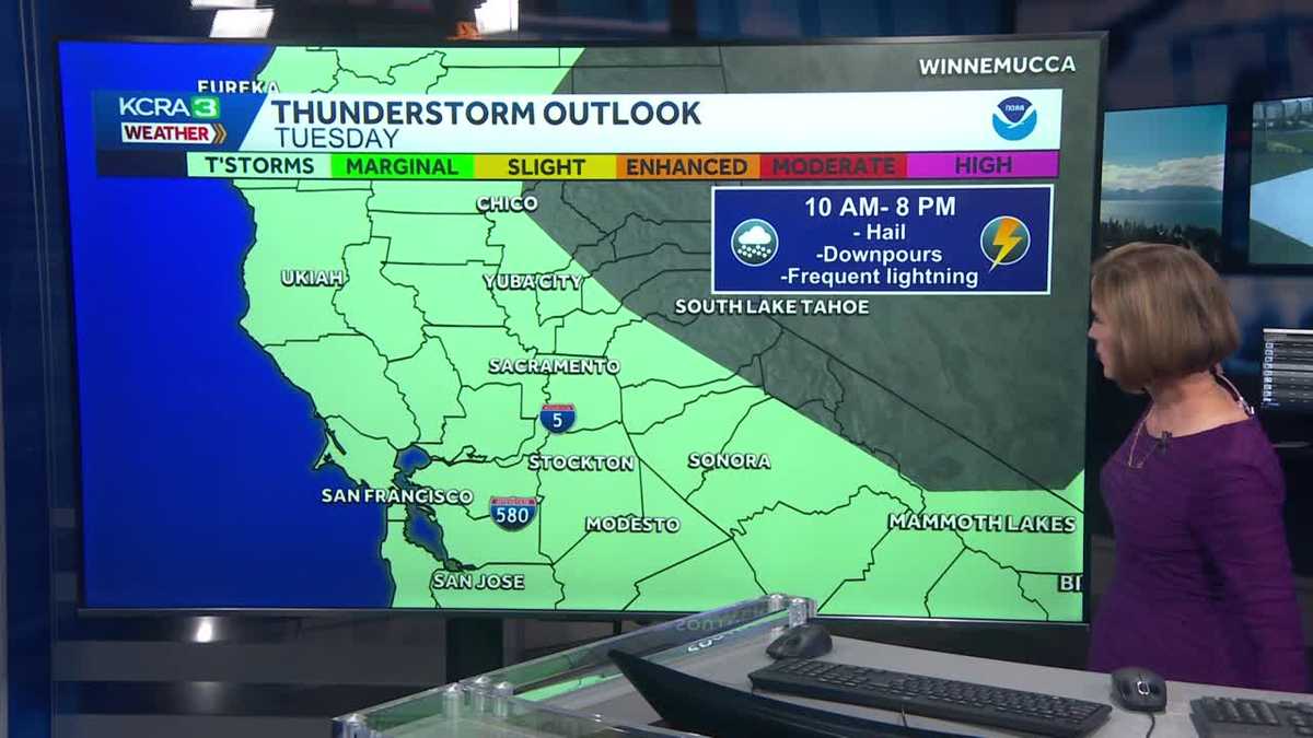
DOWNTOWN SACRAMENTO METEOROLOGIST HEATHER WALDMAN TRACKING ALL OF IT. YEAH, A FEW SPRINKLES SO FAR. MAYBE JUST ENOUGH TO KIND OF MOVE AROUND THE POLLEN ON YOUR WINDSHIELD. DON’T WORRY. WE GOT SOME STEADIER STUFF COMING IN. IN FACT, THIS IS FILLING IN REALLY NICELY ALONG INTO THE WEST OF I-5, ESPECIALLY IN THE NORTHERN END OF THE VALLEY. THIS IS LIGHT RAIN. THERE’S NO THUNDER OR LIGHTNING WITH IT. THERE’S NOT MUCH IN THE WAY OF WIND WITH IT. IT’S JUST REGULAR OLD CALL, A GARDEN VARIETY RAIN, BUT IT’S ALL MOVING EASTWARD AS WE GO THROUGH THIS EVENING. SO IF YOU’VE GOT DINNER PLANS, IF THE KIDS HAVE EVENING ACTIVITIES, IF YOU’RE GOING SOMEWHERE LATER ON TONIGHT, HAVE THE UMBRELLA, HAVE THE RAIN JACKET, EVEN IF IT’S NOT RAINING WHERE YOU ARE RIGHT NOW, IT WILL BE SOON. 24 HOUR RAIN TOTALS CLEAR LAKE HAS ALREADY PICKED UP CLOSE TO 4/10 OF AN INCH OF RAIN. MOST OF THAT THIS AFTERNOON. VACAVILLE NOW HAS SOME MEASURABLE RAINFALL. SAN FRANCISCO JUST UP OVER A 10TH OF AN INCH OF RAIN. NOTHING MEASURABLE IN SACRAMENTO, STOCKTON OR MODESTO. YET. THAT WILL BE CHANGING TONIGHT. HERE’S THE 12 HOUR TIMELINE. WE’LL SEE SOME LIGHT RAIN SHOWERS OVER THE NEXT COUPLE OF HOURS. I DON’T THINK THE THE HEAVIER RAIN REALLY GETS GOING UNTIL ABOUT 9 OR 10:00 THIS EVENING, BUT ONCE IT GETS HERE, IT’S GOING TO STAY HERE FOR A LITTLE WHILE. SO IT’S A GOOD DRINK OF WATER FOR THE LAWNS. ANY GARDEN PLANTS THAT YOU HAVE OUTSIDE. AND OF COURSE, GET THAT FREE CAR WASH IN THE MIX AS WELL TOMORROW AFTERNOON ESPECIALLY. BUT THIS COULD REALLY BEGIN LATE MORNING. THE CHANCE FOR SOME THUNDERSTORMS ANYWHERE FROM THE BAY AREA INTO THE FOOTHILLS. THAT’S WHAT THAT AREA OF GREEN SHADING REPRESENTS. STORMS GOING TO BE ISOLATED. SO NOT EVERYBODY SEES ONE, BUT 1 OR 2 COULD ONCE AGAIN DROP SOME SOME HAIL, SOME FREQUENT LIGHTNING AND SOME HEAVIER DOWNPOURS. IT’S NOT TO SAY THAT EVERYBODY’S GOING TO EXPERIENCE THAT WEATHER. WE JUST WANT YOU TO BE HEADS UP. IF YOU’RE GOING TO BE OUTDOORS ANYWHERE BETWEEN LUNCHTIME AND CLOSER TO SUNSET. ONCE THE SUN GOES DOWN, WE KIND OF LOSE THE ENERGY FOR SOME OF THOSE THUNDERSTORMS. BUT THIS IS 930 THIS EVENING. THAT WILL BE A GOOD SOAKING RAIN MOVING THROUGH RIGHT ALONG. I-5 MAY NOT BE RAINING ALL THAT HEAVILY YET IN THE FOOTHILLS. SO IF YOU GO TO BED TONIGHT AND IT’S NOT RAINING YET, DON’T WORRY, ALL OF THIS IS INCHING YOUR WAY OVERNIGHT TONIGHT. SO BY 6:00 IN THE MORNING IT IS GOING TO BE A STEADY RAIN ALONG HIGHWAY 49. RAIN IS GOING TO START TO BREAK UP IN THE VALLEY, BUT ROADS ARE GOING TO BE WET FOR THE MORNING COMMUTE. BE READY FOR THAT. KIDS MAY WANT RAIN BOOTS HEADED TO SCHOOL. WE’LL ALSO LIKELY BE INTO SOME CHAIN CONTROLS ON 80, 50, AND 88 BY THE TIME THE SUN COMES UP ON TUESDAY MORNING. THIS IS MIDDAY ON TUESDAY, SO RIGHT AROUND LUNCHTIME, NOTICE HOW THE RAIN BECOMES A LITTLE BIT MORE ISOLATED, BUT A LITTLE BIT MORE INTENSE. THESE ARE THOSE THUNDERSTORMS PICKING UP AND 1 OR 2 OF THEM COULD PRODUCE SOME HAIL, SOME FREQUENT LIGHTNING. HARD TO PINPOINT EXACTLY WHERE, BUT ANYWHERE IN THE VALLEY, THE FOOTHILLS AND THE BAY AREA. WE JUST WANT YOU TO BE READY FOR THAT. WE’LL BE TRACKING IT FOR YOU HERE LIVE TOMORROW EVENING. STILL A FEW THUNDERSTORMS HANGING ON. STILL SEEING SNOW. STILL SEEING CHAIN CONTROLS IN THE SIERRA. BY WEDNESDAY. A FEW SHOWERS LEFT OVER. PROBABLY STILL CHAIN CONTROLS IN THE MOUNTAINS EARLY ON, BUT THE REST OF THE DAY DRIES OUT VERY QUICKLY. IT’S GOING TO BE A MUCH EASIER DAY FOR DRIVING IN THE MOUNTAINS COMPARED TO WHAT WE’RE TALKING ABOUT TOMORROW. TOMORROW IS A DAY WHERE YOU CAN GET UP AND OVER THE SUMMITS. IT’S JUST GOING TO TAKE YOU A WHILE. MAKE SURE YOU’VE GOT THE CHAINS AND CABLES WITH YOU BY WEDNESDAY. OUR AREA OF LOW PRESSURE IS OFF TO OUR EAST. IT’S STILL CLOSE ENOUGH THAT WE’LL SEE SOME MOUNTAIN SHOWERS IN THE MORNING, BUT THE REST OF WEDNESDAY, THURSDAY, FRIDAY ALL LOOK DRY. THE WEEKEND FORECAST DEPENDS ON WHERE THAT LITTLE AREA OF LOW PRESSURE ENDS UP. RIGHT NOW, IT DOESN’T LOOK LIKE IT HAS MUCH MOISTURE WITH IT, BUT JUST BECAUSE THE LIFT IT WILL BRING, THERE COULD BE SOME MOUNTAIN SHOWERS ON SATURDAY AND SUNDAY. THE VALLEY AND FOOTHILLS LOOK DRY BUT RELATIVELY COOL, ESPECIALLY COMPARED TO WHERE WE WERE THIS PAST WEEKEND. TEMPERATURES TOMORROW, BARELY GETTING INTO THE 60S IN THE SACRAMENTO VALLEY. WE’LL STAY IN THE LOW 50S IN AUBURN AND PLACERVILLE. THIS IS WHAT THE SEVEN DAY LOOKS LIKE FOR THE FOOTHILLS AND THE MOUNTAINS. TEMPERATURES INCREASING FOR THE END OF THE WEEK. AGAIN, A FEW SHOWERS POSSIBLE IN THE MOUNTAINS DOESN’T LOOK LIKE ANYTHING IN THE WAY OF DISRUPTIVE SNOW. IT
Meteorologist/Climate Reporter
Another round of wet weather is underway in Northern California.The region can expect steady rain on Monday evening. The Valley could pick up half an inch to an inch of rain by Tuesday morning, with higher amounts expected for the Foothills. Chain controls will be likely overnight. (Check the latest highway conditions here.)Our weather team is calling Tuesday an Impact Day for rain, the possibility of thunderstorms and Sierra snow that could slow travel.The Valley will start with light rain in the morning. This will turn into scattered showers and a few heavy thunderstorms in the afternoon and evening. The thunderstorms are expected anywhere from the coast to the Foothills from late morning through the evening. While the storms will not be as strong as those that impacted the region a week and a half ago, a few cells are expected to drop some hail and cause frequent lightning.Sierra travel will likely be delayed throughout the day because of snow. The snow level will start around 6,500 feet and then drop closer to 5,000 feet by the evening. Accumulation is likely all day. Most summit locations will pick up close to a foot of new snow by Tuesday night.SEE RAIN TOTALS BELOWREAL-TIME TRAFFIC MAPClick here to see our interactive traffic map.TRACK INTERACTIVE, DOPPLER RADARClick here to see our interactive radar.DOWNLOAD OUR APP FOR THE LATESTHere is where you can download our app.Follow our KCRA weather team on social mediaMeteorologist Tamara Berg on Facebook and X.Meteorologist Dirk Verdoorn on FacebookMeteorologist/Climate Reporter Heather Waldman on Facebook and X.Meteorologist Kelly Curran on X.Meteorologist Ophelia Young on Facebook and X.Watch our forecasts on TV or onlineHere’s where to find our latest video forecast. You can also watch a livestream of our latest newscast here. The banner on our website turns red when we’re live.We’re also streaming on the Very Local app for Roku, Apple TV or Amazon Fire TV.See more coverage of top California stories here | Download our app | Subscribe to our morning newsletter | Find us on YouTube here and subscribe to our channel–KCRA 3’s Daniel Macht contributed to this story.
Another round of wet weather is underway in Northern California.
The region can expect steady rain on Monday evening. The Valley could pick up half an inch to an inch of rain by Tuesday morning, with higher amounts expected for the Foothills.
Chain controls will be likely overnight. (Check the latest highway conditions here.)
Our weather team is calling Tuesday an Impact Day for rain, the possibility of thunderstorms and Sierra snow that could slow travel.
The Valley will start with light rain in the morning. This will turn into scattered showers and a few heavy thunderstorms in the afternoon and evening.
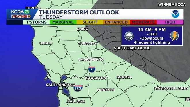
The thunderstorms are expected anywhere from the coast to the Foothills from late morning through the evening. While the storms will not be as strong as those that impacted the region a week and a half ago, a few cells are expected to drop some hail and cause frequent lightning.
Sierra travel will likely be delayed throughout the day because of snow.
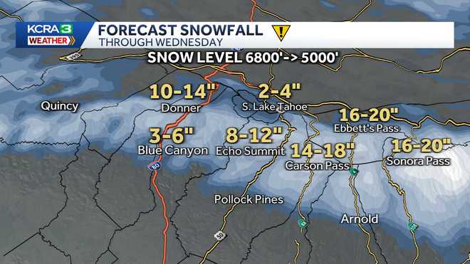
The snow level will start around 6,500 feet and then drop closer to 5,000 feet by the evening.
Accumulation is likely all day. Most summit locations will pick up close to a foot of new snow by Tuesday night.
SEE RAIN TOTALS BELOW
REAL-TIME TRAFFIC MAP
Click here to see our interactive traffic map.
TRACK INTERACTIVE, DOPPLER RADAR
Click here to see our interactive radar.
DOWNLOAD OUR APP FOR THE LATEST
Here is where you can download our app.
Follow our KCRA weather team on social media
Meteorologist Tamara Berg on Facebook and X.Meteorologist Dirk Verdoorn on FacebookMeteorologist/Climate Reporter Heather Waldman on Facebook and X.Meteorologist Kelly Curran on X.Meteorologist Ophelia Young on Facebook and X.
Watch our forecasts on TV or online
Here’s where to find our latest video forecast. You can also watch a livestream of our latest newscast here. The banner on our website turns red when we’re live.
We’re also streaming on the Very Local app for Roku, Apple TV or Amazon Fire TV.
See more coverage of top California stories here | Download our app | Subscribe to our morning newsletter | Find us on YouTube here and subscribe to our channel
–KCRA 3’s Daniel Macht contributed to this story.