
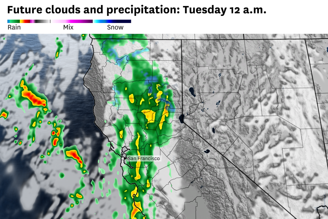
Another round of moderate to heavy rain will move through the Bay Area overnight.
Baron/Lynx
6 p.m. update: The heaviest rain of the storm is moving through the Bay Area this evening. Pockets of heavy rain will continue through about 8 p.m., with rain showers becoming more scattered through midnight. Another round of rain will start to organize over the South Bay later this evening, eventually spreading across San Francisco, the Peninsula and East Bay overnight.
Some of the heaviest rainfall totals this evening have been in the Marin headlands and Oakland hills, where upwards of an inch of rain has fallen in just a few hours. Heavy rain from earlier in the day brought about 0.5 to 1 inch of rain, from Novato up to Santa Rosa. San Francisco has picked up close to a half an inch as of 6 p.m on Monday evening.
Article continues below this ad
A spring storm will bring steady rain, gusty coastal winds and a messy evening commute to the Bay Area on Monday, kicking off a multiday system that will bring several days of showers to the Bay Area, dump heavy snow on the Sierra and spark thunderstorms in the Central Valley through midweek.
San Francisco Chronicle Logo
Make us a Preferred Source to get more of our news when you search.
Add Preferred Source
Rain will arrive in the North Bay toward the end of the Monday morning commute, spreading south and east through the day. Most Bay Area neighborhoods can expect 0.3 to 0.5 of an inch by Monday night, with 1 to 2 inches in the coastal hills and Santa Cruz Mountains. South-to-southwest wind gusts of 30 to 40 mph are likely along the San Francisco and Peninsula coasts during the morning.
The storm is the leading edge of a slow-moving upper low parked off the California coast, a setup that will keep showers and cool temperatures in the forecast through Wednesday.
Article continues below this ad
Rainfall timing
Forecast models still disagree on exact timing, so these windows could shift by a few hours.
The North Bay will see rain first, with light showers possible before dawn and steady rain breaking out across Sonoma, Marin and Napa counties between 7 and 9 a.m. Santa Rosa, Petaluma and Napa should plan for a wet end to the morning commute. Rain will pick up again in intensity in the afternoon and evening in the North Bay.
San Francisco, the Peninsula and inner East Bay cities including Oakland, Berkeley and Richmond will see rain moving in the early morning, with steadier rain building in the afternoon. The heaviest rain is likely to fall between 2 p.m and 8 p.m., making for a wet evening commute.
The South Bay, including San Jose and the Santa Clara Valley, will be the last to see rain, with showers arriving in the late morning and continuing into the evening. The Santa Cruz Mountains will act as a rain shadow, cutting into totals, and amounts will be lighter than points north.
Article continues below this ad
How much rain to expect
Monday’s rain should be a soaking, not a washout. Despite the slow movement of the cold front, it should clear the region by the evening, keeping urban and flash flood concerns low.
The urban cores of San Francisco, Oakland and San Jose should see 0.25 to 0.5 of an inch of rain through Monday night, with South Bay valleys on the lighter end of that range. The North Bay valleys, including Santa Rosa, Petaluma and Novato, should pick up close to an inch of rain. The East Bay hills above Oakland and Berkeley will probably see totals over an inch, while the coastal hills, Mount Tamalpais, the Peninsula coast range and the Santa Cruz Mountains should end up with 1 to 2 inches by Monday evening.
Additional rain showers and some isolated thunderstorms are in the mix for the Bay Area on both Tuesday and Wednesday.
Coastal winds peak in the morning
South-to-southwest winds will have ramped up over the coastal waters overnight and push onshore by early Monday. The San Francisco and Peninsula coasts will see the strongest gusts, with widespread 30 to 40 mph gusts between 7 a.m. and noon.
Article continues below this ad
Southerly wind gusts should ease across the Bay Area by Monday afternoon after peaking at 30 to 40 mph in the morning.
Baron/Lynx
Daly City, Pacifica and the San Francisco International Airport corridor will probably see gusts over 40 mph, which could mean flight delays in the morning. Winds will ease through the afternoon but stay breezy from the west and southwest region-wide.
Sierra snow and valley thunderstorms build through midweek
This will be a cold storm system for April and should bring significant snow to the Sierra Nevada. A winter storm watch is in effect for the Sierra above 5,000 feet from late Monday night through Wednesday afternoon. Snow levels will start near 6,500 feet Tuesday morning, drop to 5,500 feet by Tuesday night and fall to 4,500 feet by Wednesday.
Article continues below this ad
Storm totals are forecast at 5 to 10 inches of snow around Lake Tahoe and 12 to 18 inches at higher elevations, including the passes. Chain controls and travel delays are likely on Interstate 80 and Highway 50 Tuesday and Wednesday.
Forecast snow totals through Tuesday evening show the heaviest accumulations along the Sierra crest, with 1 to 2 feet likely at pass level and deeper totals above 8,000 feet.
OpenSnow
A thunderstorm threat is also shaping up in the Central Valley and eastern Bay Area on Tuesday, with the possibility of small hail, gusty winds and, in rare cases, brief funnel clouds or weak tornadoes. The risk zone includes eastern Contra Costa, Alameda and Napa counties. The thunderstorm threat continues for the Central Valley and Sierra into Wednesday as the core of the upper low swings through.