
High-resolution model guidance shows a band of moderate to heavy rain sweeping across the Bay Area around 11 a.m. Tuesday
Baron/Lynx
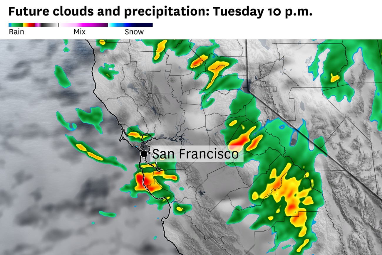
A second round of heavy rain should move through the Bay Area on Tuesday morning, making for a wet start to the day. The afternoon will feature scattered showers, more downpours and perhaps even a rumble of thunder before the storm’s focus shifts east to the Central Valley and Sierra Nevada.
Monday’s rain came with the passage of a cold front. Tuesday’s rain comes from the same weather system — an upper-level low still parked off the Northern California coast — but the character will shift from steady frontal rain to heavier bursts.
Article continues below this ad
The timing of the morning round is relatively uncertain. The commute should start dry for most of the Bay Area, but expect widespread rain across San Francisco, the Peninsula, Oakland and Berkeley from about 9 a.m. through 1 p.m. The North Bay will see showers continuing from the overnight hours through the morning, with amounts tapering by midday. The South Bay and Santa Clara Valley will see lighter and more scattered showers.
High temperatures Tuesday will run roughly 10 degrees below normal across the Bay Area, holding in the upper 50s to low 60s
Baron/Lynx
Bay Area showers will turn hit-or-miss in the afternoon as the cold core of the upper-level low arrives overhead. The best chances for showers and downpours will be over the Santa Cruz Mountains, the East Bay hills and the North Bay hills, where stronger cells could produce gusty winds, small hail or a rumble of thunder.
San Francisco Chronicle Logo
Make us a Preferred Source to get more of our news when you search.
Add Preferred Source
Some sun breaks are likely along the San Francisco and Peninsula coasts by late afternoon as drier air works in between showers. But it will be noticeably cool on Tuesday, with most areas stuck in the upper 50s to mid-60s with breezy southwest winds extending through the afternoon.
Article continues below this ad
The Central Valley is the hot spot for afternoon thunderstorms on Tuesday. The National Weather Service puts the chance of thunderstorms at 30 to 45% across the valley, with heavy rain, small hail, gusty winds and frequent lightning the primary threats.
The weather in general is unlikely to be particularly severe. But with the center of the cold upper level low moving directly over the Sacramento Valley, some storm rotation could develop in stronger thunderstorm cells, bringing a low-end chance of a brief funnel cloud or weak tornado somewhere in the valley.
The Storm Prediction Center has placed much of Northern and Central California, including the Bay Area, under a general thunderstorm risk for Tuesday.
Baron/Lynx
The Sierra Nevada should see the biggest impacts from this storm. A winter storm warning is in effect above 5,000 feet from 2 a.m. Tuesday through 5 p.m. Wednesday. Snow levels will start near 7,000 feet Tuesday morning, drop to 4,000 to 5,000 feet by Tuesday night, and settle around 6,000 feet Wednesday.
Forecasters expect 12 to 18 inches of snow above 5,000 feet and more than 2 feet on the highest peaks, with snowfall rates of 1 to 2 inches per hour possible Tuesday into Tuesday night.
Article continues below this ad
Wind gusts of up to 75 mph are expected along the Sierra crest. Chain controls will likely be in place by Tuesday morning and continue into Wednesday morning, with slow travel expected on Interstate 80 and Highway 50 through Wednesday afternoon.
Tuesday breakdown
San Francisco: A round of moderate to heavy rain should push onshore in San Francisco sometime between 9 a.m. and noon, with some heavy downpours most likely across the Sunset, Richmond and other western neighborhoods. The rain should taper to scattered showers by midafternoon, and then skies could brighten briefly as drier air works its way in. Temperatures will be cool, with highs only in the upper 50s to around 60 degrees. Winds will be breezy out of the southwest at 15 to 20 mph. Rain showers will return overnight with mostly cloudy skies and temperatures in the 50s.
North Bay: A round of moderate to heavy rain should move through the North Bay between roughly 8 a.m. and 11 a.m., with the heaviest downpours most likely across Sonoma County and the Napa Valley. A few of these storms could produce brief gusty winds. Showers should taper to scattered activity by mid-afternoon, with a brief lull and some spots of sunshine in the afternoon. Temperatures will run well below normal, with highs only in the upper 50s across the valleys and low 50s along the coast near Point Reyes. Winds will be breezy out of the south-southwest at 10 to 20 mph. Another round of moderate to heavy showers will move in overnight with temperatures holding in the low 50s.
East Bay: Rain should push into the East Bay in the late morning hours, with the heaviest pockets of rain most likely across the inner East Bay (Berkeley, Oakland, Hayward) and the Diablo Valley (Walnut Creek, Concord, Martinez). The afternoon will bring scattered showers with cool temperatures and highs ranging from the mid-50s to around 60 degrees. Winds will be breezy from the southwest at 10 to 20 mph. More rain showers will move through overnight in the pre-dawn hours, with temperatures in the low 50s.
Article continues below this ad
Pacific Coast/Peninsula: Rain will move through the immediate coastline early on Tuesday morning. A line of moderate to heavy rain showers will spread across the rest of the Peninsula by mid-morning. Heavy downpours are most likely from Pacifica and Half Moon Bay inland through Daly City. The rain will lighten in the afternoon, with lingering showers possible over the coastal hills. Temperatures will be cool, with highs in the upper 50s along the Peninsula and low to mid 50s right along the coast. Winds will be breezy out of the southwest at 15 to 25 mph, with stronger gusts at the coast. Rain returns overnight with mostly cloudy skies and temperatures in the low 50s.
South Bay: Much of Tuesday morning should be dry, but steady rain is expected to move in just before noon. The heaviest showers will be in the Santa Cruz Mountains and Santa Clara Valley foothills. Showers will become scattered through midafternoon before tapering by early evening. Some sunshine may develop late. Temperatures will be cool, with highs in the upper 50s to around 60 degrees in Silicon Valley. Showers should redevelop across San Jose and Santa Clara in the predawn hours on Wednesday, with temperatures in the low to mid-50s.