
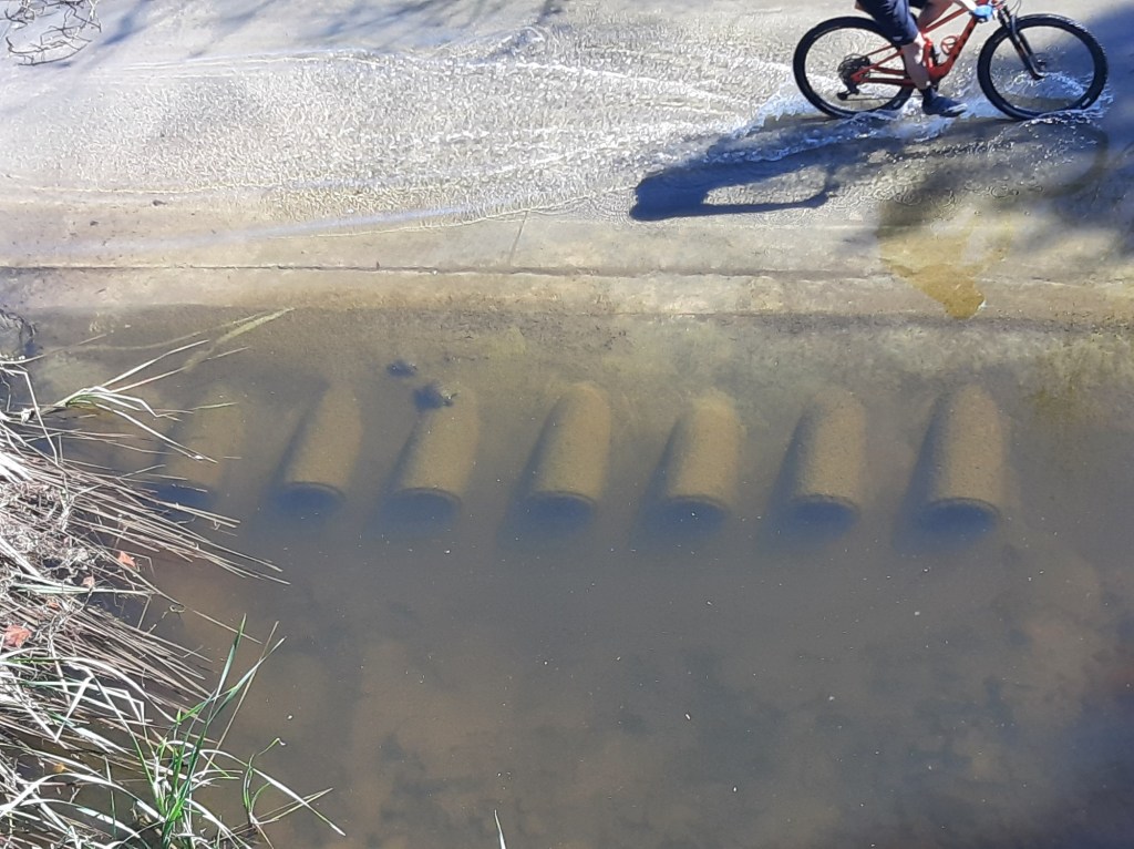
The city of San Diego continues to gather feedback as they pursue a project to fix a segment of the popular, well-used SR-56 bike path that is prone to flooding.
Last month, the advisory Carmel Valley Community Planning Board delayed its vote on the project, requesting that the city extend its outreach to gather input from the neighboring Palacio Del Mar and the cycling community. The city’s stormwater department presented a brief informational update at the board’s April 23 session and will potentially seek approval at next month’s meeting on May 28.
The 56 bike path corridor connects I-15 and I-5, serving as not only a critical component of the San Diego Regional Bike Network but also as a scenic spot for recreational riding, walking and running.
In Carmel Valley the targeted portion of the path goes under the Carmel Country Road bridge and comes out along a drainage pond before traveling along the edge of the Palacio neighborhood and linking back up alongside the freeway. Following any kind of rain event, water frequently tops the trail—in its submerged and slick state, it can be impassable or unsafe. The city has received numerous complaints over the last several years about the flooding, slippery conditions and cyclist falls.
The city’s proposed $3.8 million solution is to raise the bike path by two feet—the elevation will allow for the construction of six new box culverts below for the water to flow through. Safety railings will be added on top of the raised crossing.
Currently, the path is wet for about a third of the year, according to Kris Ekert, a senior civil engineer with the city’s stormwater department. With the improvements, dependent on storm activity, the city expects to get the pooling down to about one day after a two-year storm event, rainfall that occurs on average once every two years and has a 50% probability of occurring in a given year. However, the area is still intended to function as a floodway.
“The key benefit of the project is that its current condition is highly susceptible to any precipitation event at all. Whereas, if we improve the path, it will be far more useful,” Ekert said.
Following the planning board’s request, Ekert said they met with Palacio Del Mar HOA on April 22. The HOA board requested further aesthetic enhancements for the crossing and expressed concerns about bike speeds, the impact on the adjacent golf course, and on the turtles, the many non-native red-eared sliders who have made the drainage pond their home.
As more people have become aware of the project, there has been some pushback to the $3.8 million cost as an “egregious waste of money”. Others, like trail riders and representatives from the San Diego Bike Coalition, support the project for its benefits, acknowledging the importance of uninterrupted bike paths. While there is an alternative to the path over the Carmel Country Road overpass, the beauty of the bike path is its safety, a protected path away from cars and distracted drivers.
At the April 23 meeting, longtime Carmel Valley resident Kevin Hainley restated his opposition to the city’s proposed solution as he believes it doesn’t address the larger issue of undergrowth in the Carmel Country floodway.
“Underneath Carmel Country Road you have water that stands for many, many weeks,” Hainley said. “We’ve got plant material, dead wood, debris and garbage blocking water from getting through.”
Hainley, who walks the path weekly with his mini horses Flash and Ziggy, disagrees with the estimate that the path is flooded 120 days a year but noted that after a major rain, the trail remains overtopped for a few weeks. He said over the past few years the standing water accumulating under the bridge has only increased due to the clogged conditions.
Representatives from the Palacio HOA expressed some of the same concerns about the brush buildup in the creek bed. They have made their own attempts to manage the channel, potentially doing some dredging so that water can flow under the bridge, however, the area is regulated by the California Coastal Commission, California Department of Fish and Wildlife, and the Army Corps of Engineers.
Ekert said with the project there will be some removal of sediment and vegetation but the floodway is intended to collect sediment and the area is meant to be a dense riparian habitat, created as mitigation for the construction of the highway.
“Dredging is not a permitable option,” Ekert said. “It’s pretty difficult if not impossible to get a permit to do dredging in this location.”
Ekert said the city still has more work to do on the project, including continued outreach with the HOA and efforts to shrink the $3.8 million price tag by taking a closer look at the assumptions used to estimate contingencies, permitting and construction escalation.
In addition to the planning board’s vote of concurrence, the city will require permits for the project from the California Coastal Commission, Fish and Wildlife, Army Corps of Engineers and the San Diego Regional Water Control Board. Ekert said they anticipate getting all permits by the end of the year and starting construction in 2027, targeting completion by mid-2028.
The planning board next meets on Thursday, May 28 at 7 p.m. at the Carmel Valley Library.