
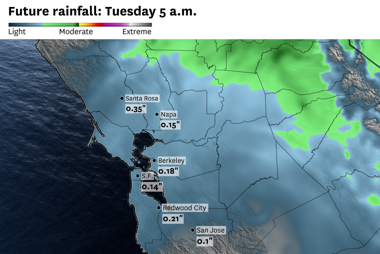
Forecast rainfall totals through Tuesday morning show the North Bay favored for the heaviest amounts. San Francisco and the South Bay should see far less.
Baron/Lynx
The Bay Area is in line for a shot of light rain Monday night and Tuesday morning, but the heaviest totals will fall well north of San Francisco. Santa Rosa, Napa and the surrounding hills could see up to half an inch, while most of the urban Bay Area will be lucky to pick up more than a tenth.
A low-pressure system has been hovering just off the coast of Central California all weekend, bringing consecutive days of below normal temperatures and cloudy skies. That low will slowly drift toward the southeast on Monday and Tuesday, taking about 36 hours for the center of the storm system to move from the Bay Area toward Los Angeles.
Initially, that means Monday will be another day filled with clouds and cool temperatures. But by Monday night, rain showers will develop on the “backside” of the storm system, moving in from the northeast — an atypical direction for Bay Area rain — and sliding southwest across the North Bay, San Francisco, the Peninsula, and parts of the East Bay through Tuesday morning.
Article continues below this ad
The North Bay is favored for the heaviest totals, with model guidance pointing to a 0.25 to 0.50 inch range from about Novato northward through Santa Rosa, including the Marin and Sonoma hills. The rest of the Bay Area should see considerably less. San Francisco, the Peninsula and the East Bay urban core are looking at a tenth of an inch or so. The South Bay is likely shut out entirely, with most spots seeing only drizzle, if anything.
The rest of Tuesday will serve as a slow transition away from the cool, cloudy and wet conditions toward drier and warmer conditions, at least for the interior North Bay, East Bay and South Bay. Clouds and cool temperatures will be harder to displace in San Francisco and around the bay itself.
San Francisco Chronicle Logo
Make us a Preferred Source to get more of our news when you search.
Add Preferred Source
By Wednesday, the upper level low will move into the Great Basin and southern Rockies. A ridge of high pressure will build in behind it, leading to warming and drying conditions across the region, including in the city itself.
Monday breakdown
San Francisco: Monday will be another cloudy and cool day in the city. Afternoon temperatures will peak in the low 60s in most neighborhoods, except Ocean Beach where they are likely to stay in the upper 50s. The marine layer should hold firm through much of the day, with the city likely staying gray from start to finish. Monday evening should stay dry, but as the storm system pivots south overnight, light rain and drizzle become possible across the city after midnight, with lows in the 50s.
Article continues below this ad
North Bay: It will be cloudy and cool through the day, with highs in the low to mid 60s in Santa Rosa, Napa and Petaluma. Rain chances will ramp up through the afternoon and evening, with showers becoming likely after sunset. The first measurable rain should arrive in Sonoma County by mid-evening before spreading south into Marin and Napa overnight. Most of the rain should fall between midnight and Tuesday sunrise.
East Bay: Cloudy and cool conditions will hold across the East Bay on Monday, with some afternoon clearing east of the Berkeley hills. Oakland, Berkeley and Richmond should see temperatures start out in the 50s, rising into the low to mid-60s by the afternoon, with clouds persisting all day. Inland in Concord, Walnut Creek and Livermore, skies will be a bit brighter and temperatures should rise into the mid-to upper 60s. Overnight, light rain becomes more likely, with the best chance for measurable totals after midnight in the East Bay hills.
Pacific Coast: The marine layer will keep the immediate coast locked under cloud cover all day on Monday. Highs in Half Moon Bay, Pacifica and Daly City will barely reach into the low 60s. Monday evening should remain dry, but a few light showers are possible overnight. Accumulations should be light, with most coastal communities picking up only a few hundredths of an inch by Tuesday morning.
Peninsula: Clouds and cool temperatures should rule the day along the Peninsula, especially from South San Francisco through San Mateo. Some partial afternoon clearing is possible around Redwood City. Temperatures will peak in the low to mid-60s. Some light rain showers should develop overnight, but most areas should see little to no accumulation, save for locations right along the bayshore where pockets of drizzle are likely.
Article continues below this ad
South Bay: Clouds and cool temperatures should give way to some sunshine by the afternoon in the South Bay. Temperatures will stay stuck in the mid to upper 60s in most spots. Overnight, rain showers should stay to the north of the region, with increasing clouds and temperatures in the low 50s.
Santa Cruz: The marine layer should keep Santa Cruz stuck in cloud cover for much of Monday. That should also keep temperatures in the mid-60s, with slightly warmer conditions in the Santa Cruz mountains. Overnight, the mountains are likely to pick up between 0.25 and 0.5 inches of rain from passing showers, with little to no accumulation expected along the coast.