
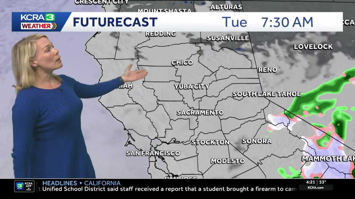
NorCal forecast: Showers ending Tuesday
Showers linger Tuesday, but skies clear overnight and temperatures soar heading toward the weekend
I’M REID BINION REPORTING. IT IS 419. TIME FOR ANOTHER CHECK ON OUR FORECAST AS WE TAKE A LIVE LOOK HERE OVER DOWNTOWN SACRAMENTO. LET’S HEAD BACK TO METEOROLOGIST TAMARA BERG AND THINGS ARE A LITTLE SOGGY AS WE KICK OFF YOUR TUESDAY AS TO BE EXPECTED. OF COURSE, WE HAD SOME PRETTY GOOD STEADY ROUNDS OF RAIN. NAVIGATE ACROSS NORCAL YESTERDAY, ESPECIALLY DURING THE AFTERNOON AND INTO THE EARLY EVENING. SO I KNOW ON MY DRIVE INTO THE OFFICE, THE ROAD, THE TRACK OUT THERE WAS PRETTY WET AND THERE WERE EVEN SOME PUDDLES OFF TO THE SIDE OF THE ROAD. TEMPERATURES ARE UNIFORM. LOOK AT THIS. WE’RE AT 53 DEGREES SACRAMENTO STOCKTON IN MODESTO. THIS IS A LIVE LOOK RIGHT NOW IN RANCHO CORDOVA, WHERE WE HAVE CLOUDY SKIES AND THE TRACK THERE ALONG 50. ALSO GOING TO BE SOGGY FOR MY EARLY RISERS, TAKING OFF ON A MORNING DRIVE. 33 RIGHT NOW IN SOUTH LAKE TAHOE. AND NOTICE THAT WITHIN THE LAST HOUR HERE, AS I TAKE YOU THROUGH THE DOPPLER REWIND, WE STILL HAVE EVEN A LITTLE BIT OF RAIN AND SNOW SHOWERS MIXING IN UP IN THE HIGHER ELEVATIONS, MAINLY ABOVE ABOUT 6000FT. SO EVEN A COUPLE OF FLAKES AROUND LAKE LEVEL, JUST NOT REALLY STICKING. BUT THEN IT STICKS AS YOU START TO GO UP ABOVE ABOUT 8000FT. YOU CAN SEE THIS NARROW BAND OF MOISTURE. IT’S REALLY SOUTH OF HIGHWAY 50. STOCKTON RIGHT AROUND MUCH OF SAN JOAQUIN COUNTY. STILL GETTING A BRIEF SHOWER. WE’VE HAD SOME HEAVIER BANDS OF RAIN, ESPECIALLY IN CALAVERAS COUNTY THIS MORNING. AND NOW YOU CAN SEE THAT THE EASTERN SIDE OF STANISLAUS COUNTY STILL SEEING JUST A BRIEF SHOWER. I DO ANTICIPATE THAT AS WE GET CLOSER TO SUNRISE. SO RIGHT AROUND THAT 7:00 HOUR, MOST OF THIS IS GOING TO BE WRAPPING UP. SO IT’S NOT GOING TO BE AN EVENT WHERE WE ARE KIND OF WAITING ON THE RAIN LIKE WE DID YESTERDAY. INSTEAD, WE’LL SEE CLOUDY, OVERCAST SKIES FOR THE FRONT HALF OF THE DAY. MAYBE A BRIEF SHOWER IN THE VALLEY UNTIL SUNRISE. AND THEN ONCE WE GET BEYOND DAYBREAK, LOOK AT THIS LUNCHTIME. WE’LL START TO SEE SOME SUNSHINE SNEAKING THROUGH THE CLOUDS AND EXPECT THAT WE WILL BE DRYING OUT FROM THERE. THE EXCEPTION WILL BE IN THE SIERRA, WHERE WE COULD STILL SEE A BRIEF SHOWER OR THUNDERSTORM THIS AFTERNOON. NOW, ONCE THIS PIECE OF ENERGY CONTINUES TO SLIDE OFF TO THE EAST, THAT WILL OPEN THE DOOR FOR SOME WARMING. IN FACT, WE’LL LOOK AT MOSTLY SUNNY SKIES DURING THE DAY TOMORROW. WE START THE WARMING TREND BY THE WEEKEND. I AM TRACKING 90 IN OUR FUTURE. PRETTY MUCH ALL OF THAT INFLUENCED BY THIS AREA OF HIGH PRESSURE. WATCH WHAT HAPPENS FROM WEDNESDAY AND BEYOND. ANY STORM THAT TRIES TO MOVE TOWARDS US GETS DEFLECTED BECAUSE OF THIS REALLY STRENGTHENING RIDGE. THAT RIDGE WILL MEAN TEMPERATURES EACH DAY CONTINUE TO WARM UP RIGHT INTO THE WEEKEND. SO SEVEN DAY FORECAST HERE FOR THE VALLEY OUTSIDE OF MAYBE A BRIEF SHOWER THIS MORNING BEFORE DAYBREAK. WE’RE CLEARING OUT UNDER PARTLY TO MOSTLY CLOUDY SKIES. TEMPERATURES JUMP BACK TO NORMAL. WHAT’S THAT? 78 DEGREES ON WEDNESDAY AND THEN TEO. ONCE WE GET THOSE LOWER 80S BY THE END OF THE WORK SCHOOL WEEK. WE’RE ON OUR WAY INTO THE 90S BY SUNDAY AND LOOK AT MONDAY. THAT NUMBER FOR EVERYBODY, 87, 97, FROM 69 TO 97 ON THE SAME SEVEN DAY. YOU KNOW, T
NorCal forecast: Showers ending Tuesday
Showers linger Tuesday, but skies clear overnight and temperatures soar heading toward the weekend

Updated: 4:58 PM PDT May 5, 2026
It will be a damp start to the day with clouds and a few showers. Showers for the valley and foothills wrap up shortly after sunrise, but the Sierra will continue to see showers and an isolated thunderstorm into the afternoon.
Skies clear out tonight and temperatures begin to warm.
Expect valley highs in the low 80s to end the work week and 90s by the weekend.
Tuesday forecast
A couple of light showers are possible in the Valley early Tuesday morning. A lingering shower or thunderstorm is possible in the Sierra through the afternoon, but many places will stay dry.
Temperature trend for Sacramento
Temperatures will climb each day this week as a strong spring ridge of high pressure builds in. Saturday is expected to kick off the first stretch of 90s for the year.
Temperatures “firsts” in 2026
Sacramento’s first 80 of the year came well ahead of schedule in March, but the potential for the first 90 this weekend is right on time. At Sacramento Executive Airport, the average first 90 degree date is May 10th. Stockton and Modesto each hit 90 degrees during the unusually warm weather in March.
Spring heat setup
Highs in the upper 90s are possible early next wee as a strong ridge of high pressure settles in to the east. A change towards milder temperatures is possible starting the middle of next week.
Foothills & Sierra 7-day forecast
A couple of stray showers and a thunderstorm are possible through Tuesday afternoon. Then temperatures will go from early spring to mid-summer in a hurry.
Valley 7-day forecast
The Valley will have one more day of jacket weather before temperatures take off in a hurry.