
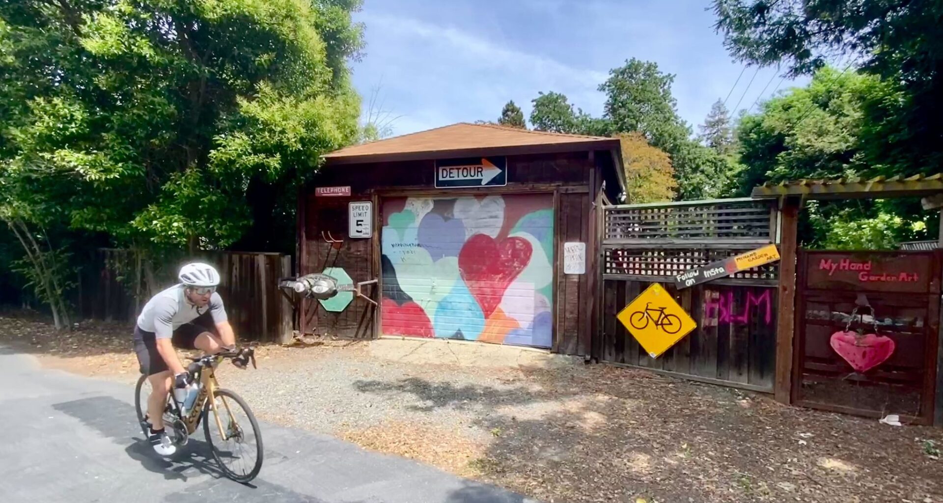
Public art is common along the Iron Horse Regional Trail, which extends for 32 miles on a former railway in the San Ramon Valley.
Peter Hartlaub/The Chronicle
A bicyclist crosses a bridge on the Iron Horse Regional Trail, which follows the route of a former Southern Pacific railway line.
Peter Hartlaub/The Chronicle
Public art is visible in Dublin along the Iron Horse Regional Trail.
Peter Hartlaub/The Chronicle
A whimsical sign along the Iron Horse Regional Trail.
Peter Hartlaub/The Chronicle
A sign promoting downtown Alamo along the trail, which passes through Concord, Pleasant Hill, Walnut Creek, Alamo, San Ramon, Dublin and Pleasanton.
Peter Hartlaub/The Chronicle
Long before E-40 and half the Golden State Warriors bought homes in San Ramon Valley, the region was known for its prunes.
In the first half of the 20th Century, Danville, Alamo and San Ramon were railway towns, existing to transport orchards full of plums, walnuts and pears. The suburbs expanded after World War II, and wealthy Bay Area residents filled the open land. Southern Pacific shut down the rail lines in 1978. Lululemon and Tesla stock soared.
But rail-to-trail advocates saw an opportunity in the miles of abandoned track and spent 40 years deftly squeezing cooperation out of scores of stakeholders including cities, counties, sanitary districts and NIMBY homeowners, who helped fight back a light rail plan for the space.
Article continues below this ad
The glorious result is the Iron Horse Regional Trail, a 32-mile bike/pedestrian path on the old Southern Pacific rail line. Extending in a straight shot from the northern edge of Concord to Pleasanton, it passes through six major parks and five downtowns with transit accessible on either end. Leaving from my home in Alameda, the heavily BART-assisted journey took fewer than five hours round trip.
The trail is well-known to locals, but beyond residents living in the shadows of Mount Diablo, this beginner-friendly bike route is far from common knowledge. Exploring the Bay Area is my full-time job, and last week was the first time I set eyes on it.
San Francisco Chronicle Logo
Make us a Preferred Source to get more of our news when you search.
Add Preferred Source
Iron Horse, which skirts downtown Walnut Creek, Alamo, Danville and San Ramon, gets even better after a quick history lesson.
Mile markers are painted on the pavement along the trail, which converted a former railway track to a multi-use walking and biking route.
Peter Hartlaub/The Chronicle
The railway’s “San Ramon Branch Line” was built in the 1890s, arguably putting several Contra Costa County cities on the map. But as the Bay Area population nearly doubled from 1950 to 2000, the farming communities became increasingly desirable sun-drenched suburbs. When Southern Pacific closed the line, advocates secured a few miles at a time, using the small successes to show that property values weren’t tanking and convince reluctant communities to buy in. The latest 1.6-mile extension, connecting Pleasanton to Dublin, was completed in 2014. The trail is managed by East Bay Regional Park District.
Article continues below this ad
My Iron Horse starting point is North Concord BART, less than a mile from the trail’s northern tip, which I reach in under an hour from Alameda, taking the “Woodstock” water shuttle to Jack London Square, then biking two miles to West Oakland BART.
I’m struck again by North Concord station’s rural views — cows graze outside the platform — and find the Iron Horse trailhead past the Solano Drive-In and tucked behind a Hyundai dealership.
Iron Horse is an as-the-crow-flies path, set up to haul prunes and passengers the shortest possible distances. But my worries that this ride will be monotonous quickly disappear when a propeller-powered Cessna passes directly overhead, close enough that I want to duck. Concord’s tiny Buchanan Field Airport is flush against the route.
A former railroad bridge has been converted for bicyclists along the Iron Horse Regional Trail in Contra Costa County.
Peter Hartlaub/The Chronicle
The next few miles are less memorable. Concord and Pleasant Hill pass behind chain link fences and overgrown weeds; prominent landmarks are a waterslide to the left and Willows shopping mall to the right. There’s trash behind the box stores and tents set up in the aqueduct running parallel to the trail. As I pedal into a headwind, I realize that heading south might have been a tactical blunder.
Article continues below this ad
But beyond the mall at the 5-mile mark I reach an ancient cantilever bridge, now with wooden planks instead of rails, and Iron Horse starts to find its groove. Remnants of a pear orchard jump-start the time travel experience. I see the first of many public art installations, a garage door and fence adorned with hearts, and a “DETOUR” road sign pointing my way.
After crossing a modern bridge built in the 1990s over six-lane Ygnacio Valley Road I lose track of where I am, a welcome feeling of disorientation and discovery that carries through most of the rest of the ride. Familiar downtown Walnut Creek sneaks up on me. I pass on a Nordstrom men’s department side quest and accelerate into the countryside.
A happy face is placed on a tree near Walnut Creek along the Iron Horse Regional Trail.
Peter Hartlaub/The Chronicle
After threading through the massive trusses of Interstate 680 — Iron Horse runs parallel but mostly out of sight of the freeway — I’m in a valley, offering some wind protection. The sun is overhead, but canopies of trees give intermittent shade. I stop looking at the map on my phone, stop taking photos and focus on the moment.
Iron Horse offers a lot of the same joys as San Francisco’s Crosstown Trail, featuring new paths through familiar spaces. I’ve stopped in Alamo and San Ramon to get gas or coffee, but now I’m passing through neighborhoods and by schools, getting a sense of the cadence of life here. Short on landmarks and breathtaking sights, this trail is about appreciating everyday pleasures.
Article continues below this ad
At the midpoint of my 26-mile journey I detour about 100 feet off the trail into the Brass Bear Delicatessen in Alamo, my nomination for the most charming strip mall deli on the planet (the entryway looks like Filoli Gardens), and grab a turkey, avocado and havarti sandwich for later.
I always worry about bathrooms on trips like this, but not today. I see three 7-Elevens during the first third of the trip, and local parks touch the trail on the second half, including Hemme Station Park in Alamo and San Ramon’s Central Park. There may be more public restrooms adjacent to this trail than in all of San Francisco.
High schoolers run near San Ramon on the Iron Horse Regional Trail. The route stretches from Concord to Pleasanton.
Peter Hartlaub/The Chronicle
Between the downtowns, parks and schools along the route are whimsical art pieces both ambitious (a family of wood bears carved on pedestals) and spontaneous (a hubcap-sized happy face on a tree). As I enter the 3 p.m. hour and the last five miles of my ride, I share my path with dozens of school children commuting on e-bikes. I’m surprised when a pack of track athletes from San Ramon’s California High School — go Grizzlies! — pass me in long easy strides.
Iron Horse turned out to be a pioneer. The rails-to-trails movement picked up in the 1980s, with marquee successes including the High Line in New York, and much less heralded ones including Jean Sweeney Open Space Park in Alameda.
Article continues below this ad
Peter Hartlaub takes a photo before a 26-mile ride on the Iron Horse Regional Trail.
Peter Hartlaub/The Chronicle
Meanwhile, the Iron Horse Regional Trail is far from finished. There are plans to span from Suisun Bay on the northern tip to Livermore in the southeast. (Maybe around the time the most slept-on Bay Area downtown gets its own BART station.)
The trail continues six more miles into Pleasanton. But I detour to the Dublin/Pleasanton BART station, eyes darting between my turkey sandwich and the “no food on BART” signs. I’m less exhausted than I thought I’d be, and more fulfilled, wondering for the 1,000th time how many other Bay Area treasures I’ve been missing out on.