
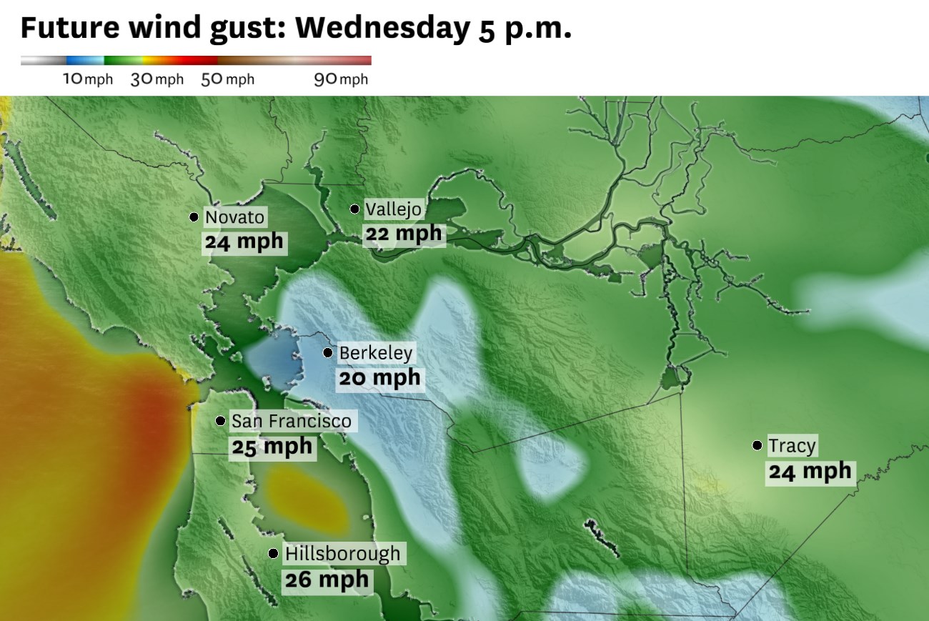
Gusty west winds will develop Wednesday afternoon, with many Bay Area locations seeing gusts around 20 to 30 mph by early evening.
Baron/Lynx
Latest forecast: Strong winds to whip California, increasing fire danger and churning seas
The Bay Area will have one more cool day before a slow warmup into the weekend.
A deep marine layer will keep low clouds wrapped around the coast, bayshore and parts of the inland valleys early in the day Wednesday, while a weak storm passing well to the north reinforces the onshore flow. The result will be a cooler, breezier day across much of the region, especially compared with the warmer inland weather earlier in the week.
Article continues below this ad
But that does not mean the sun won’t come out.
A slight direction change in the onshore flow will help to break up cloud cover in the city and around the bay by Wednesday afternoon. So after a cloudy morning commute, especially around San Francisco and the Peninsula coast, spots of sunshine will start to squeeze through the clouds.
San Francisco Chronicle Logo
Make us a Preferred Source to get more of our news when you search.
Add Preferred Source
By the afternoon, sunshine should break out across most of the Bay Area — the exception being the immediate coast in places like Half Moon Bay and Pacifica, where clouds may hang on longer and keep temperatures in the upper 50s to low 60s.
Despite the sunshine, gusty winds will ensure that a bit of a chill remains in the air. West and northwest winds will increase through the afternoon, with most places seeing gusts around 20 to 30 mph. Stronger gusts are possible along the coast, through the East Bay gaps and over the higher terrain as well.
Article continues below this ad
Highs Wednesday will mostly land in the 60s near the coast and bay, with 70s inland. San Francisco should top out in the mid-60s, Oakland near 70, San Jose in the low 70s, and Concord and Napa in the mid-70s. Interior valleys will be slightly cooler than Tuesday.
Wednesday’s highs will stay mild near the coast and bay, while inland areas climb into the 70s and low 80s before a stronger warmup Thursday.
Baron/Lynx
Warmer temperatures will return Thursday as the storm system to the north moves away and high pressure rebuilds. Inland highs should jump back into the 80s, with parts of the North Bay, East Bay and South Bay warming sharply by Thursday and Friday.
Wednesday breakdown
San Francisco: Morning clouds will be most stubborn on the west side, especially in the Richmond, Sunset and around Ocean Beach. Downtown, SoMa and the Mission should see better clearing by late morning or midday. Highs will range from the upper 50s near the ocean to the mid-60s in warmer eastern neighborhoods. West winds will increase to 10 to 20 mph during the afternoon, with higher gusts near the water. Overnight lows will fall into the lower 50s.
Article continues below this ad
North Bay: Wednesday should start brighter than Tuesday, with a good amount of sunshine in the morning. Highs will reach the low to mid-70s in most valleys, with upper 70s possible around Santa Rosa and Vacaville. Vallejo should stay a bit cooler, generally in the upper 60s to low 70s with the bay breeze. Coastal Marin and Point Reyes will stay cooler, mostly in the upper 50s to low 60s. West winds will gust 20 to 30 mph. Skies will be mostly clear overnight with temperatures falling back into the 40s.
East Bay: Morning clouds may linger from Richmond and Berkeley south toward Oakland and Hayward, but inland areas should turn sunny faster. Highs will reach the upper 60s near the bay, around 70 in Oakland and Fremont, and low to mid-70s in Walnut Creek, Concord, Pleasanton and Livermore. West winds will pick up during the afternoon, with gusts around 20 to 30 mph and stronger gusts possible through the Altamont Pass and other gaps. Overnight lows will settle in the upper 40s to low 50s.
Pacific Coast and Peninsula: The immediate coast will be one of the cooler zones Wednesday. Pacifica, Daly City and Half Moon Bay will start cloudy and may only partially clear, with highs near 60. Farther inland, San Mateo and Redwood City should see afternoon sun and highs in the upper 60s to around 70. Northwest winds will strengthen by afternoon, especially near the coast and exposed ridges. Overnight lows will drop into the upper 40s to low 50s.
South Bay and Santa Cruz: San Jose, Mountain View and Milpitas will start with some cloud cover, then turn sunnier by late morning. Highs will reach the low 70s, with mid-70s around Morgan Hill and Gilroy. Santa Cruz should be milder than the immediate Peninsula coast, with highs in the low 70s after morning clouds clear. Winds will generally run 10 to 20 mph by afternoon, strongest near the hills and coastal gaps. Overnight lows will fall into the upper 40s to low 50s, with patchy fog possible near Santa Cruz.
Article continues below this ad