
Red Flag Warning: Planned, unplanned outages happening across NorCal due to heavy wind, fire risk
RELIES ON MORE SNOWMELT. TIME FOR KCRA 3 WEATHER. NOW LET’S GET A CHECK ON TODAY’S WEATHER IMPACT DAY WITH METEOROLOGIST KELLY CURRAN AND KELLY. IT WAS QUITE BREEZY YESTERDAY. WILL IT BE THE SAME TODAY? IT CERTAINLY WAS. I MEAN, IN FACT, AT SFO THEY CLOCKED A WIND GUST TO 42MPH MODESTO YESTERDAY, CLOCKING WINDS AT GUSTING TO 38MPH. AND THE WINDS TODAY ARE GOING TO BE EVEN STRONGER THAN WHAT WE SAW YESTERDAY. RIGHT NOW IT LOOKS BEAUTIFUL. SO YOU’RE INSIDE LOOKING OUT THE WINDOW SUNSHINE. A LITTLE BIT OF HAZE OUT THERE, BUT IT IS ALREADY PRETTY BREEZY. IT’S 61 DEGREES IN SACRAMENTO BUT WINDS OUT OF THE NORTH NORTHWEST AT 16MPH. AND LIKE I SAID, THEY’RE GOING TO GET STRONGER. SO THIS IS A LOOK AT THE SATELLITE RADAR COMPOSITE. THERE ARE SOME SOME ACTIVE WEATHER HERE UP INTO NORTHERN NEVADA. YOU SEE SOME CLOUDS THAT’S ALL ASSOCIATED WITH THIS LOW PRESSURE CENTER HERE. AND THIS LOW IS ALSO THE CAUSE FOR OUR WINDS. SO WE’RE NOT GOING TO GET ANY RAIN OR SNOW OUT OF THE SYSTEM. WE’RE NOT REALLY GOING TO SEE ANY CLOUDS. WE ARE GOING TO BE DEALING WITH VERY GUSTY WINDS, NOT JUST TODAY, BUT ALSO BREEZES LINGERING INTO TOMORROW BEFORE THE WINDS FINALLY START TO SUBSIDE. THE TEMPERATURES THOUGH, THOSE ARE GOING TO START CLIMBING BEHIND THIS SYSTEM. WE’RE GOING TO SEE HIGHS IN THE MID AND UPPER 90S AS WE HEAD TOWARD WEDNESDAY AND THURSDAY OF THIS WEEK. THEN AS WE HEAD INTO THE HOLIDAY WEEKEND, MEMORIAL DAY WEEKEND, ANOTHER TROUGH OF LOW PRESSURE IS GOING TO BE MOVING ITS WAY IN THIS ONE, HOPEFULLY BRINGING WITH IT SOME COOLER, MORE COMFORTABLE TEMPERATURES FOR THE LONG WEEKEND ALONG WITH SOME LIGHTER WINDS. BUT WE STILL DO HAVE THIS RED FLAG WARNING FOR TODAY. AND YOU CAN SEE THAT ALL THE AREAS SHADED IN RED. THIS DOES INCLUDE YUBA CITY, SACRAMENTO, FAIRFIELD, STOCKTON, AND MODESTO. THIS GOES THROUGH 8:00 MONDAY EVENING. NOW TODAY, THIS IS WHEN WE EXPECT TO SEE THE STRONGEST OF THOSE WINDS OUT OF THE NORTH, GUSTING TO AROUND 45MPH. RELATIVE HUMIDITY IN THE AFTERNOON BETWEEN 7 AND 15%. SO VERY DRY CONDITIONS. THE HIGHEST RISK FOR GRASS FIRES WILL THAT IS GOING TO BE ALONG AND WEST OF I-5. NOW, SOME THINGS TO REMEMBER AS FAR AS THAT WILDFIRE SAFETY. DON’T MOW THE GRASS. DON’T USE WEED WHACKERS TODAY, IF THOSE BLADES HIT A ROCK, THAT CREATES A SPARK AND THEN WE END UP WITH A GRASS FIRE. YOU DON’T WANT TO PARK CARS ON GRASS, ESPECIALLY HOT CARS THAT CAN START FIRES. DON’T DRAG CHAINS IF YOU’RE MAKING. IF YOU’RE HAULING ANYTHING, MAKE SURE THAT YOU HAVE EVERYTHING SET UP SO THAT IT’S NOT GOING TO DRAG ON THE GROUND. NO OUTDOOR BURNING, NO BURN BARRELS, NO LEAF PILES, NOTHING LIKE THAT TODAY. AND MAKE SURE YOU’RE DISPOSING OF CIGARETTE — PROPERLY. IT’S ALSO A GOOD IDEA TO MAKE SURE YOU HAVE THAT DEFENSIBLE SPACE AROUND YOUR HOME. SO RAKE UP ANY LEAVES, GET ANYTHING AWAY FROM YOUR HOUSE THAT COULD START ON FIRE. LET’S TAKE A LOOK AT THE SEVEN DAY FORECAST. SO FOR TODAY IN THE FOOTHILLS, TEMPERATURES WILL BE IN THE MID 70S. BUT NOTICE BY WEDNESDAY AND THURSDAY UPPER 80S AND LOW 90S IN THE SIERRA. TODAY 52 DEGREES. IT IS GOING TO BE A BIT BREEZY OVERNIGHT TONIGHT IN THE SIERRA. TEMPERATURES WARMING UP INTO THE UPPER 70S LATER THIS WEEK AND IN THE VALLEY. BUT TODAY AND TOMORROW ARE IMPACT DAYS BECAUSE OF THIS RED FLAG WARNING AND THE STRONG WINDS THAT WE’RE EXPECTING, THE WINDS WILL KEEP THE TEMPERATURES COOL, BUT IT’S HARD TO GET OUTSIDE AND ENJOY IT WHEN YOU’RE DEALING WITH 45 M
Red Flag Warning: Planned, unplanned outages happening across NorCal due to heavy wind, fire risk

Updated: 5:21 PM PDT May 17, 2026
Heavy winds and the risk of fast moving wildfires have spelled multiple outages across Northern California, both planned and unplanned. A National Weather Service Red Flag Warning is in effect across the region, prompting PG&E to prepare preventative power shutoffs for thousands of customers. KCRA 3’s team of meteorologists is considering Sunday a weather Impact Day and we are monitoring outages across the area. Look below for the latest updates on outages and smaller fires5 p.m.: More than 5,000 PG&E customers are without power in El Dorado Hills. The utility’s outage map said the outages are unplanned and the time of restoration is 11 p.m.4 pm.: 10,471 PG&E customers across San Joaquin County are without power. Only 308 of those customers are part of the utility’s planned power shutoffs.2:30 pm.: The Dawson Fire in Stanislaus County has reached 200 acres burned, according to Cal Fire’s website. The fire is burning near Route 59 and Old La Grange Road. Route 59 is closed in the area. Forward progress has been stopped.1 p.m.: More than 7,000 SMUD customers are without power due to an unplanned, weather-related outage. The original restoration time was 12:20 p.m. 12:15 p.m.: PG&E customers in Yuba City, Live Oak and Olivehurst lost power due to an unplanned outage. The utility said the cause is under investigation and there is no estimated time of restoration. 11:45 a.m.: Nearly 16,000 SMUD customers lost service in Sacramento’s Pocket area and near the Sacramento Executive Airport. SMUD said the outage is weather related. 10:39 a.m.: PG&E executed planned restorative shutoffs in parts of Colusa, Glenn, Tehama, Napa, San Joaquin, Stanislaus, Solano and Yolo counties.See a map below of places that could be impacted by planned PG&E outages on Sunday and Monday.See PG&E’s outage map here.Here are key websites that are important for all Californians during wildfire season:Cal Fire wildfire incidents: Cal Fire tracks its wildfire incidents here. You can sign up to receive text messages for Cal Fire updates on wildfires happening near your ZIP code here.Wildfires on federal land: Federal wildfire incidents are tracked here.Preparing for power outages: Ready.gov explains how to prepare for a power outage and what to do when returning from one here. Here is how to track and report PG&E power outages.Keeping informed when you’ve lost power and cellphone service: How to find a National Weather Service radio station near you.Be prepared for road closures: Download Caltrans’ QuickMap app or check the latest QuickMap road conditions here.
Heavy winds and the risk of fast moving wildfires have spelled multiple outages across Northern California, both planned and unplanned. A National Weather Service Red Flag Warning is in effect across the region, prompting PG&E to prepare preventative power shutoffs for thousands of customers.
KCRA 3’s team of meteorologists is considering Sunday a weather Impact Day and we are monitoring outages across the area.
Look below for the latest updates on outages and smaller fires
5 p.m.: More than 5,000 PG&E customers are without power in El Dorado Hills. The utility’s outage map said the outages are unplanned and the time of restoration is 11 p.m.
4 pm.: 10,471 PG&E customers across San Joaquin County are without power. Only 308 of those customers are part of the utility’s planned power shutoffs.
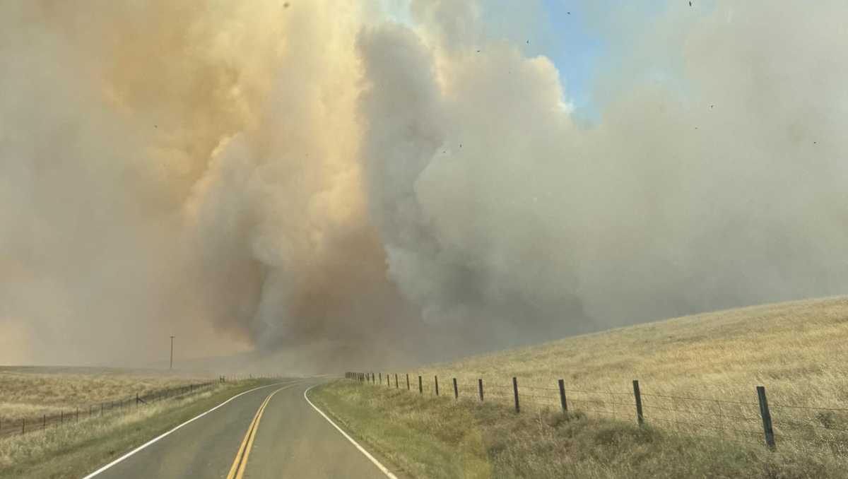
2:30 pm.: The Dawson Fire in Stanislaus County has reached 200 acres burned, according to Cal Fire’s website. The fire is burning near Route 59 and Old La Grange Road. Route 59 is closed in the area. Forward progress has been stopped.
1 p.m.: More than 7,000 SMUD customers are without power due to an unplanned, weather-related outage. The original restoration time was 12:20 p.m.
12:15 p.m.: PG&E customers in Yuba City, Live Oak and Olivehurst lost power due to an unplanned outage. The utility said the cause is under investigation and there is no estimated time of restoration.
11:45 a.m.: Nearly 16,000 SMUD customers lost service in Sacramento’s Pocket area and near the Sacramento Executive Airport. SMUD said the outage is weather related.
10:39 a.m.: PG&E executed planned restorative shutoffs in parts of Colusa, Glenn, Tehama, Napa, San Joaquin, Stanislaus, Solano and Yolo counties.
See a map below of places that could be impacted by planned PG&E outages on Sunday and Monday.
Here are key websites that are important for all Californians during wildfire season: