
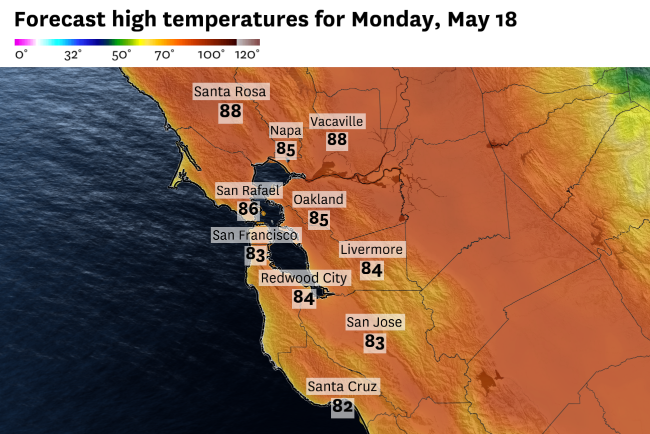
Dry north and northeast winds will weaken the Bay Area’s marine influence Monday, pushing temperatures into the 80s around San Francisco, Oakland, the Peninsula and inland valleys.
Baron/Lynx
The Bay Area’s usual May cooling system will lose some of its grip Monday.
After a sunny but windy and marine-cooled weekend, the pattern will turn drier and much warmer as winds shift from the north and northeast. The change will be most noticeable around the bay, where San Francisco, Oakland and parts of the Peninsula are expected to climb into the 80s.
The same wind shift will also raise fire weather concerns in the hills, where dry air, stronger gusts and curing grasses will overlap.
Article continues below this ad
A low-pressure system moving through Nevada and the interior West will help pull drier air into Northern California, while high pressure starts to build near the coast. For the Bay Area, the important part is the wind direction. Instead of a steady push of cool ocean air from the west, Monday’s flow will come more from the north and northeast, cutting down the marine influence that usually keeps coastal and bayside temperatures in check.
San Francisco is forecast to reach the low 80s Monday, with the warmest readings probably downtown and in SoMa, the Mission and other eastern neighborhoods. Oakland, Berkeley and parts of the Peninsula should also make a run at 80 degrees.
San Francisco Chronicle Logo
Make us a Preferred Source to get more of our news when you search.
Add Preferred Source
An 80-degree reading Monday would be San Francisco’s warmest day in more than a month. The city last hit 80 degrees on April 4 and 5, capping an unusually warm early spring stretch. March alone brought seven days at or above 80 degrees, including San Francisco’s first recorded 90-degree reading during the month.
Monday’s warmup will not be a one-day pattern, but it also won’t stay as clean as the initial offshore wind shift.
Article continues below this ad
The warmest and driest part of the setup arrives Monday into Tuesday, as north and northeast winds weaken the marine influence around the bay. After that, high pressure is expected to rebuild over the Pacific Northwest, while a broader trough develops over Southern California. That leaves the Bay Area in between, close enough to high pressure for inland warmth but close enough to the coast for day-to-day microclimate vagaries to matter.
That is where spring in the Bay Area can get tricky. The pattern will not be as extreme as the weekend, when winds were gusty at times and became stronger by Sunday night. But it will feature a sharp temperature split.
Interior parts of the North Bay and East Bay, including Santa Rosa, Napa, Concord and Dublin, are likely to see several days near or above 90 degrees from Wednesday onward. San Jose and parts of the South Bay should also stay warm, with highs generally in the upper 80s. Even without much cloud cover, shallow ocean-cooled air can hold temperatures down near the coast and around the bay.
That could set up a stiff temperature gradient by midweek, with San Francisco and the Pacific Coast falling back toward the low 70s under sunny skies while inland valleys push into the upper 80s and low 90s. Oakland and the bayside East Bay will sit closer to the edge of that divide, probably warmer than the coast but more vulnerable to small shifts in wind direction and marine air.
Article continues below this ad
Dry winds and warm temperatures raise fire weather concerns
Red flag warnings are in effect through 8 p.m. Monday for the entire Central Valley from Redding to Bakersfield, where gusty winds, low humidity and hot temperatures are expected.
The warnings do not include the Bay Area, but the same dry wind pattern will raise more focused fire weather concerns in the region’s hills and grasslands. The greatest threat will be north and east of the Bay Area, especially across the Sacramento Valley, nearby foothills and adjacent ridges, where gusty north and northeast winds will overlap with very low humidity and increasingly dry grasses.
Locally, the concern will be highest in the North Bay interior mountains, East Bay hills, eastern Santa Clara hills and Santa Cruz Mountains. Those are the areas where dry air, stronger gusts and grassier fuels are most likely to overlap.
Article continues below this ad
Red flag warnings, shown in pink, are in effect through 8 p.m. Monday for large parts of inland California, including much of the Central Valley. The Bay Area is not included in the warnings, but dry winds will raise more focused fire weather concerns in the hills and grasslands.
Baron/Lynx
North Ops fire weather guidance highlights cured and curing grasses as the main fire-spread concern through Monday, especially across the Sacramento Valley foothills and the Diablo and Santa Cruz mountains. Brush and timber fuels are still less receptive because of spring green-up, which should limit the broader risk compared with peak fire season.
Small fires could still spread quickly in grassier areas, especially into Monday morning, when north and northeast winds are expected to be strongest over exposed ridges and higher terrain. Winds should ease later Monday, but very dry air will remain in place.
Monday breakdown
San Francisco: Monday will be sunny, dry and unusually warm for the city. Highs will reach the low 80s downtown and in SoMa, the Mission and Potrero Hill, with mostly 70s closer to the Outer Sunset, Richmond District and Ocean Beach. North to northeast winds may be noticeable early, but the strongest winds will stay over the hills and higher terrain. A lighter onshore breeze may return later in the day. Overnight lows will fall into the low to mid-50s.
Article continues below this ad
North Bay: Sunny, warm and dry conditions are expected across the North Bay. Santa Rosa, Petaluma, Novato, San Rafael and Napa will climb into the 80s, with Vallejo slightly cooler near the water and Vacaville probably one of the warmer spots, reaching the upper 80s. Gusty north to northeast winds will be most noticeable Monday morning in the interior hills and exposed ridges, where fire weather concerns will be elevated. Overnight lows will range from the upper 40s in sheltered valleys to the upper 50s in windier hills.
East Bay: Monday will be sunny and warmer across the East Bay. Oakland, Berkeley and Alameda should rise into the upper 70s to low 80s, while Concord, Walnut Creek, Pleasanton and Livermore reach the mid- to upper 80s. Winds will be strongest into Monday morning in the hills, near gaps and passes and along exposed ridges, where dry grasses and low humidity will raise fire weather concerns. Winds should ease later Monday. Overnight lows will be in the low to mid-50s.
Pacific Coast and Peninsula: The immediate coast will stay cooler than the rest of the region, but Monday should still be warmer and sunnier than a typical marine layer day. Half Moon Bay should reach the low 70s, while Pacifica and Daly City could climb into the mid- to upper 70s if the offshore influence holds. San Mateo, Redwood City and other bayside Peninsula communities will climb into the upper 70s to low 80s. A lighter onshore breeze may return near the coast later in the day. Overnight lows will settle in the low 50s.
South Bay and Santa Cruz: Monday will be sunny, dry and warm. San Jose should reach the low 80s, while Mountain View, Milpitas and Cupertino range from the upper 70s to low 80s. Los Gatos, Morgan Hill and Gilroy will climb into the low to mid-80s, with Gilroy probably one of the warmer spots. Santa Cruz should be warmer than usual for the coast, probably reaching the upper 70s to low 80s if the offshore influence holds through the afternoon. Fire weather concerns will be highest in the Santa Cruz Mountains and eastern Santa Clara hills, where winds will be stronger and humidity lower. Overnight lows will fall into the low to mid-50s.