
Northern California forecast: A Boo-tiful Halloween and weekend
The day and evening will be quite the treat for all Halloween festivities
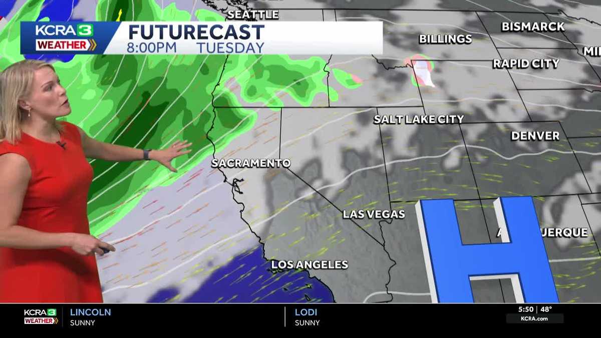
FOR SURE. INTERESTING. SUPER INTERESTING. YEAH, YEAH. TAMARA BERG LET’S TALK ABOUT SOMETHING THAT DOESN’T STINK. IT’S THE WEATHER. YEAH, THE WEATHER LOOKS FANTASTIC. NOTHING TO BE SPOOKED ABOUT FOR THIS HALLOWEEN FORECAST, ESPECIALLY TONIGHT, IF YOU HAVE LITTLE ONES THAT ARE GOING TO BE GOING OUT AND TRICK OR TREATING THIS MORNING, THEY’RE PROBABLY GOING TO WANT TO LAYER AS YOU GET THEM OUT THE DOOR TO THE CLASSROOMS. 49 SACRAMENTO 49 HERE IN STOCKTON. AND THAT’S WHAT IT LOOKS LIKE RIGHT NOW FROM THE SOUTH ARENA. SKY CAMERA A LITTLE BIT OF HAZE SETTING UP SHOP, BUT NOTICE THAT AROUND THE STOCKTON AREA WE’RE NOT SEEING ANY BIG SIGNIFICANT DROPS IN VISIBILITY. MODESTO WAKING UP TO 54 LAKE TAHOE AT 30 DEGREES. LET ME SHOW YOU WHERE SOME OF THE FOG HAS SET UP, BECAUSE IF YOU’RE HEADING OUT ON THE ROADWAYS NOW, OF COURSE, KEEP IN MIND NOW UNTIL ABOUT AN HOUR FROM NOW, IT’S GOING TO BE DARK OUT THERE UNTIL THE SUN, OF COURSE, COMES UP. IT’S GOT SOME HAZY SKIES, BUT SACRAMENTO VISIBILITY LOOKS OKAY. YOU CAN SEE SOME OF THAT FOG IS DEVELOPED JUST EAST OF SACRAMENTO, WORKING ALONG HIGHWAY 50, ESPECIALLY SOME OF THOSE LOW LYING FIELDS RIGHT INTO RANCHO CORDOVA. NOW FOR I-5, 99 COMMUTERS BETWEEN STOCKTON AND MODESTO. JUST A LITTLE BIT OF HAZE AS DEVELOPED. NOTHING THAT’S REALLY OBSTRUCTING YOUR VISIBILITY TODAY, THE FINAL DAY OF OCTOBER. IT’S GOING TO COME IN PLENTY WARM ABOVE THAT NORMAL, WHICH IS TYPICALLY 72 FORECAST HIGH. TODAY WE’RE GOING TO DO 80 DEGREES. SOMETHING ELSE TO REMEMBER AS WE GET INTO THIS WEEKEND AND BEYOND. OF COURSE TIME CHANGE. SO SUNSET TONIGHT FOR TRICK OR TREATERS. THAT’S AT 6:06 P.M. THEN ONCE WE GET INTO SUNDAY THE SUN IS GOING TO GO DOWN AT 504 IN THE EVENING. AND BEYOND THAT, SOME OF THE THE EARLIEST SUNSET WE WILL SEE IS DECEMBER 2ND, WHEN THE SUN GOES DOWN AT 444. YES, WE ARE GOING TO BE SEEING AGAIN SOME SHORTENED DAYLIGHT PERIOD AS WE GO FORWARD, BUT THE WEEKEND LOOKS GREAT FOR GETTING OUTDOORS. HIGH PRESSURE, RIDGE IN CONTROL, AND WE’LL NOTICE THAT WE’LL JUST SEE A FEW HIGH CLOUDS HERE AND THERE OVER THE WEEKEND. WE GET INTO MONDAY. MORE CLOUD COVER STARTS TO EXTEND, THE ONSHORE BREEZE STARTS TO PICK UP. YOU START TO NOTICE THOSE SUBTLE CHANGES ON MONDAY. BUT MONDAY IS GOING TO BE A DRY DAY. LOOKING AHEAD TO TUESDAY, MOST OF THE MOISTURE JUST KIND OF LOOMS HERE TO OUR NORTH AND WE ARE GOING TO TAP INTO SOME ATMOSPHERIC RIVER MOISTURE SO THAT RIVER OF WATER, ALONG WITH THE SYSTEM PUSHING IT THROUGH, IS GOING TO EVENTUALLY HIT OUR AREA BY WEDNESDAY. AND THIS COULD MEAN HALF AN INCH, MAYBE UP TO AN INCH OF RAINFALL POSSIBLE FOR THE VALLEY. WHAT THAT MEANS FOR YOU IN THE FOOTHILLS. WE DO HAVE AN IMPACT DAY FOR WEDNESDAY. YOUR WEEKEND LOOKS GREAT WITH UPPER 60S TO LOW 70S AND FOR THE SIERRA PLAN FOR THOSE HIGHS IN THE 60S. EVEN SOME 70S THIS WEEKEND BEFORE THE BIG CHANGE ARRIVES ON WEDNESDAY. OF COURSE. AGAIN, DON’T FORGET TO SET YOUR CLOCK BACK AN HOUR SATURDAY NIGHT BEFORE YOU HEAD TO BED. WE HANG ON TO THE 80S, GUYS. WOW. FOR THE START OF NOVEMBER. THAT’S PRETTY WARM. AND THEN EVENTUALLY WE BREAK OUT IN THO
Northern California forecast: A Boo-tiful Halloween and weekend
The day and evening will be quite the treat for all Halloween festivities

Updated: 7:10 AM PDT Oct 31, 2025
The day and evening will be quite the treat for all the Halloween festivities in Northern California.Wind will be light, and some high clouds are expected through the day. Valley highs will climb to the low 80s. Highs in the Foothills will be in the mid-70s, with peak temperatures in the Sierra near the upper 60s.For trick-or-treat, evening temperatures in the valley will start in the low 70s and drop to mid-60s.The weather will be similar for the weekend: valley highs in the upper 70s to low 80s under a few clouds, with light winds.Our stretch of quiet weather lasts into the start of next week, but the next chance of rain arrives Wednesday as a trough swings into the region. This may guide atmospheric river moisture into Northern California, producing significant rainfall. Wednesday is an Impact Day for wet and cooler weather.REAL-TIME TRAFFIC MAPClick here to see our interactive traffic map.TRACK INTERACTIVE, DOPPLER RADARClick here to see our interactive radar.DOWNLOAD OUR APP FOR THE LATESTHere is where you can download our app.Follow our KCRA weather team on social mediaMeteorologist Tamara Berg on Facebook and X.Meteorologist Dirk Verdoorn on FacebookMeteorologist/Climate Reporter Heather Waldman on Facebook and X.Meteorologist Kelly Curran on X.Meteorologist Ophelia Young on Facebook and X.Watch our forecasts on TV or onlineHere’s where to find our latest video forecast. You can also watch a livestream of our latest newscast here. The banner on our website turns red when we’re live.We’re also streaming on the Very Local app for Roku, Apple TV or Amazon Fire TV.See more coverage of top California stories here | Download our app | Subscribe to our morning newsletter | Find us on YouTube here and subscribe to our channel
SACRAMENTO, Calif. —
The day and evening will be quite the treat for all the Halloween festivities in Northern California.
Wind will be light, and some high clouds are expected through the day. Valley highs will climb to the low 80s. Highs in the Foothills will be in the mid-70s, with peak temperatures in the Sierra near the upper 60s.
For trick-or-treat, evening temperatures in the valley will start in the low 70s and drop to mid-60s.
The weather will be similar for the weekend: valley highs in the upper 70s to low 80s under a few clouds, with light winds.
Our stretch of quiet weather lasts into the start of next week, but the next chance of rain arrives Wednesday as a trough swings into the region. This may guide atmospheric river moisture into Northern California, producing significant rainfall. Wednesday is an Impact Day for wet and cooler weather.
REAL-TIME TRAFFIC MAP
Click here to see our interactive traffic map.
TRACK INTERACTIVE, DOPPLER RADAR
Click here to see our interactive radar.
DOWNLOAD OUR APP FOR THE LATEST
Here is where you can download our app.
Follow our KCRA weather team on social media
Meteorologist Tamara Berg on Facebook and X.Meteorologist Dirk Verdoorn on FacebookMeteorologist/Climate Reporter Heather Waldman on Facebook and X.Meteorologist Kelly Curran on X.Meteorologist Ophelia Young on Facebook and X.
Watch our forecasts on TV or online
Here’s where to find our latest video forecast. You can also watch a livestream of our latest newscast here. The banner on our website turns red when we’re live.
We’re also streaming on the Very Local app for Roku, Apple TV or Amazon Fire TV.
See more coverage of top California stories here | Download our app | Subscribe to our morning newsletter | Find us on YouTube here and subscribe to our channel