

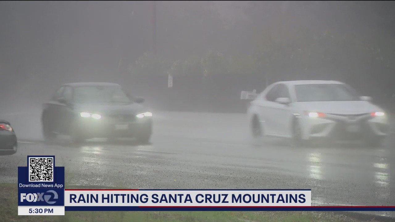
South Bay motorists were urged to show caution on Monday as a strong early season storm pounded the region with rain.
OAKLAND, Calif. – Rain returned to the Bay Area on Monday, with showers scattered in the North Bay and more rainfall expected across the wider Bay Area later in the day.
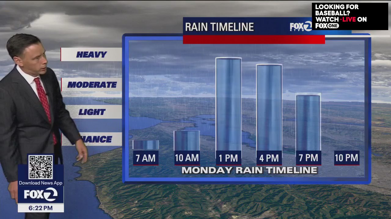
The Monday morning commute was mostly dry, but weather conditions are expected to deteriorate later, bringing heavier rain into the afternoon and evening.
A strong low pressure system offshore near Oregon and Washington is diving southward, aided by a dip in the polar jet stream, bringing the wet weather to California, according to KTVU Meteorologist Roberta Gonzalez.
The North Bay, including Sonoma and Napa counties, were the first areas to see rain on Monday. Later in the day, the East Bay, Peninsula and the South Bay will see cloudiness, along with heavier rain.
Live Updates 7:41 p.m.
Flood advisory for southern Alameda and western Santa Clara counties now extended through 10 p.m.
6:12 p.m.
A flood advisory was issued for southern San Mateo and northwest Santa Clara Counties, including Palo Alto and Redwood City, and is in effect until 9 p.m. Minor road and low-lying area flooding is expected.
5:50 p.m.
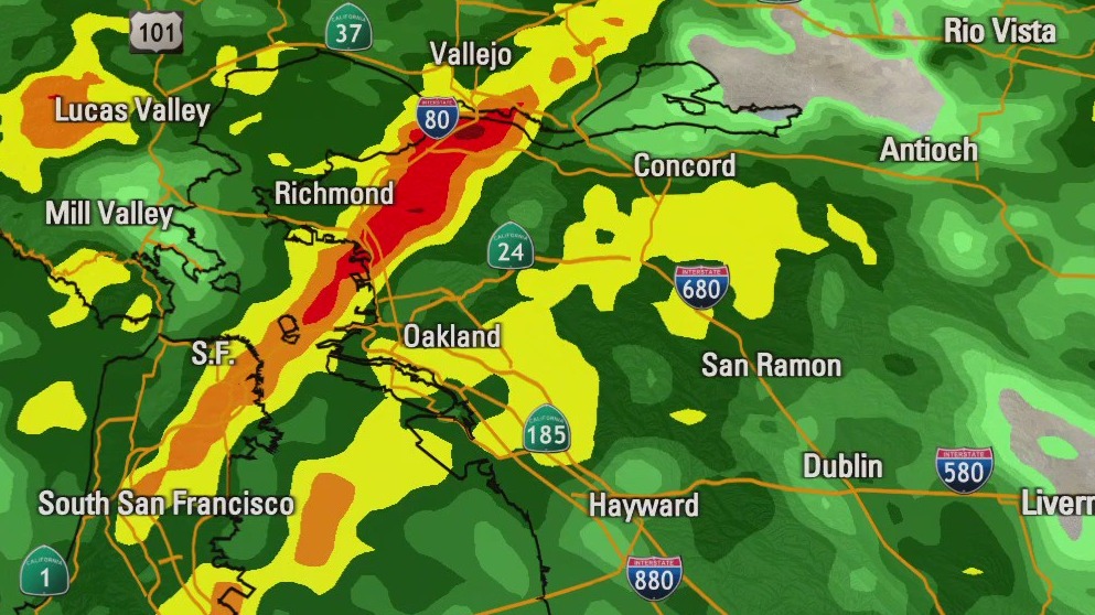
The California Highway Patrol Oakland division issued a traffic alert for flooding along northbound Interstate 880 to eastbound Interstate 980.
5 p.m.
A flood warning for Napa County has expired.
4:27 p.m.
A flood advisory was issued for western Santa Cruz County, including the cities of Boulder Creek and Ben Lomond until 7:15 p.m.
3:40 p.m.
A flood advisory has been issued for western Alameda County and central Contra Costa County until 7:30 p.m. In San Francisco and northern San Mateo County, a flood advisory including the cities of Oakland, Berkeley, Richmond, San Bruno, Pacifica and Millbrae is in effect until 6:45 p.m.
3:30 p.m.
Napa County’s flash flood warning has been extended to 5 p.m., according to the National Weather Service.
In Marin and Sonoma counties, a flood advisory is in effect until 6:30 p.m.
3 p.m.
A flash flood warning is in effect in Napa County in the area of the Pickett Fire burn scar, according to the National Weather Service.
The warning is in effect until 3:30 p.m.
“Excessive rainfall will result in debris flow moving through the Simmons Canyon and areas near and between Pickett Road to Silverado Trail. Move away from the burned areas,” the NWS advised.
The evening commute will likely be impacted, Gonzalez said.
“Plan on a very messy evening commute with the possibility of a flash flood, advisory, or watch issued for parts of the Bay Area,” she said.
 First storm of the season rolls into Bay Area
Portions of the North Bay saw scattered showers Monday, with the greater Bay Area getting its share later in the day and during the evening commute. The wet weather marked the first storm of the season for the region.
How much rain will the Bay Area get?
Thunderstorm risk remains modest early in the day, but as instability increases, isolated lightning can’t be ruled out, particularly along California’s central coast.
Rain will likely persist through the evening, bringing the strongest part of the storm Monday night.
The Santa Cruz mountains could see 2 to 3-inches of rain, while other parts of the Bay Area will see a half-inch to 1-inch of rain.
Big changes in the Bay Area weather pattern! A potent system will drift down the coast Monday, bringing rain, thunderstorms, and gusty winds. Rain is expected to pick up mid-morning Monday. Rainfall, possibly, heavy at times, will move over the entire Bay Area by noon, Heads up for the Sierra! A Winter Storm Warning will be in effect for the West Slopes of the Sierra. Showers and thunderstorm chances remain in the Tuesday forecast.
Lake Tahoe snow
Near Lake Tahoe, a winter weather advisory is in effect from 11 a.m. Monday to 11 a.m. on Wednesday.
The storm will bring periods of rain at lower elevations and snow at higher elevations from Monday into Tuesday night.
Snow levels are expected to hover around 6,500 to 7,000 feet initially.
By tonight, the Sierra can expect 1 to 4 inches of snow above 7,000 feet, plus another 2 to 6-inches on Tuesday.
Travel across the Sierra may become difficult to impossible during peak snowfall and strong winds.
Track live weather conditions with KTVU’s interactive radar.
The Source: KTVU Meteorologist Roberta Gonzalez