
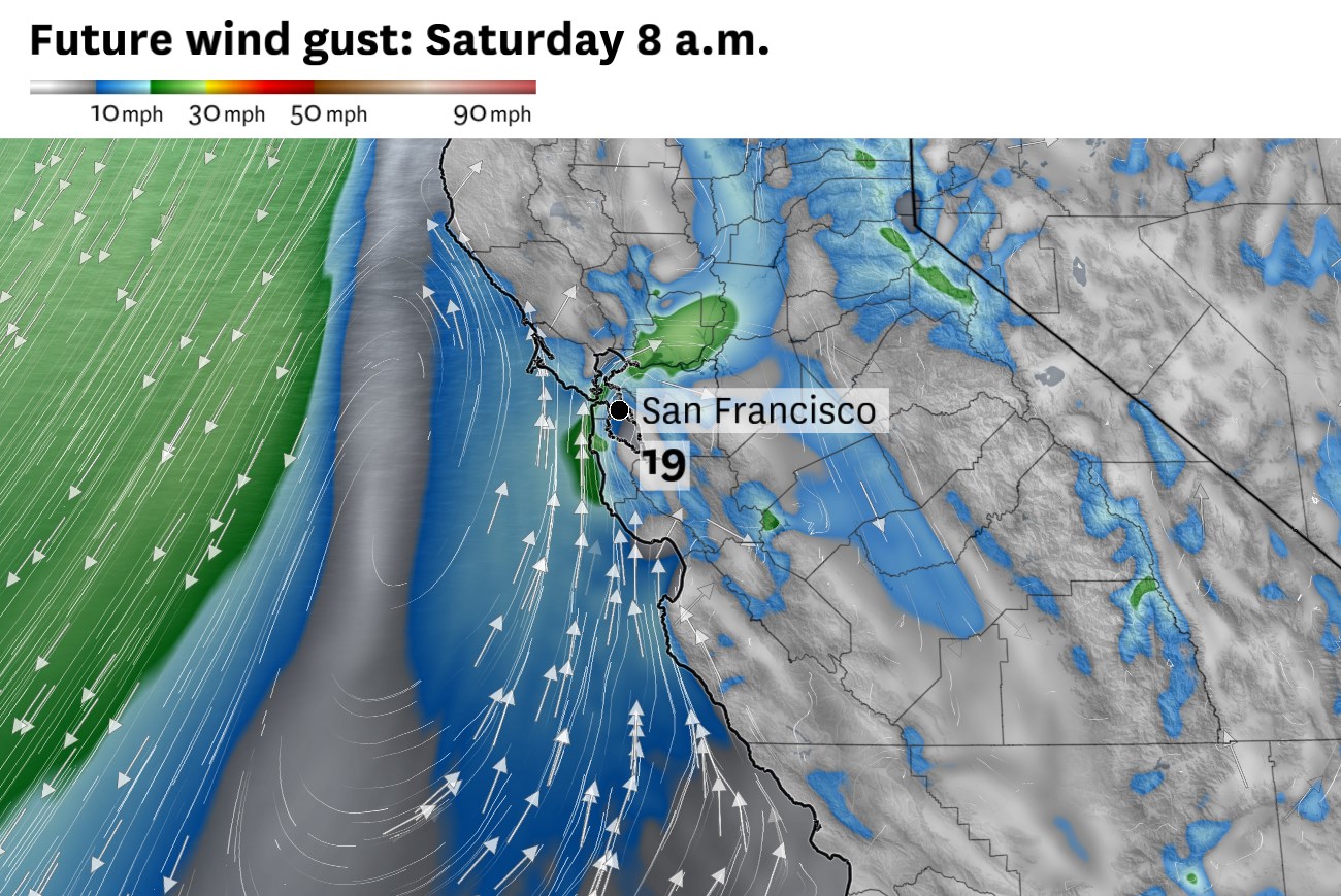
Southerly winds along the coast and northerly winds farther offshore are expected to spin up a coastal eddy west of San Francisco on Saturday morning. These patterns can contribute to cool, cloudy mornings in the North Bay and warmer, sunnier weather in the South Bay.
Baron/Lynx
People staying in the Bay Area for Memorial Day weekend will experience seasonably mild weather along the coast and a gradual inland cooldown.
Low stratus clouds along the coast — otherwise known as fog — formed in earnest Wednesday night along nearly the entire California coast. Bay Area beaches remained overcast Thursday while places just a few miles inland were completely clear.
Article continues below this ad
By Friday morning, fog is expected to push San Francisco and potentially as far east as Oakland and Berkeley. The expanding marine layer will cool the region, ending the threat of 90-degree temperatures inland. Vacaville, Livermore and San Jose are expected to reach the mid- to upper 80s. Coastal areas will remain in the upper 50s to 60s, with 70s along the bay shoreline for the most part.
A counterclockwise-swirling region of winds and clouds, known as a coastal eddy, is expected to form Saturday morning and enhance fog in some areas while keeping others clear.
San Francisco Chronicle Logo
Make us a Preferred Source to get more of our news when you search.
Add Preferred Source
Eddies occasionally form along the coast during spring and summer, often between Point Reyes and San Francisco. They can cause clear skies along the Highway 101 corridor from downtown San Francisco to Redwood City, but enhanced cloud cover over Monterey Bay and San Pablo Bay. Clouds should retreat to the coast by midday.
Weather models predict foggy skies over San Pablo Bay, but mostly clear skies over San Francisco on Saturday morning. An eddy is expected to spin up along the coast and contribute to unusual fog and wind patterns over the region.
Baron/Lynx
The exact position of coastal eddies is tricky to predict. If it forms far north or far south, a different fog pattern will arise.
Article continues below this ad
Another eddy is possible Sunday morning. Southwest winds tend to cool off Wine Country, particularly in Napa Valley. That means highs will be close to 70 degrees at BottleRock, about 5 to 10 degrees lower than what is typical in late May.
Westerly winds are expected to return Monday, ending the possibility of eddies but pushing cooler marine air across the entire Bay Area. Memorial Day will probably be the coolest day of the holiday weekend, with highs slightly below seasonal norms.
Boaters and barbecuers beware: Gusts up to 25 mph in the afternoon could affect those traditional Memorial Day activities.
Holiday weekend breakdown
San Francisco: Temperatures will be relatively consistent throughout the holiday weekend in the city. Highs should reach the mid-60s downtown and other neighborhoods east of Twin Peaks. The Mission could reach the upper 60s Sunday during Carnaval. The Richmond and Sunset districts will be cooler, in the low 60s, but a few degrees cooler — in the upper 50s — within a few blocks of Ocean Beach. Overnight lows will be in the low to mid-50s.
Article continues below this ad
Morning fog and afternoon sunshine is expected to be the general pattern, though swirling winds off the coast may briefly pull clouds away from the entire city, even the beaches, some mornings. Monday is expected to be the cloudiest and coolest day as westerly winds increase, gusting up to 25 mph.
North Bay: A gradual cooldown is expected through the weekend. Friday will be the last of the 80s in Santa Rosa, Healdsburg, Calistoga, Fairfield and Vacaville, as a persistent bay breeze Saturday and Sunday should yield a sharp drop in temperatures. Those days, highs will probably only reach the upper 60s to low 70s in San Rafael, Petaluma, Sonoma, American Canyon and Vallejo, and mid- to upper 70s elsewhere. Monday may be slightly warmer in the early afternoon, but a strong push of westerly winds is expected to be accompanied by some clouds, cooling off the region.
Low clouds are expected to push up San Pablo Bay toward Sonoma and Napa valleys, particularly Saturday and Sunday mornings. Clouds should retreat by late morning but the south-southwest winds will remain, gusting up to 25 mph. Afternoon and evening sunshine will give way to increasing clouds each night. Overnight lows will be in the upper 40s to mid-50s.
East Bay: Near to above-normal temperatures Friday will give way to gradual cooling through the weekend, eventually to below-normal across the entire East Bay for Memorial Day.
On Friday, highs will be in the mid- to upper 60s in Richmond, Berkeley, Alameda and Oakland and increase from the low 70s to near 80 along the Interstate 880 corridor from San Leandro to Fremont. In the interior valleys, highs are expected to range from the low 80s in Lamorinda and Walnut Creek to the mid-80s in the Tri-Valley and upper 80s in Antioch and Brentwood. Temperatures will drop a few degrees Saturday and Sunday, before a more typical split Memorial Day of 60s west of Caldecott Tunnel and 70s to the east. Overnight lows will be in the low to mid-50s, with the greatest chance of morning clouds near San Pablo Bay.
Article continues below this ad
Pacific Coast and Peninsula: The contrast between the beaches and bayshore is expected to be even more pronounced than usual over the holiday weekend. South-southwest winds tend to keep skies mainly clear along the Highway 101 corridor while the coast is blanketed in fog. That’ll unfold this weekend, with highs in the upper 50s to mid-60s at the coast and upper 60s to low 70s near the airport and mid- to upper 70s in San Mateo and Redwood City.
Monday will feature a better chance of fog spilling over the coastal hills into more densely populated areas. Temperatures will also drop by about 5 degrees that day along the Highway 101 corridor, with westerly gusts up to 25 mph in the afternoon. Overnight lows will be in the upper 40s to mid-50s through the weekend.
South Bay and Santa Cruz: San Jose will be one of the warmest places in the Bay Area this weekend as south-southwest winds place the Santa Clara Valley in a favorable position for clear skies and sinking, warming air off the Santa Cruz Mountains. Highs will be in the upper 70s to mid-80s Friday before slowly dropping to the upper 60s to mid-70s by Monday. Lows will be in the low to mid-50s.
Southerly winds tend to keep Santa Cruz cooler. Beach weather will probably be foggy, with high temperatures in the 60s. Sunshine has a better chance of returning Memorial Day. The Santa Cruz Mountains will remain in the upper 70s to low 80s Friday before cooling to the upper 60s to mid-70s Saturday through Monday. Fog may creep as far inland as Scotts Valley in the mornings. Lows will be in the upper 40s to low 50s.
Article continues below this ad