
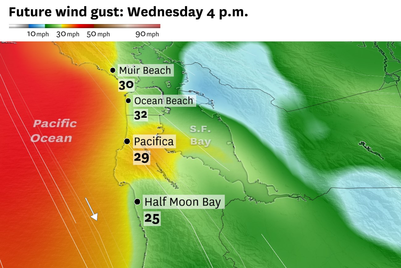
Breezy winds are forecast along the Pacific Coast on Wednesday afternoon. Gusts of 25 to 35 mph are expected from Muir Beach to Half Moon Bay, with stronger winds near San Francisco International Airport.
Baron/Lynx
Less fog and more sunshine will yield a warmer day across the Bay Area on Wednesday.
A weak system brushing the Pacific Northwest won’t bring wet weather to California, but it’ll cause winds to increase along the coast. Those strengthening winds are expected to disturb the stratus deck — the layer of low clouds and fog along the coast — by mixing warmer, drier air into the lower levels of the atmosphere, clearing out the moist, ocean-chilled air.
San Francisco should see more sunshine as a result. Morning fog, if any, will quickly clear. High temperatures should reach the low 70s in downtown San Francisco and mid-70s across the bay in Oakland.
Article continues below this ad
Strong north-northwesterly winds tend to favor Sonoma, Napa, Solano and Contra Costa County for hot weather. Those areas should reach the upper 80s to mid-90s, including Santa Rosa, Napa and Walnut Creek.
The northern portion of Wine Country is forecast to be the hottest part of the Bay Area on Wednesday, with highs in the upper 80s to low 90s.
Baron/Lynx
The only exception to the warming trend is expected to be in the South Bay, where strong northwest winds pushing down the Highway 101 corridor will take an edge off temperatures relative to the North Bay. Still, highs will be about 5 degrees above normal, in the upper 70s to low 80s.
San Francisco Chronicle Logo
Make us a Preferred Source to get more of our news when you search.
Add Preferred Source
Afternoon winds will be stronger than a typical sea breeze. Gusts of 20 to 30 mph are expected across the region, including the Embarcadero in San Francisco and Jack London Square in Oakland. Pacific beaches will gust up to 35 mph, with occasional gusts up to 45 mph at San Francisco International Airport.
Article continues below this ad
The National Weather Service has issued a gale warning from Pigeon Point to Point Arena, which goes into effect at 9 a.m. and continues until Thursday.
It’ll remain breezy Thursday afternoon, though not nearly as strong as Wednesday. Above normal temperatures are expected to continue through Friday before a significant cooldown over the weekend.
Wednesday breakdown
San Francisco: Morning fog coverage is less certain than recent days, but there will probably be at least some areas obscured by clouds until 10 a.m. Sunshine is likely in all neighborhoods from late morning through the early evening. Highs will be in the low to mid-60s in West Portal, Lake Merced, the Presidio and the Richmond, Sunset and Marina districts. Upper 60s to low 70s are expected elsewhere. Gusts of 15 to 25 mph are expected in the afternoon, up to 30 mph near the water and in the hills. Lows will be in the mid-50s with areas of fog.
Article continues below this ad
North Bay: Temperatures will noticeably spike across Wine Country. Morning fog, if any, will clear quickly. Highs should reach the upper 80s across most of the region, with low 90s in northern portions of Alexander, Sonoma and Napa valleys. The Highway 101 corridor from Petaluma to Mill Valley will be in the low to mid-80s. Vallejo is also expected to be in the mid-80s. Coastal areas will remain in the 60s, with gusts up to 50 mph at Point Reyes. Gusts will be in the 20 to 35 mph range elsewhere. Overnight lows will be in the low to mid-50s under mainly clear skies.
East Bay: Clear skies are expected to prevail across the entire East Bay by 9 a.m. The more rapid clearing than Tuesday, and a slight shift in wind direction, will yield warmer weather. Highs will be in the upper 70s to low 80s in Richmond, Berkeley and Oakland and the mid- to upper 70s in Alameda, San Leandro, Hayward and Fremont. Cities east of the Caldecott Tunnel will reach the mid- to upper 80s, with Antioch and Brentwood having the best chance of reaching 90 degrees. Afternoon and evening gusts up to 25 mph are expected, with even stronger breezes near the delta and over Altamont Pass. Overnight lows will be in the 50s with patchy fog possible along the bay shoreline.
Pacific Coast and Peninsula: After remaining overcast nearly all day Tuesday, the Pacific Coast is likely to see some clearing. Patchy fog is possible in the morning but a developing gale will whip away the clouds midday for sunny skies. Patchy low fog may return around sunset, mainly over the coastal hills.
Highs will be in the low to mid-60s in Daly City, Pacifica and Half Moon Bay, the mid-60s to low 70s in South San Francisco, San Bruno, Burlingame and Hillsborough and the low to mid-70s in San Carlos, San Mateo and Redwood City. Gusts of 25 to 35 mph are expected everywhere, with occasional gusts up to 45 mph in the vicinity of SFO. Wind will relax overnight, with lows in the mid-50s under partly cloudy skies.
Article continues below this ad
South Bay and Santa Cruz: Patchy fog in the morning is expected to quickly clear for abundant sunshine the rest of the day. Santa Cruz may be one of the warmest cities in the region, reaching the mid-80s as a result of strong north-northwest winds. Scotts Valley, Los Gatos, Morgan Hill and Gilroy may get similarly warm, but San Jose, Milpitas and Sunnyvale will probably remain in the upper 70s to low 80s. Gusts up to 30 mph are likely in the afternoon. Overnight lows will be in the 50s with increasing clouds.