
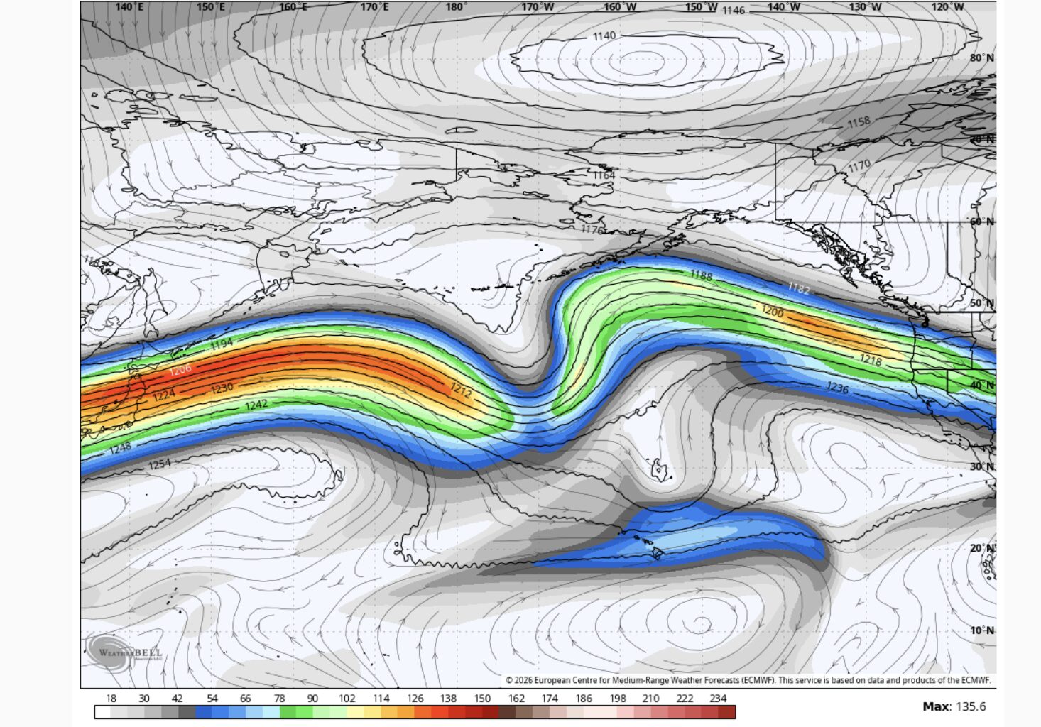
Forecast jet stream winds for next week. The colors show wind speed, with green, yellow and orange indicating the strongest winds. Notice the nearly uninterrupted ribbon of fast-moving air stretching from East Asia to North America, an unusually extended Pacific jet stream for early June.
WxBell
The Bay Area’s Thursday forecast looks fairly quiet, but the atmosphere over the Pacific is not.
After a windy Wednesday, gusts should ease Thursday across much of the Bay Area. And the sun should pop out earlier. Temperatures will be very similar to Wednesday, perhaps a bit warmer in spots. Highs will range from the upper 50s and 60s near the coast to the 70s around the bay, with 80s possible in parts of the North Bay, East Bay and South Bay valleys.
Article continues below this ad
Meanwhile, over the Pacific Ocean, an interesting pattern is taking shape. The jet stream, a narrow band of powerful west-to-east winds about 30,000 to 40,000 feet above the ground, is unusually long right now. By early next week, it may stretch more than 6,000 miles from near Korea to the West Coast.
That does not guarantee rain or storms in California. In winter, this type of Pacific jet extension would often raise the odds of storm activity along the West Coast. In June, the atmosphere lacks the same sharp contrast between cold Arctic air and warm subtropical air, so the result is usually less dramatic.
If anything, an extended Pacific jet can make the pattern less stagnant and more difficult to pin down. Instead of one weather regime holding for several days, California may see quicker two- to three-day shifts between windy cooldowns, passing troughs and sunny warmups. That also means forecast details may change more often than usual.
Blue shades represent a trough, while red and orange shades represent a ridge. Forecast models place California between these larger-scale weather features next week, contributing to a more changeable pattern.
WxBell
One reason for the unusual jet stream pattern is that the atmosphere and Earth do not always move in perfect lockstep. At times, the atmosphere carries more momentum than normal, effectively racing slightly ahead of the planet’s rotational pace. When that happens, westerly winds tend to strengthen and the jet stream can become more extended.
Article continues below this ad
San Francisco Chronicle Logo
Make us a Preferred Source to get more of our news when you search.
Add Preferred Source
That is the situation right now. Global atmospheric angular momentum, a measure of the atmosphere’s overall west-to-east motion, remains above normal, helping support stronger westerly winds across the Pacific and contributing to the unusually long jet stream expected next week.
Thursday breakdown
San Francisco: Sunshine should be in place from the start on Thursday, even across much of the typically fog-prone Sunset and Richmond districts. Temperatures will be slightly warmer than Wednesday, reaching the low to mid-60s near Ocean Beach and the Great Highway, while inland neighborhoods such as the Mission, Bayview and downtown warm into the upper 60s and low 70s. West winds should be noticeably lighter than Wednesday, generally around 10 to 15 mph during the afternoon. Skies should remain mostly clear Thursday night, with temperatures falling into the upper 40s and 50s.
North Bay: Santa Rosa hit 90 degrees on Wednesday and could do so again Thursday. With lots of sunshine and lighter west winds, temperatures should be a few degrees warmer along parts of Highway 101, rising into the mid-80s in Petaluma, Novato and San Rafael. Napa Valley should reach the mid-80s, while Vacaville and Fairfield flirt with 90 degrees. Vallejo should end up a bit cooler, in the mid to upper 70s, thanks to a breeze off San Pablo Bay. Some wispy clouds may move in overnight, but winds should remain light with lows mostly in the 50s.
Article continues below this ad
East Bay: The typical morning clouds along the Interstate 80 and Interstate 580 corridors should not be an issue Thursday. Skies should remain sunny, allowing temperatures to warm into the low to mid-70s in Richmond, Berkeley, Oakland and Hayward. East of the Caldecott Tunnel, temperatures will climb into the mid-80s in Walnut Creek and Dublin, with Livermore possibly pushing 90 degrees. Places like Martinez and Rodeo should top out in the upper 70s to around 80 degrees thanks to a Delta breeze. Mostly clear skies, light winds and lows in the 50s are expected overnight.
Pacific Coast and Peninsula: The Pacific Coast of San Mateo County should feature lots of sunshine Thursday and less wind. Temperatures will remain stuck in the low 60s in Pacifica and Half Moon Bay, with northwest winds of 10 to 20 mph. Across the Peninsula, the lighter winds may be the biggest difference from Wednesday. Temperatures should reach the mid to upper 60s from South San Francisco to Burlingame and the low to mid-70s from San Mateo to Redwood City. Afternoon winds at SFO should blow from the northwest at 10 to 25 mph. Lighter winds develop overnight with mostly clear skies and lows in the 50s.
South Bay and Santa Cruz: A slight change in wind direction should allow temperatures to warm by a few degrees across the South Bay on Thursday. Highs should reach the low 80s in Mountain View, Sunnyvale and San Jose, with a few locations pushing into the mid-80s. Morgan Hill and Gilroy should climb into the upper 80s. Temperatures will be a bit cooler near the water in Santa Cruz, where highs should top out in the mid-70s with a light southwest wind of 10 to 15 mph. The Santa Cruz Mountains should reach the mid-80s. Low clouds may return to parts of the Santa Cruz coastline overnight, but skies should remain mostly clear across the South Bay with lows in the 50s.