
Tracking NorCal’s next rain chance: Impact Day issued for nuisance precipitation Wednesday
Rain could be enough to spoil some outdoor plans, but it will not cause major problems.
BETWEEN 5 AND 6 P.M. TIME FOR KCRA 3 WEATHER. NOW LET’S GET A CHECK OF OUR FORECAST FOR THIS WEEKEND WITH KELLY. YEAH, WE REALLY LOOKING OUT THIS WEEKEND. WE’VE GOT SUNSHINE, REALLY PLEASANT TEMPERATURES AS WELL. THERE MAY BE SOME AREAS OF PATCHY FOG EARLY THIS MORNING, BUT RIGHT NOW IN DOWNTOWN SACRAMENTO EVERYTHING LOOKS GOOD. WE’RE AT 49 DEGREES. WINDS ARE CALM RIGHT NOW, AND AS WE TAKE A LOOK AT THE SATELLITE RADAR IMAGERY AGAIN, MAYBE SEE A LITTLE BIT OF PATCHY FOG, ESPECIALLY CLOSER TO THE DELTA. BUT FOR MOST OF US, IT’S JUST GOING TO BE A SUNNY DAY. HIGH PRESSURE IS GOING TO BE MOVING ITS WAY OFF TO THE EAST, SO WE WILL SEE CLOUDS START TO INCREASE AS WE GET INTO MONDAY AND TUESDAY. WE’RE ALSO GOING TO SEE A RETURN TO THAT ONSHORE FLOW, BRINGING IN SOME COOLER AIR FOR MONDAY AND TUESDAY. NOW TUESDAY AFTERNOON, EVENING WE HAVE A POSSIBILITY FOR SOME OF THOSE RAIN SHOWERS TO START PUSHING IN, BUT THE BULK OF THE ACTION THAT IS COMING ON WEDNESDAY, SO DO BE PREPARED ON WEDNESDAY FOR A WET COMMUTE TO WORK OR SCHOOL. SO YOU WANT TO HAVE THE UMBRELLAS AND RAINCOATS READY TO GO. RAIN SHOWERS MAY LAST ON AND OFF THROUGHOUT THE DAY ON WEDNESDAY. SNOW LEVELS ARE GOING TO BE A LITTLE BIT HIGHER WITH THIS SYSTEM, SO IT’S PRIMARILY GOING TO BE A RAIN EVENT, BUT WE MAY SEE ENOUGH SLUSHY SNOW IN SOME OF THE PASSES TO WARRANT CHANGE. SO THAT’S SOMETHING WE’RE GOING TO KEEP AN EYE ON. THURSDAY FRIDAY. IT DOES LOOK LIKE THE RAIN SHOWERS WILL BE STAYING A LITTLE BIT FURTHER TO OUR NORTH, EVEN AS WE HEAD TOWARDS SATURDAY. BUT NOW SUNDAY WE’RE GOING TO BE WATCHING AS ANOTHER STORM SYSTEM STARTS TO APPROACH THE REGION. SO IT IS GOING TO BE AN IMPACT DAY FOR US ON WEDNESDAY. WHAT ARE WE TALKING ABOUT HERE? SO WIDESPREAD RAIN, GUSTY WINDS AND SOME HIGH ELEVATION SNOW. WE’RE STILL TALKING ABOVE 7500FT. POTENTIAL IMPACTS. WET AND SLOWER TRAVEL. OF COURSE, ON THOSE RAINY ROADS AND ESPECIALLY DURING THE MORNING COMMUTE POSSIBLE. CHAIN CONTROLS. THAT’S SOMETHING WE’RE GOING TO HAVE TO WATCH CLOSELY, AND WE’LL GET A LITTLE BIT BETTER HANDLE ON EXACTLY HOW MUCH SNOW WE MAY SEE AS IT GETS CLOSER, BUT HOW MUCH RAIN ARE WE TALKING ABOUT? WELL, SOUTH OF I 80 IT’S GOING TO BE A HALF AN INCH OR LESS FOR NORTH OF I-80 IN THE VALLEY. WE’RE TALKING UP TO THREE QUARTERS OF AN INCH PLACERVILLE, POTENTIALLY UP TO TWO INCHES OF RAIN. AND AS YOU HEAD UP TOWARD TRUCKEE AND SOUTH LAKE TAHOE, WE COULD SEE UP TO THREE QUARTERS OF AN INCH OF RAIN THERE. NOW, SEVEN DAY FORECAST FOR TODAY IN THE SIERRA. LOVELY SUNSHINE, UPPER 60S. TEMPERATURES SLOWLY COOLING, THOUGH AHEAD OF THE STORM SYSTEM THAT MOVES IN LATE TUESDAY INTO WEDNESDAY. WEDNESDAY’S HIGH ONLY 50 DEGREES FOR THE FOOTHILLS. TODAY’S HIGHS IN THE MID 70S. ENJOY IT. NICE DAYS MONDAY AND TUESDAY AS WELL. BUT THEN AGAIN, THE RAIN MOVES IN TUESDAY NIGHT INTO WEDNESDAY. WEDNESDAY’S HIGH ONLY 60. AND IN SACRAMENTO TODAY 79. TOMORROW 75. NOT BAD. WE DO EXPECT TO SEE PLEASANT CONDITIONS FOR ELECTION DAY, OF COURSE, ON TUESDAY. AND THEN ON WEDNESDAY WE WILL SEE THOSE RAIN SHOWERS, GUSTY
Meteorologist/Climate Reporter
Tracking NorCal’s next rain chance: Impact Day issued for nuisance precipitation Wednesday
Rain could be enough to spoil some outdoor plans, but it will not cause major problems.

Updated: 11:38 PM PST Nov 2, 2025
Meteorologist/Climate Reporter
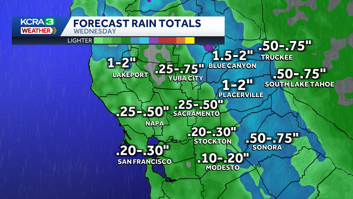
While November is off to a warm and pleasant start in Northern California, the KCRA weather team is tracking some big changes for the upcoming week. Wednesday will be KCRA 3 weather Impact Day. Steady rain will be a nuisance for drivers and anyone with outdoor plans, particularly in the morning. Travelers in the Sierra should anticipate slick roads and possible chain controls over the Tahoe area summits.A weather system with lingering atmospheric river moisture has the potential to bring moderate rain, high elevation snow and breezy conditions to the region on Wednesday, Nov. 5, with showers lingering into early Thursday morning. The rain expected to begin to arrive to the region on Tuesday night. The KCRA 3 weather team is expecting between .25 inch and .75 inch for the Sacramento Valley with lower amounts south of Interstate 80 from Wednesday morning lasting into Wednesday evening. Rain amounts in the Foothills will be about double what’s expected in the Valley. Winds across the region will be strongest Wednesday morning, sustained at 10-20 mph and gusting to 30 mph. Exact forecast amounts and the expected arrival times of wet weather may change as new model data comes in. A few inches of snow are in the forecast for the Sierra, mainly on Wednesday, but the snow level will likely be on the high side, 7,500 feet and above. Anyone with plans to travel in the Sierra on Wednesday or Thursday should monitor the forecast over the next few days and prepare for possible travel delays over the passes.REAL-TIME TRAFFIC MAPClick here to see our interactive traffic map.TRACK INTERACTIVE, DOPPLER RADARClick here to see our interactive radar.DOWNLOAD OUR APP FOR THE LATESTHere is where you can download our app.Follow our KCRA weather team on social mediaMeteorologist Tamara Berg on Facebook and X.Meteorologist Dirk Verdoorn on FacebookMeteorologist Heather Waldman on Facebook and X.Meteorologist Kelly Curran on X.Meteorologist Ophelia Young on Facebook and X.Watch our forecasts on TV or onlineHere’s where to find our latest video forecast. You can also watch a livestream of our latest newscast here. The banner on our website turns red when we’re live.We’re also streaming on the Very Local app for Roku, Apple TV or Amazon Fire TV.See more coverage of top California stories here | Download our app | Subscribe to our morning newsletter | Find us on YouTube here and subscribe to our channel
While November is off to a warm and pleasant start in Northern California, the KCRA weather team is tracking some big changes for the upcoming week.
Wednesday will be KCRA 3 weather Impact Day. Steady rain will be a nuisance for drivers and anyone with outdoor plans, particularly in the morning. Travelers in the Sierra should anticipate slick roads and possible chain controls over the Tahoe area summits.
A weather system with lingering atmospheric river moisture has the potential to bring moderate rain, high elevation snow and breezy conditions to the region on Wednesday, Nov. 5, with showers lingering into early Thursday morning. The rain expected to begin to arrive to the region on Tuesday night.
The KCRA 3 weather team is expecting between .25 inch and .75 inch for the Sacramento Valley with lower amounts south of Interstate 80 from Wednesday morning lasting into Wednesday evening. Rain amounts in the Foothills will be about double what’s expected in the Valley. Winds across the region will be strongest Wednesday morning, sustained at 10-20 mph and gusting to 30 mph.

Exact forecast amounts and the expected arrival times of wet weather may change as new model data comes in.
A few inches of snow are in the forecast for the Sierra, mainly on Wednesday, but the snow level will likely be on the high side, 7,500 feet and above. Anyone with plans to travel in the Sierra on Wednesday or Thursday should monitor the forecast over the next few days and prepare for possible travel delays over the passes.

REAL-TIME TRAFFIC MAP
Click here to see our interactive traffic map.
TRACK INTERACTIVE, DOPPLER RADAR
Click here to see our interactive radar.
DOWNLOAD OUR APP FOR THE LATEST
Here is where you can download our app.
Follow our KCRA weather team on social media
Meteorologist Tamara Berg on Facebook and X.Meteorologist Dirk Verdoorn on FacebookMeteorologist Heather Waldman on Facebook and X.Meteorologist Kelly Curran on X.Meteorologist Ophelia Young on Facebook and X.
Watch our forecasts on TV or online
Here’s where to find our latest video forecast. You can also watch a livestream of our latest newscast here. The banner on our website turns red when we’re live.
We’re also streaming on the Very Local app for Roku, Apple TV or Amazon Fire TV.
See more coverage of top California stories here | Download our app | Subscribe to our morning newsletter | Find us on YouTube here and subscribe to our channel