
Wildfires may happen more often during the summer and early fall, but they can happen any time of the year in California. (Video Above: Watch our August 2025 Wildfire Ready special report.)Cal Fire, the state’s wildfire management agency, said its seasonal outlook for Northern California shows that significant fire potential is expected to increase above normal through July, when lightning that month could remain a “key forecast wildcard.”However, Cal Fire and other fire agencies say there are some things you can do to keep yourself and your loved ones safe. This guide provides links to our wildfire coverage with information on what to know before and during a fire.One thing you can do right now is to download our news app to get the latest push notifications on wildfires and time-sensitive safety information. You can also follow us on social media, as we livestream much of our aerial fire coverage from LiveCopter 3.WHERE TO FIND COUNTY EVACUATION INFO AND HOW TO SIGN UP FOR EMERGENCY ALERTSHere is a county-by-county resources list for KCRA 3’s coverage area to help you find important information and updates in the event of a wildfire in Northern California. This guide includes links to the websites for county offices of emergency services and law enforcement and fire agencies. It also includes where to sign up for county emergency alert notifications now and find maps that counties will use to share evacuation updates during fires.Genasys Protect is used by public safety agencies in about three dozen counties to show areas covered by evacuation orders and warnings. You can search evacuation information by address on their website or on their mobile app.There is full coverage for these counties: Del Norte, Siskiyou, Modoc, Humboldt, Shasta, Lassen, Tehama, Plumas, Mendocino, Sierra, Lake, Yuba, Nevada, Sutter, Napa, Yolo, Marin, Contra Costa, Solano, San Mateo, Alameda, Santa Cruz, Calaveras, Mono, Madera, Tulare, Inyo, Monterey, Kern, Los Angeles, Riverside, San Diego.There is some coverage for these counties: San Luis Obispo, San Francisco, San Joaquin, and Santa Clara.MORE | Cal Fire’s tips to prepare for California’s wildfire seasonTRACK WILDFIRES NEAR YOUThose who live in wildfire-prone areas should sign up for Cal Fire alerts to know immediately if one sparks nearby. The county resources list also provides information on how to sign up for alerts based on your county of residence. Residents can also access wildfire maps to stay in the know about wildfires in the area. The Watch Duty app is another good resource to track wildfires in real time. (Learn more about this resources further below in the guide). Fire maps from government agencies and a network of cameras across the state:Cal Fire Active Fires of InterestFederal Incident Information SystemFind public information about fires in national forestsSee ALERTCalifornia cameras across California that are used to detect wildfiresSee a map of active wildfires in California from our partners with the San Francisco Chronicle below. Another way to track wildfiresCal Fire this year released an “Incident Updates” section for its wildland fire status reports. They can be found in the incident report for each wildfire, offering a timestamp of when the update was released.The image below is an example of Cal Fire’s wildfire blog, with entries shown from the Lost Fire burning in Kern County.KCRA 3’S FIRE THREAT INDEXThe KCRA 3 weather team has developed its exclusive Fire Threat Index to help you understand when weather conditions are increasing the risk for a wildfire.Weather conditions and the amount of moisture in vegetation vary greatly across Northern California, so the Fire Threat Index is broken down into four regions: the Valley, the Foothills, the Sierra and the Coastal Hills.Each day, the KCRA 3 weather team analyzes three important wildfire weather factors: fuel moisture, humidity and wind strength. Those three factors are used to determine a region’s expected wildfire risk over the next four days.Read more here.CALIFORNIA’S WILDFIRE SEVERITY MAPSAn executive order by Gov. Gavin Newsom aims to ramp up fire safety in urban areas of the Golden State, as maps released in 2025 revealed more than 1 million acres are at a higher risk of wildfires.The updated hazard zones are not intended to assess the current “risk” of wildfire damage but take a longer view of conditions, according to the State Fire Marshal.“’Hazard’ is based on the physical conditions that create a likelihood and expected fire behavior over a 30 to 50-year period without considering mitigation measures such as home hardening, recent wildfire, or fuel reduction efforts,” Cal Fire says. “‘Risk’ is the potential damage a fire can do to the area under existing conditions, accounting for any modifications such as fuel reduction projects, defensible space, and ignition-resistant building construction.”Previously, Cal Fire’s fire hazard maps only had a “very high” category. The new maps now include a “high” and “moderate” category. Under the new category, the state found that about 1.4 million new acres of land should be included under the two highest tiers of fire severity.Learn more and view the maps here. WHAT TO DO WHEN UNDER EVACUATION WARNINGSSome California residents may see their homes and neighborhoods under an evacuation warning this fire season.Residents are not required to leave under an evacuation warning, but officials recommend people be ready to do so at a moment’s notice in case wildfire conditions suddenly become life-threatening.Although no one wants to find themselves and their families in this position, it’s important to be prepared and have a plan ahead of time in case wildfire behavior becomes life-threatening.Cal Fire will send you information if there is a wildfire near you. Sign up for those alerts here. In addition to that, Cal Fire also recommends remembering “The Six Ps:”People and petsPapers, phone numbers and important documentsPrescriptions, vitamins and eyeglassesPictures and irreplaceable memorabiliaPersonal computer hard drive and disks”Plastic” (credit cards, ATM cards) and cash| MORE | When to evacuate a wildfire? Cal Fire chief’s advice to help protect you and emergency crewsHOME HARDENING TIPSThere are different ways your home can be damaged by wildfire: Direct flames from a wildfire or a neighbor’s burning home, radiant heat from nearby burning plants or structures and flying embers. Cal Fire says embers are responsible for most destruction to homes during a wildfire.With that in mind, it’s important that Californians, particularly those who live in wildfire-prone areas, take precautions to harden their homes.Some of those precautions include protecting your roof, covering vents to prevent embers, and maintaining driveways and access to roads.Find tips from Cal Fire here. RELATED | Gov. Newsom wants to speed up rule making California homes more fire-resistantRELATED | How a California home-hardening company is helping with defensible space WHAT DO I PUT IN MY GO BAGS?California officials recommend keeping an emergency supply kit ready in case of a wildfire, earthquake or another disaster.Cal Fire recommends that you store the kit of essentials in a backpack and also have a three-day supply of food and water ready to go in a tub or chest on wheels. Don’t forget baby formula if you need it, and food and water for your pets.In case of an evacuation at night, it’s also good to have a pair of shoes and a flashlight near your bed.RELATED | 5 quick and easy tips to prepare for a wildfireUNDERSTANDING WHAT FIRE TERMS MEANFlare-ups? Containment? Evacuation warnings versus evacuation orders? The best starting point in protecting your family against wildfires is understanding what some of these commonly used terms really mean. Find a full list here.VIDEO BELOW: Cal Fire launches online platform for viewing vegetation management programsHOW CONTAINMENT PLAYS A ROLE IN FIGHTING A FIRECalifornians are by now familiar with how vicious wildfires have become. Fires are not only burning hotter, but they are spreading more quickly as well.So how do people know when fire crews gain the upper hand in putting out a wildfire? Generally, people will pay attention to two numbers: acreage and containment.Acreage measures not the current size of the fire, but how many acres it has burned. Then there’s containment. Some people might turn to containment and view 100% as meaning the fire is out. That would be incorrect.Containment itself refers to a barrier, whether it be natural or manmade, that prevents a wildfire from spreading.There are multiple ways to gauge how fast fires are spreading, or if crews are getting a good handle on extinguishing them.When looking at acreage updates, if the numbers are drastically increasing, that could indicate that the fire is still rapidly spreading. However, if the acreage does not dramatically change, that could indicate that crews are either slowing the spread or have stopped it altogether.Another method of knowing where a fire stands is if officials announce that forward progress has stopped. That means crews have stopped the spread of flames in at least one direction.Here’s an explainer of how fire officials use containment when determining where they are in extinguishing wildfires.WHAT IS CALIFORNIA’S FAIR PLAN?The California FAIR Plan is a type of wildfire insurance for people who are not able to find other insurance due to their home’s fire risk.Typically, the FAIR Plan is much more expensive than regular wildfire insurance and should be used only as a last resort.”The FAIR Plan ultimately is intended to be a short-term solution for the marketplace. It is more expensive because the majority of the risks, are more risky,” said Phil Irwin, public relations representative for the California FAIR Plan.Read more about the California FAIR Plan here.HOW TO TRACK AIR QUALITYKnowing the expected levels of air quality conditions where you are can help you plan and make the best possible decisions for you and your family during wildfire season.If you want to focus on smoke pollution specifically, PurpleAir makes a home device. But you don’t have to purchase one in order to take advantage of air quality data from PurpleAir.WATCH DUTY, ANOTHER WAY TO TRACK WILDFIRESWatch Duty, a smartphone app that surged in relevancy during the Mosquito Fire in 2022, continues to serve as an easy way to track wildfires across California.John Clarke Mills, co-founder and CEO of Watch Duty, said the app relies on information from a team of people who have been listening to fire and police scanner radio transmissions for years in California.Here’s how Watch Duty explains its mission on its website: “When a wildfire ignites we are automatically notified and start gathering information from a wide variety of public sources including local, state, and federal fire frequencies, satellite and infrared flight data, fixed and aerial imagery, and more.”The Watch Duty team then works to validate, organize and share that information as early as possible.Mills stressed that the app should not be considered a substitute for emergency alert systems like Nixle.Read the full story here. HOW DID YOU DO ON OUR WILDFIRE QUIZ? MORE WILDFIRE RESOURCESCal FireU.S. Forest ServiceFEMAReady.GovDisasterAssistance.govCal OES Emergency Preparedness PageSee more coverage of top California stories here | Download our app | Subscribe to our morning newsletter | Find us on YouTube here and subscribe to our channel
Wildfires may happen more often during the summer and early fall, but they can happen any time of the year in California.
(Video Above: Watch our August 2025 Wildfire Ready special report.)
Cal Fire, the state’s wildfire management agency, said its seasonal outlook for Northern California shows that significant fire potential is expected to increase above normal through July, when lightning that month could remain a “key forecast wildcard.”
However, Cal Fire and other fire agencies say there are some things you can do to keep yourself and your loved ones safe.
This guide provides links to our wildfire coverage with information on what to know before and during a fire.
One thing you can do right now is to download our news app to get the latest push notifications on wildfires and time-sensitive safety information. You can also follow us on social media, as we livestream much of our aerial fire coverage from LiveCopter 3.
WHERE TO FIND COUNTY EVACUATION INFO AND HOW TO SIGN UP FOR EMERGENCY ALERTS
Here is a county-by-county resources list for KCRA 3’s coverage area to help you find important information and updates in the event of a wildfire in Northern California.
This guide includes links to the websites for county offices of emergency services and law enforcement and fire agencies.
It also includes where to sign up for county emergency alert notifications now and find maps that counties will use to share evacuation updates during fires.
Genasys Protect is used by public safety agencies in about three dozen counties to show areas covered by evacuation orders and warnings. You can search evacuation information by address on their website or on their mobile app.
There is full coverage for these counties: Del Norte, Siskiyou, Modoc, Humboldt, Shasta, Lassen, Tehama, Plumas, Mendocino, Sierra, Lake, Yuba, Nevada, Sutter, Napa, Yolo, Marin, Contra Costa, Solano, San Mateo, Alameda, Santa Cruz, Calaveras, Mono, Madera, Tulare, Inyo, Monterey, Kern, Los Angeles, Riverside, San Diego.
There is some coverage for these counties: San Luis Obispo, San Francisco, San Joaquin, and Santa Clara.
MORE | Cal Fire’s tips to prepare for California’s wildfire season
TRACK WILDFIRES NEAR YOU
Those who live in wildfire-prone areas should sign up for Cal Fire alerts to know immediately if one sparks nearby. The county resources list also provides information on how to sign up for alerts based on your county of residence. Residents can also access wildfire maps to stay in the know about wildfires in the area. The Watch Duty app is another good resource to track wildfires in real time. (Learn more about this resources further below in the guide).
Fire maps from government agencies and a network of cameras across the state:
See a map of active wildfires in California from our partners with the San Francisco Chronicle below.
Another way to track wildfires
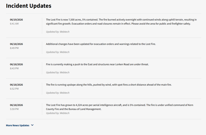
Cal Fire this year released an “Incident Updates” section for its wildland fire status reports. They can be found in the incident report for each wildfire, offering a timestamp of when the update was released.
The image below is an example of Cal Fire’s wildfire blog, with entries shown from the Lost Fire burning in Kern County.
KCRA 3’S FIRE THREAT INDEX
The KCRA 3 weather team has developed its exclusive Fire Threat Index to help you understand when weather conditions are increasing the risk for a wildfire.
Weather conditions and the amount of moisture in vegetation vary greatly across Northern California, so the Fire Threat Index is broken down into four regions: the Valley, the Foothills, the Sierra and the Coastal Hills.
Each day, the KCRA 3 weather team analyzes three important wildfire weather factors: fuel moisture, humidity and wind strength. Those three factors are used to determine a region’s expected wildfire risk over the next four days.
CALIFORNIA’S WILDFIRE SEVERITY MAPS
An executive order by Gov. Gavin Newsom aims to ramp up fire safety in urban areas of the Golden State, as maps released in 2025 revealed more than 1 million acres are at a higher risk of wildfires.
The updated hazard zones are not intended to assess the current “risk” of wildfire damage but take a longer view of conditions, according to the State Fire Marshal.
“’Hazard’ is based on the physical conditions that create a likelihood and expected fire behavior over a 30 to 50-year period without considering mitigation measures such as home hardening, recent wildfire, or fuel reduction efforts,” Cal Fire says. “‘Risk’ is the potential damage a fire can do to the area under existing conditions, accounting for any modifications such as fuel reduction projects, defensible space, and ignition-resistant building construction.”
Previously, Cal Fire’s fire hazard maps only had a “very high” category. The new maps now include a “high” and “moderate” category. Under the new category, the state found that about 1.4 million new acres of land should be included under the two highest tiers of fire severity.
Learn more and view the maps here.
WHAT TO DO WHEN UNDER EVACUATION WARNINGS
Some California residents may see their homes and neighborhoods under an evacuation warning this fire season.
Residents are not required to leave under an evacuation warning, but officials recommend people be ready to do so at a moment’s notice in case wildfire conditions suddenly become life-threatening.
Although no one wants to find themselves and their families in this position, it’s important to be prepared and have a plan ahead of time in case wildfire behavior becomes life-threatening.
Cal Fire will send you information if there is a wildfire near you. Sign up for those alerts here.
In addition to that, Cal Fire also recommends remembering “The Six Ps:”
People and petsPapers, phone numbers and important documentsPrescriptions, vitamins and eyeglassesPictures and irreplaceable memorabiliaPersonal computer hard drive and disks”Plastic” (credit cards, ATM cards) and cash
| MORE | When to evacuate a wildfire? Cal Fire chief’s advice to help protect you and emergency crews
HOME HARDENING TIPS
There are different ways your home can be damaged by wildfire: Direct flames from a wildfire or a neighbor’s burning home, radiant heat from nearby burning plants or structures and flying embers. Cal Fire says embers are responsible for most destruction to homes during a wildfire.
With that in mind, it’s important that Californians, particularly those who live in wildfire-prone areas, take precautions to harden their homes.
Some of those precautions include protecting your roof, covering vents to prevent embers, and maintaining driveways and access to roads.
RELATED | Gov. Newsom wants to speed up rule making California homes more fire-resistant
RELATED | How a California home-hardening company is helping with defensible space
WHAT DO I PUT IN MY GO BAGS?
California officials recommend keeping an emergency supply kit ready in case of a wildfire, earthquake or another disaster.
Cal Fire recommends that you store the kit of essentials in a backpack and also have a three-day supply of food and water ready to go in a tub or chest on wheels. Don’t forget baby formula if you need it, and food and water for your pets.
In case of an evacuation at night, it’s also good to have a pair of shoes and a flashlight near your bed.
RELATED | 5 quick and easy tips to prepare for a wildfire
UNDERSTANDING WHAT FIRE TERMS MEAN
Flare-ups? Containment? Evacuation warnings versus evacuation orders? The best starting point in protecting your family against wildfires is understanding what some of these commonly used terms really mean. Find a full list here.
VIDEO BELOW: Cal Fire launches online platform for viewing vegetation management programs
HOW CONTAINMENT PLAYS A ROLE IN FIGHTING A FIRE
Californians are by now familiar with how vicious wildfires have become. Fires are not only burning hotter, but they are spreading more quickly as well.
So how do people know when fire crews gain the upper hand in putting out a wildfire? Generally, people will pay attention to two numbers: acreage and containment.
Acreage measures not the current size of the fire, but how many acres it has burned. Then there’s containment. Some people might turn to containment and view 100% as meaning the fire is out. That would be incorrect.
Containment itself refers to a barrier, whether it be natural or manmade, that prevents a wildfire from spreading.
There are multiple ways to gauge how fast fires are spreading, or if crews are getting a good handle on extinguishing them.
When looking at acreage updates, if the numbers are drastically increasing, that could indicate that the fire is still rapidly spreading. However, if the acreage does not dramatically change, that could indicate that crews are either slowing the spread or have stopped it altogether.
Another method of knowing where a fire stands is if officials announce that forward progress has stopped. That means crews have stopped the spread of flames in at least one direction.
WHAT IS CALIFORNIA’S FAIR PLAN?
The California FAIR Plan is a type of wildfire insurance for people who are not able to find other insurance due to their home’s fire risk.
Typically, the FAIR Plan is much more expensive than regular wildfire insurance and should be used only as a last resort.
“The FAIR Plan ultimately is intended to be a short-term solution for the marketplace. It is more expensive because the majority of the risks, are more risky,” said Phil Irwin, public relations representative for the California FAIR Plan.
Read more about the California FAIR Plan here.
HOW TO TRACK AIR QUALITY
Knowing the expected levels of air quality conditions where you are can help you plan and make the best possible decisions for you and your family during wildfire season.
If you want to focus on smoke pollution specifically, PurpleAir makes a home device. But you don’t have to purchase one in order to take advantage of air quality data from PurpleAir.
WATCH DUTY, ANOTHER WAY TO TRACK WILDFIRES
Watch Duty, a smartphone app that surged in relevancy during the Mosquito Fire in 2022, continues to serve as an easy way to track wildfires across California.
John Clarke Mills, co-founder and CEO of Watch Duty, said the app relies on information from a team of people who have been listening to fire and police scanner radio transmissions for years in California.
Here’s how Watch Duty explains its mission on its website: “When a wildfire ignites we are automatically notified and start gathering information from a wide variety of public sources including local, state, and federal fire frequencies, satellite and infrared flight data, fixed and aerial imagery, and more.”
The Watch Duty team then works to validate, organize and share that information as early as possible.
Mills stressed that the app should not be considered a substitute for emergency alert systems like Nixle.
HOW DID YOU DO ON OUR WILDFIRE QUIZ?
MORE WILDFIRE RESOURCES
See more coverage of top California stories here | Download our app | Subscribe to our morning newsletter | Find us on YouTube here and subscribe to our channel