
Northern California forecast: Warm Wednesday, but cooling begins Thursday
Another day of pleasant summer weather is on the way, starting with a comfortable morning, followed by a warm afternoon, ending with an evening breeze.
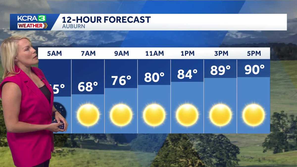
I’M IVAN RODRIGUEZ, REPORTING. 419 NOW ON THIS WEDNESDAY MORNING. PRETTY PLEASANT START TO THE DAY AS WE TAKE A LIVE LOOK HERE FROM OUR LAKE TAHOE SKY CAMERA. LET’S HEAD RIGHT NOW TO METEOROLOGIST TAMARA BERG FOR MORE ON WHAT WE CAN EXPECT TODAY. BEAUTIFUL. CLEAR. STARLIT MORNING THERE IN THE SIERRA AND HERE IN THE VALLEY. THIS IS WHAT IT LOOKS LIKE IS DROP INTO THE VALLEY FLOOR. LIVE LOOK IN RANCHO CORDOVA FROM SACRAMENTO COUNTY. VANTAGE POINT. TEMPERATURES 50 IS COMFORTABLE, 57 IN SACRAMENTO 59. GETTING YOUR MORNING STARTED IN STOCKTON, 64 IN MODESTO AND CURRENTLY 47 IN SOUTH LAKE TAHOE. BIG WIDE VIEW HERE ACROSS THE GOLDEN STATE. YOU CAN SEE THAT THE MARINE LAYER IS THE MOST PRONOUNCED THING. THAT’S THE VISUAL. AS YOU LOOK AT THE SATELLITE RUN. AND WITH THAT MARINE LAYER AND THE COOLANT IN THE TANK AND A NICE DELTA BREEZE ON TOP OF IT, REALLY, NATURE’S AC IS REALLY, REALLY HELPING OUT AGAIN. THAT’S THE MARINE LAYER POINTED OUT, AND WE’RE SEEING SOME OF IT OOZE AS WELL INTO SOME OF THE NORTH AND EAST BAY SPOTS TODAY, MARKING THE 24TH DAY OF JUNE. AND WE’RE COMING IN RIGHT ON TARGET. WHAT DOES THAT MEAN? WELL, THE NORMAL HIGH THIS TIME OF YEAR IS 90 DEGREES. AND THAT IS OUR NUMBER FOR TODAY. SO SEASONABLE WEDNESDAY IS UNDERWAY AND WE HAVE A TRANSITION DAY ON THURSDAY AS WE’RE GOING TO SEE THOSE NUMBERS KIND OF EASE BACK INTO THE 80S. AND THEN IT’S GOING TO BE A BREEZY WEEKEND AHEAD WITH TEMPERATURES SLIDING BELOW NORMAL. LET’S FIRST GET YOU THROUGH YOUR WEDNESDAY. SO WHAT IS SEASONABLE LOOK LIKE? WELL, AGAIN, WE’RE GOING TO BE SEEING A STEADY STREAM HERE OF THE 50S, LIKELY THROUGH ABOUT THE 8:00 TIME FRAME IN THE VALLEY, LOWER 80S AROUND LUNCH AND HIGH TODAY, ABOUT 90. THE WORST PART OF THE HEAT TODAY IS THOSE HOURS BETWEEN ABOUT 4 P.M. AND 6 P.M. THAT’S WHEN WE’RE STARTING TO GET TOWARDS THAT 90. AND FOR THE FOOTHILLS, WE’RE LOOKING AT UPPER 60S AROUND 7:00 THIS MORNING, LOW 80S AROUND MIDDAY WITH HIGHS PROGRESSING ALSO TO ABOUT 90 DEGREES. AND TODAY IN THE SIERRA, A BEAUTIFUL DAY AHEAD. NICE CHILL IN THE MORNING. BUT THEN THE AFTERNOON. IT’S REALLY NICE AND WARM WITH TEMPERATURES CLOSE TO ABOUT 80 DEGREES. NOW AS WE GET IN THROUGH THE DAY TODAY, AGAIN, THIS RIDGE IS STILL KIND OF A BIG INFLUENCER FOR US, BUT IT’S GOING TO BE BREAKING DOWN AND WEAKENING, ALLOWING THIS SYSTEM TO DIG IN FROM THE NORTH, ENHANCING THE DELTA BREEZE. SO THAT’S WHY TOMORROW IS KIND OF OUR TRANSITION DAY. NUMBERS COME DOWN A LITTLE BIT IN TERMS OF DAYTIME HIGHS, BUT THEN A BIGGER DROP IS ANTICIPATED AS THIS SYSTEM COMPLETELY DIGS IN FRIDAY AND INTO SATURDAY. AND AS THAT TROUGH GOES BY, IT’S GOING TO SIGNAL AGAIN SOME COOLER AIR. SO THAT’S WHY OUR TEMPERATURES WILL SLIDE BELOW NORMAL JUST IN TIME FOR THE WEEKEND. IT DOES COME WITH A BIT OF A BREEZE THOUGH. IT IS GOING TO GET GUSTY AT TIMES. IF YOU HAVE OUTDOOR PLANS DURING THE DAY, FRIDAY OR SATURDAY AFTERNOON. SOMETHING TO PLAN FOR TEMPERATURE WISE. REALLY NICE WEEKEND TOO. IT DOESN’T GET ANY BETTER THAN THIS FOR GETTING INTO LATE PARTS OF JUNE 80S THROUGH THE WEEKEND, AND THEN NEXT WEEK WE’LL TURN IT BACK TO LOWER 90S. WOW, THAT’S QUITE A DIP. AGAIN, SAVOR THIS AND WE’LL SEE IF WE CAN KIND OF MAINTAIN THIS
Northern California forecast: Warm Wednesday, but cooling begins Thursday
Another day of pleasant summer weather is on the way, starting with a comfortable morning, followed by a warm afternoon, ending with an evening breeze.

Updated: 6:50 AM PDT Jun 24, 2026
A cool Delta breeze and mostly clear skies on Wednesday will keep the Northern California morning comfortable before sunshine pushes valley highs into the low 90s this afternoon.
A cooler pattern will continue through the rest of the week as onshore flow strengthens, with a trough arriving Friday to bring breezy conditions, cooler air and a slight chance of showers in the Northern Sierra.
Behind the system, north winds will gradually increase and raise fire danger across the region again.
Wednesday Forecast
A cool Delta breeze will be around this morning under mostly clear skies.
By the afternoon, plenty of sunshine will push temperatures back up to near normal, with highs reaching the low 90s in the valley.
Cooler temperature trend
A cooler trend is expected to continue the rest of this week, as our onshore breeze becomes more noticeable, especially in the afternoons.
Next weather system
Weather becomes more unsettled this Friday as a trough is expected to arrive.
As the system approaches from the Pacific, it will enhance our westerly winds and usher in even cooler air.
Breezy Friday
The Valley will end the work week with a breezy Friday as the weather system enhances our onshore flow.
Foothills & Sierra 7-day forecast
Sierra breezes are also expected to increase as early as Thursday, and a few mountain showers are possible in the Northern Sierra on Friday.
Valley 7-day forecast
While the disturbance will mitigate the warmth, it will be breezy with winds gradually filling in out of the north behind the departing trough, once again raising fire danger across the region.