
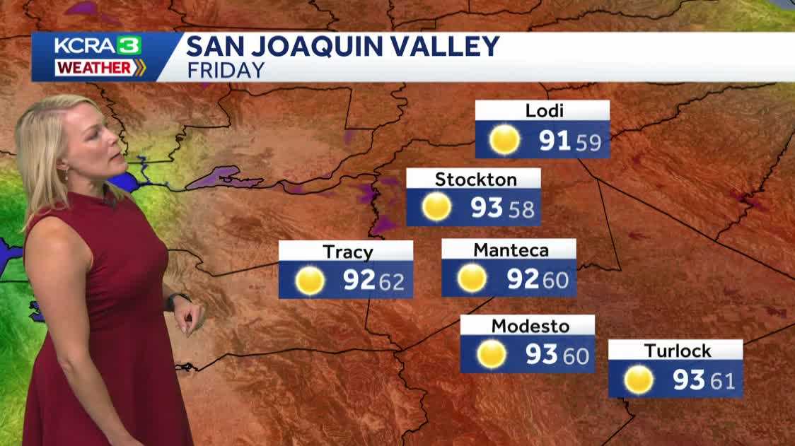
OF GRADUALLY SUBSIDE INTO THE LATTER HALF OF THE WEEKEND AND BEYOND. LIVE LOOK OUTSIDE FOR YOU IN STOCKTON NOTHING BUT BLUE SKIES. WHAT YOU’RE WAKING UP TO MID 50S HERE ON THE WEST COAST. STOCKTON AT 56 MODESTO 59. AND WE’RE AT 41 IN LAKE TAHOE. AND OF COURSE, TODAY IS 4TH OF JULY EVE. IT IS THE 3RD OF JULY. AND WE’RE EXPECTING A HIGH OF 92 DEGREES. THAT’S ON PAR FOR WHERE WE SHOULD BE THIS TIME OF YEAR. NOW, IN THE AFTERNOON, ONE THING TO KEEP AN EYE ON WILL BE A FEW PASSING SHOWERS AND THUNDERSTORMS, MAINLY SOUTH OF HIGHWAY 50, AND THEN LOOKING AHEAD TO TOMORROW MORNING FOR THOSE PARADES AND FESTIVITIES OUTDOORS. GREAT SHAPE. IT WILL BE COMFORTABLE. THEN BY 9:00 FOR THOSE FIREWORKS DISPLAYS, HOW DOES YOUR SKY LOOK? THE CONDITIONS ARE GOING TO BE MAINLY CLEAR. THE ONLY SPOT THAT MAY SEE KIND OF A FLY IN THE OINTMENT IS GOING TO BE ALONG THE COAST. IF YOU’RE TRYING TO WATCH A FIREWORKS DISPLAY FROM SAN FRANCISCO, HIGHS TODAY, UPPER 70S, LOW 80S IN TRUCKEE AND TAHOE. IT’S GOING TO BE WARM TODAY IN QUINCY AND 92 WE’LL GET TO 80 FOR GRASS VALLEY, 88 ANGELS CAMP PAPA MURPHY’S AND A GORGEOUS DAY IN THE MOTHERLODE CLOSE TO 90 FOR YOU IN SONORA 68 SAN FRANCISCO, UPPER 80S IN FAIRFIELD. I DEFINITELY ADVISE GRABBING LAYERS IF YOU’RE GOING TO THE CITY FOR THE HOLIDAY WEEKEND. 92 FOR YOU. TRACY 91 IN LODI. PLENTY OF SUNSHINE IN THE SACRAMENTO VALLEY IN THE SUBURBS. 90 TODAY IN DAVIS, 93 IN ROSEVILLE, 92 IN FOLSOM. SO AGAIN, ANY STORMS THAT ARE UP IN THE SIERRA MAINLY WILL BE SOUTH OF THE 50 STRETCH. WE’RE IN THE 80S IN THE HIGH COUNTRY THROUGH THE WEEKEND. AND FOR THE VALLEY, THAT MEANS 90S COULD SEE A BRI
Northern California forecast: Classic summer heat arrives for Fourth of July weekend
Friday will be warm and pleasant, and the Fourth of July looks great with sunny skies followed by a comfortable evening for fireworks.

Updated: 6:38 AM PDT Jul 3, 2026
It’s a pleasant start to Friday across the Sacramento region, with clear skies, a light breeze, and cool morning temperatures helping ease into the day. After the recent stretch of mild weather, temperatures are expected to return to seasonable values this afternoon. Friday’s Valley high in Sacramento is forecast to reach 92 degrees, right on par with the normal high for this time of year. A few clouds may linger at times, and there is a slight chance of an isolated thunderstorm in the Sierra, mainly south of Highway 50.Temperatures climb a bit for Independence Day on Saturday. Morning temperatures will begin in the low 60s, followed by a warm afternoon and a pleasant evening for fireworks. Conditions are expected to stay dry with light winds across much of the region.The warm pattern continues through the rest of the weekend, with weather slightly cooler on Sunday. A few clouds may return Sunday, but temperatures should still remain in the upper 80s to low 90s through at least Wednesday of next week.Overall, next week looks fairly quiet, with no major weather changes expected and daytime highs hovering close to July normals. Looking further ahead, there are early signs that bigger heat could return by next weekend.See more coverage of top California stories here | Download our app | Subscribe to our morning newsletter | Find us on YouTube here and subscribe to our channel | Make KCRA a preferred news source in Google
SACRAMENTO, Calif. —
It’s a pleasant start to Friday across the Sacramento region, with clear skies, a light breeze, and cool morning temperatures helping ease into the day.
After the recent stretch of mild weather, temperatures are expected to return to seasonable values this afternoon. Friday’s Valley high in Sacramento is forecast to reach 92 degrees, right on par with the normal high for this time of year.
A few clouds may linger at times, and there is a slight chance of an isolated thunderstorm in the Sierra, mainly south of Highway 50.
Temperatures climb a bit for Independence Day on Saturday. Morning temperatures will begin in the low 60s, followed by a warm afternoon and a pleasant evening for fireworks. Conditions are expected to stay dry with light winds across much of the region.
The warm pattern continues through the rest of the weekend, with weather slightly cooler on Sunday. A few clouds may return Sunday, but temperatures should still remain in the upper 80s to low 90s through at least Wednesday of next week.
Overall, next week looks fairly quiet, with no major weather changes expected and daytime highs hovering close to July normals. Looking further ahead, there are early signs that bigger heat could return by next weekend.
See more coverage of top California stories here | Download our app | Subscribe to our morning newsletter | Find us on YouTube here and subscribe to our channel | Make KCRA a preferred news source in Google