
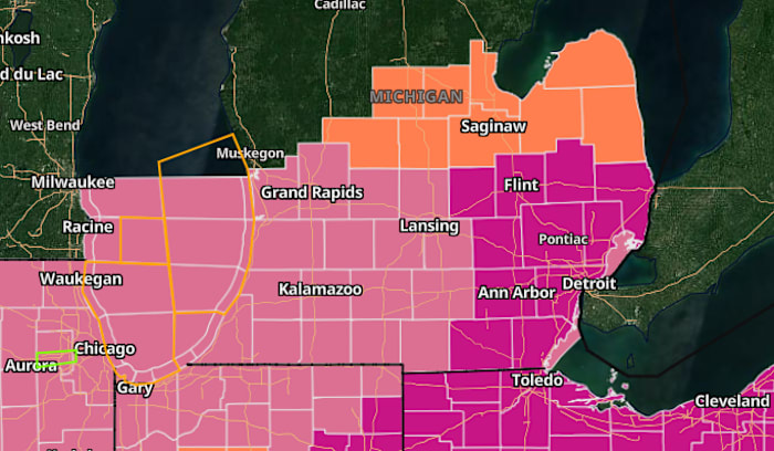
4Warn Weather – The National Weather Service has issued a severe thunderstorm warning for Oakland and Genesee counties as a line of strong storms moves across southeast Michigan, bringing the threat of damaging winds, hail and heavy rain.
The warning is in effect until 7:15 p.m. Friday.
At 6:10 p.m., forecasters said severe thunderstorms were located along a line extending from near Byron to Oak Grove and Brighton, moving east at about 50 mph.
The storms were capable of producing wind gusts up to 70 mph and nickel-size hail, according to radar indications.
The National Weather Service said the storms could cause considerable tree damage, with additional damage possible to mobile homes, roofs and outbuildings.
Communities expected to be impacted include South Lyon, Linden and Gaines around 6:15 p.m.; Novi, Fenton, Milford and Lake Fenton around 6:20 p.m.; and Holly around 6:25 p.m.
West Bloomfield was expected to see the storms around 6:30 p.m., followed by Southfield, Pontiac, Grand Blanc and Clarkston around 6:35 p.m. Troy, Royal Oak, Birmingham, Goodrich and Ortonville were expected around 6:40 p.m.
Warren, Oxford, Sterling Heights and Rochester were forecast to be impacted around 6:50 p.m.
Additional areas in the warning zone include Franklin, Keego Harbor, Waterford, Orchard Lake, Rankin, Holly State Recreation Area, Commerce, Rose Center, Lathrup Village and Auburn Hills.
Officials urged residents attending events such as Royal Oak Taco Fest, concerts at Pine Knob and Clawson’s Fourth of July celebration to seek shelter immediately.
The National Weather Service advised residents to move to an interior room on the lowest floor of a sturdy building and avoid driving through flooded roadways due to the risk of flash flooding.
The severe thunderstorm warning remains in effect until 7:15 p.m. unless it is extended or canceled.
Click here for the latest forecast from our 4Warn Weather team.
Here’s a list of the alerts by county.
Wayne County
Severe Thunderstorm Warning in effect through 7:15 p.m.
Oakland County
Severe Thunderstorm Warning in effect through 7:15 p.m.
Macomb CountyWashtenaw County
Severe Thunderstorm Warning in effect through 7:15 p.m.
Monroe County
Severe Thunderstorm Warning in effect through 7:15 p.m.
Livingston County
Severe Thunderstorm Warning in effect through 7:15 p.m.
Lenawee County
Severe Thunderstorm Warning in effect through 7:15 p.m.
Lapeer CountyGenesee County
Severe Thunderstorm Warning in effect through 7:15 p.m.
St. Clair CountySanilac County
Copyright 2026 by WDIV ClickOnDetroit – All rights reserved.