
NorCal forecast: Hotter & muggier starting this weekend
The next few days will feature the “typical” July warmth, but next week will be hotter and a little more humid for some as monsoon moisture moves in.
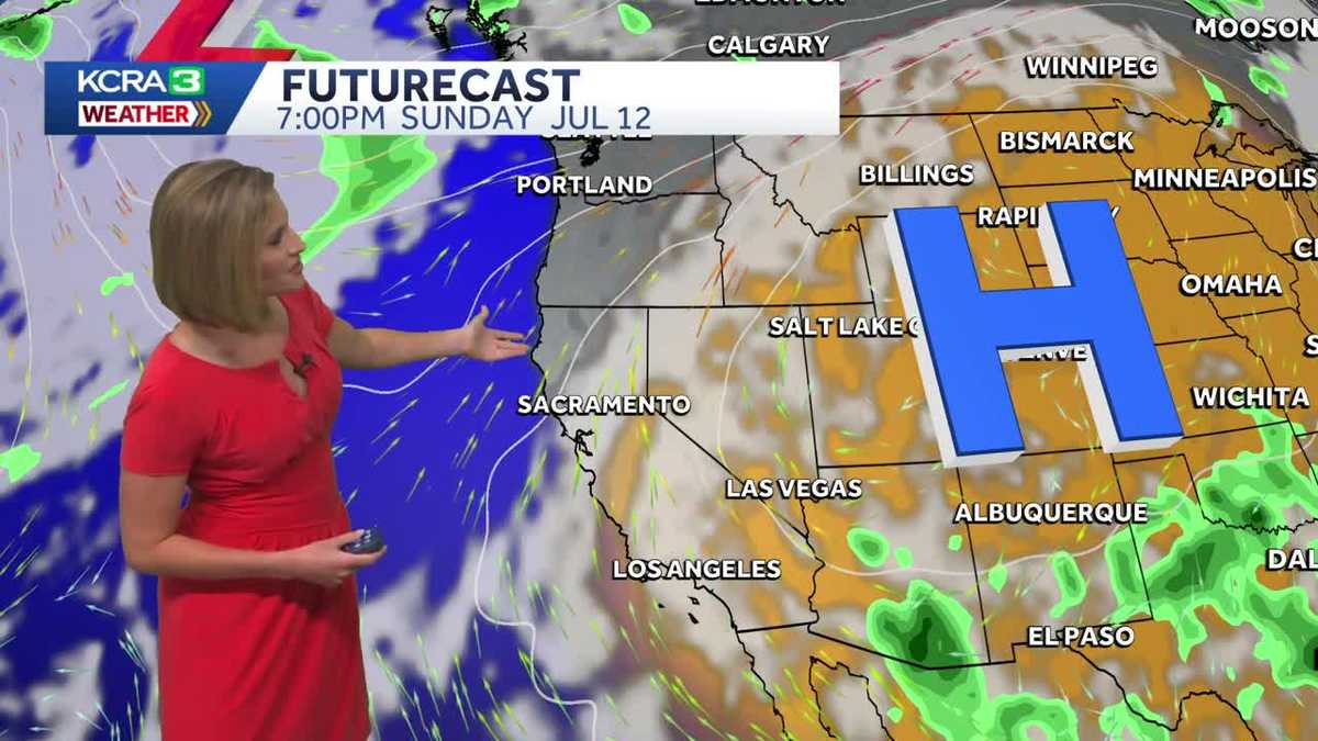
AT LAKE TAHOE. NICE AFTERNOON. AND LAKE TAHOE IS GETTING OVER TO OUR METEOROLOGIST HEATHER WALDMAN. YEAH. GORGEOUS DAY UP IN THE SIERRA. GORGEOUS DAY IN ROSEVILLE TO LIVECOPTER3 IS UP OVER SUNSPLASH. LOOKS LIKE THE WAVE POOL. NOT TOO CROWDED THIS AFTERNOON. I IMAGINE IT MIGHT BE THIS WEEKEND. TEMPERATURES RIGHT NOW RUNNING RIGHT AROUND 90 DEGREES IN ROSEVILLE. WE’RE JUST SHY OF THAT IN SACRAMENTO. IN STOCKTON. YOU GO TO THE EAST SIDE OF THE VALLEY. IT TENDS TO BE A LITTLE BIT WARMER, BUT WE’RE IN THE MID 80S IN THE FOOTHILLS, RIGHT AROUND 80 DEGREES UP IN THE SIERRA. AND NOTICE FAIRFIELD TODAY JUST ABOUT THE SAME TEMPERATURE. SACRAMENTO IN STOCKTON. WE DO NOT HAVE AS MUCH OF A DELTA BREEZE. SO THAT’S WHERE WE’RE SEEING THE BIGGEST CHANGES IN THOSE DELTA SPOTS, WHERE TEMPERATURES WERE HELD DOWN INTO THE LOW 80S YESTERDAY. FAIRFIELD UP TEN DEGREES FROM THIS TIME YESTERDAY. WE’RE UP EIGHT IN SACRAMENTO, WHILE THE FOOTHILLS AND THE SIERRA. NOT MUCH CHANGE FROM YESTERDAY. SO HERE’S A LOOK AT THE WINDS UNDER TEN MILES AN HOUR IN SACRAMENTO. ACTUALLY, MAYBE A LITTLE BIT OF A NORTH BREEZE IN SOME SPOTS THERE. BUT THE WINDS IN FAIRFIELD STILL BREEZY, STILL THERE. BUT YESTERDAY THEY WERE CLOSER TO 30MPH. TODAY A LITTLE BIT LESS, SO DOWN TO 20. HIGH PRESSURE OFF TO OUR SOUTH. WE TOLD YOU ABOUT THE HEAT IN SOUTHERN CALIFORNIA. THAT’S WHERE THIS IS COMING FROM. BUT BECAUSE WE’RE KIND OF ON THE NORTHERN EDGE OF THAT HIGH, WE STILL HAVE AT LEAST A LITTLE BIT OF ROOM FOR AN ONSHORE BREEZE. WE’RE NOT GETTING OFFSHORE WINDS. THAT WOULD CERTAINLY HEAT THINGS UP QUITE A BIT. BUT HERE’S WHAT’S GOING TO CHANGE OVER THE NEXT COUPLE OF DAYS. THIS HIGH IS GOING TO START TO MOVE BACK TO THE EAST. SO BY FRIDAY, LOW PRESSURE MOVING TO THE NORTH, THAT ACTUALLY INCREASES THE ONSHORE BREEZE AGAIN. SO NUMBERS GO UP A FEW DEGREES TOMORROW. BACK DOWN A FEW DEGREES ON FRIDAY. BUT THEN THEY GO RIGHT BACK UP FOR THE WEEKEND. THIS HIGH IS STILL WELL OFF TO OUR EAST, BUT IT’S GOING TO EXPAND. IT’S GOING TO BE VERY STRONG FOR THIS TIME OF THE YEAR AS WELL. ALSO NOTICE THE WAY THE WINDS ARE MOVING NOW COMING UP OUT OF THE SOUTH. SO THIS CLOUD COVER YOU SEE HERE ON SUNDAY, WE’VE BEEN TALKING ABOUT IT ALL WEEK. THAT WILL BE A LITTLE BIT OF MOISTURE FROM THE MONSOON. SO AN INCREASE IN THE CLOUDS ON SUNDAY. IT’S GOING TO KEEP TEMPERATURES FROM TAKING OFF TOO MUCH. MIGHT ALSO MAKE IT FEEL A LITTLE BIT MUGGIER ESPECIALLY IN THE MORNINGS, ESPECIALLY UP INTO THE SIERRA. BUT THIS IS WHAT WE’RE THINKING FOR SATURDAY AND FOR SUNDAY. DRY BOTH DAYS. SO GOOD DAYS TO DO SOMETHING OUTDOORS, BUT JUST MAKE SURE YOU’RE READY FOR WARMER CONDITIONS THAN WHAT WE’VE HAD OVER THE PAST FEW DAYS. TOMORROW IN THE SIERRA, BRIGHT AND SUNNY LIGHT WINDS, TEMPERATURES WILL BE IN THE MID 80S MID TO UPPER 80S IN POLLOCK PINES AND ARNOLD. YOSEMITE IN THE VALLEY GETS TO 92 DEGREES FOR THE FOOTHILLS TOMORROW. A LITTLE BIT WARMER THAN TODAY WILL BE IN THE LOWER 90S WITH MORNING TEMPERATURES IN THE LOWER 60S. THE MARINE LAYER IS STARTING TO THIN OUT. I THINK SAN FRANCISCO STARTS WITH SOME CLOUD COVER, BUT WE’LL END UP CLOSER TO 70 DEGREES TOMORROW AFTERNOON AND NEARING 90 IN FAIRFIELD AND CONCORD. SO A COUPLE DEGREES WARMER THAN TODAY AND WILL WARM THINGS UP FOR THE SAN JOAQUIN VALLEY AS WELL. THAT WILL PUT MOST SPOTS IN THE MID 90S FOR ABOUT AN HOUR OR TWO TOMORROW AFTERNOON. DELTA BREEZE WILL KICK IN TOMORROW EVENING. IT’S NOT GOING TO HAVE MUCH PUNCH TO IT. SO VACAVILLE GETS TO 94 DEGREES SACRAMENTO ALSO GETTING TO 94 DEGREES WITH A HIGH OF 97 IN FOLSOM. HERE’S A LOOK AT THE SEVEN DAY FORECAST WE’VE BEEN TALKING ABOUT NEXT WEEK. GETTING HOTTER. THAT’S WHAT’S GOING TO HAPPEN. WEATHER IMPACT DAYS FOR TUESDAY
Meteorologist/Climate Reporter
NorCal forecast: Hotter & muggier starting this weekend
The next few days will feature the “typical” July warmth, but next week will be hotter and a little more humid for some as monsoon moisture moves in.

Updated: 4:01 PM PDT Jul 8, 2026
Meteorologist/Climate Reporter
The Delta breeze on Monday is expected to continue influencing temperatures in Northern California to keep highs below average. Monday looks great for getting outdoors. The Delta breeze is helping to lower temperatures to start the work week. Valley highs are likely to be in the upper 80s to low 90s, while the Foothills could stay in the mid to upper 80s. The Sierra will see some afternoon clouds build with storm chances down the east slope, with highs in the low-to-mid 70s. Highs continue slightly below normal through Tuesday. Midweek, expect the heat to begin to build. Ridging begins to build from the Desert Southwest. As the ridge nudges closer to us, we will see Valley highs above average for this time of year starting Thursday. Feeling the heatPlan for highs across the valley from Thursday through Saturday, peaking in the upper 90s. The worst of the heat looks to hit on Thursday. Depending on where the ridge wobbles late next weekend, there’s a chance the heat could linger into the next work week.See more coverage of top California stories here | Download our app | Subscribe to our morning newsletter | Find us on YouTube here and subscribe to our channel | Make KCRA a preferred news source in Google
The rest of this week will have the typical dry warmth that comes with summer. Next week will feel hotter and muggier as monsoon moisture creeps up from the north.
Sunday will have plenty of clouds, but rain chances from monsoon showers will hold off until Monday. Even then, rain is most likely in the Sierra.
The potential for triple digit heat is increasing Tuesday and Wednesday of next week. Mornings will also be much warmer, especially in the Foothills. Both days are now KCRA 3 weather Impact Days.
Thursday forecast
Thursday morning will be comfortable, but there won’t be much of a breeze. That means the afternoon will be warmer than the past few days.
Temperature trend
The onshore breeze will increase a little for Friday and bring delta temperatures down several degrees. The weather will get warmer this weekend. Clouds will be widespread on Sunday. That will be monsoon moisture coming up from the southeast. Some may notice a muggier feel to the air going into next week.
Hotter & muggier next week
A monsoon pattern will impact Northern California’s weather for at least a few days next week. The means warm mornings that feel a little muggy, scattered clouds and chances for mountain thunder showers. Rain is possible Monday, Tuesday and Wednesday in the Sierra.
Impact Days: Heat intensifies next week
Valley temperatures are forecast to reach the triple digits Tuesday and Wednesday next week and highs in the Foothills will only be a few degrees lower. Mornings will also be very warm with winds coming from the southeast.
Foothills & Sierra 7 day forecast
This week is the typical dry summer warmth. Next week will be hotter and muggier with chances for Sierra thunderstorms, especially south of the Tahoe area.
Valley 7 day forecast
A delta breeze will keep Friday comfortable but the weekend will feel more stagnant, especially Sunday. Be ready for some hot days next week.