
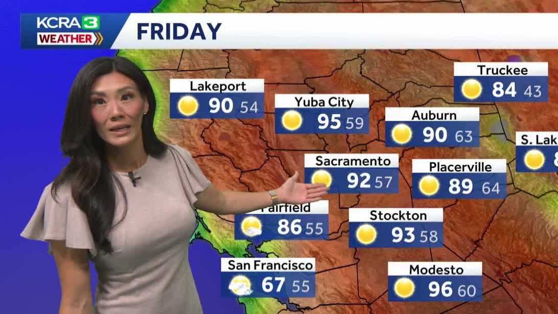
GERMAN SHEPHERD OR MALINOIS MALINOIS. THERE YOU ARE. ALL RIGHT, LET’S GET A CHECK ON OUR FORECAST. HOW ARE WE LOOKING FOR TODAY? I DON’T HAVE ANY ANIMAL NEWS FOR YOU. NO, WE KIND OF COVERED IT. BUT I DO HAVE NICE WEATHER FOR THE ANIMALS TO BE OUT. YES. YEAH, I CAN PULL THAT UP LATER ON. CAN’T. CAN’T PULL THAT OUT OF MY POCKET NOW. BUT IF YOU’RE GOING TO BE WALKING YOUR DOG, IT’S VERY COMFORTABLE. HOT TEMPERATURES AROUND 60 DEGREES IN THE VALLEY. THE WINDS ARE LIGHT FOR NOW. IF YOU’RE WALKING IN THE FOOTHILLS. 72 AND IN THE SIERRA LOW 40S. YOU’LL NEED A LIGHT LAYER IN. IN THE AFTERNOON, A BREEZE IS GOING TO PICK UP. AND JUST BECAUSE TODAY IS STARTING OFF A LITTLE COMFORTABLE. AND BY THAT I MEAN A LITTLE WARMER DOES ALSO MEAN DOES NOT MEAN THAT IT’S GOING TO END UP A LITTLE WARMER. TEMPERATURES ARE ACTUALLY GOING TO TREND DOWN TODAY AND WILL ONLY END UP AT 92 DEGREES IN THE VALLEY IN ARDEN AND PLACERVILLE, UPPER 80S AND LOW 90S FOR THE HIGH IN THE SIERRA, TEMPERATURES WARMING INTO THE LOW 80S. SO WHAT’S GOING ON TO CAUSE THIS CHANGE? WE ARE BEEN WATCHING THIS AREA OF HIGH PRESSURE TO OUR SOUTH. IT’S BEEN STUCK THERE FOR THE LAST 24 HOURS, BUT NOW IT’S GOING TO MOVE. AND AS IT BRUSHES OVER NORTHERN CALIFORNIA TODAY, OUR ONSHORE BREEZE IS GOING TO RETURN. AND THAT WILL BRING SOME COOLER AIR ESPECIALLY TO DELTA CITY. SO THAT’S WHY THE BREEZE IS GOING TO PICK UP. AND TODAY IS GOING TO ALSO BE A COOLER DAY. NOW AS THAT HIGH CONTINUES TO MOVE OVER THE FOUR CORNERS, IT’S GOING TO DRIVE UP MOISTURE FROM THE TROPICS. AND WE’LL NOTICE INCREASING CLOUDS THIS WEEKEND. THAT’S GOING TO TURN INTO SOME THUNDERSTORMS. FORECAST MODELS ARE SAYING AS EARLY AS SUNDAY AFTERNOON. NOW A FEW STORMS COULD POP UP IN THE MOUNTAIN AS FAR NORTH AS THE TAHOE BASIN. CHANCE OF SHOWERS DO RETURN TO THE MOUNTAINS PRETTY MUCH EVERY AFTERNOON. FROM THERE ON, WITH THE HIGHEST CHANCES EARLY IN THE WEEK. BUT THOSE CHANCES REALLY DETERMINE REALLY ARE BASED ON TWO THINGS THAT WE’RE WATCHING, WHICH IS THE PLACEMENT OF THAT HIGH, AND THEN THE STRENGTH OF THE TROUGH IN THE OCEAN WHERE THAT HIGH DECIDES TO WOBBLE, AND HOW THIS LOW ACTUALLY MOVES OVER THE HIGH IS GOING TO DETERMINE THE DIRECTION AND STRENGTH OF THE SURGE OF TROPICAL MOISTURE THAT WE GET INTO THE SIERRA THESE NEXT FEW DAYS. NOW THAT HIGH IS FORECAST TO RETROGRADE BACK WEST IN THE MIDDLE OF THE WEEK. SO NOT ONLY DO WE HAVE THAT LINGERING MOISTURE, IT WILL FEEL MUGGY, BUT TEMPERATURES CONTINUE TO GO UP AND WE HAVE KCRA 3 WEATHER IMPACT DAYS FOR THE HEAT. WE’RE BACK TO TRIPLE DIGIT TEMPERATURES IN THE VALLEY AND IN T
Northern California forecast: Brief cooldown Friday, but triple-digit heat is on the horizon

Updated: 7:02 AM PDT Jul 10, 2026
A cooler day is on tap Friday across Northern California as the onshore breeze returns, bringing a breezy afternoon and a short break from the warming trend. The cooldown will not last long as the onshore flow is expected to weaken again over the weekend, allowing warmer air and monsoon moisture to move into the region. As that moisture arrives, clouds and humidity will increase, and by Sunday, parts of the Valley could start to feel muggy by our standards.The incoming moisture will also increase the chances of unsettled weather in the mountains. First thunderstorm chances in the Sierra will arrive Sunday afternoon, with varying potential for storms returning each day next week as moisture continues to stream in. There is also a small chance for a few showers in the Valley on Monday.Meanwhile, temperatures are expected to continue trending upward, with triple-digit heat likely returning to the Valley and foothills by Tuesday and Wednesday.Those hotter days are marked as KCRA 3 Weather Impact Days for dangerous heat and little overnight relief. Lingering moisture and humidity may also add to the discomfort.Beyond the 7-day forecast, forecast models suggest this mid-summer heat could linger as we transition to the second half of the month.REAL-TIME TRAFFIC MAPClick here to see our interactive traffic map.TRACK INTERACTIVE, DOPPLER RADARClick here to see our interactive radar.DOWNLOAD OUR APP FOR THE LATESTHere is where you can download our app.Follow our KCRA weather team on social mediaMeteorologist Tamara Berg on Facebook and X.Meteorologist Dirk Verdoorn on FacebookMeteorologist/Climate Reporter Heather Waldman on Facebook and X.Meteorologist Kelly Curran on X.Meteorologist Ophelia Young on Facebook and X.Watch our forecasts on TV or onlineHere’s where to find our latest video forecast. You can also watch a livestream of our latest newscast here. The banner on our website turns red when we’re live.We’re also streaming on the Very Local app for Roku, Apple TV or Amazon Fire TV.See more coverage of top California stories here | Download our app | Subscribe to our morning newsletter | Find us on YouTube here and subscribe to our channel | Make KCRA a preferred news source in Google
A cooler day is on tap Friday across Northern California as the onshore breeze returns, bringing a breezy afternoon and a short break from the warming trend.
The cooldown will not last long as the onshore flow is expected to weaken again over the weekend, allowing warmer air and monsoon moisture to move into the region. As that moisture arrives, clouds and humidity will increase, and by Sunday, parts of the Valley could start to feel muggy by our standards.
The incoming moisture will also increase the chances of unsettled weather in the mountains. First thunderstorm chances in the Sierra will arrive Sunday afternoon, with varying potential for storms returning each day next week as moisture continues to stream in. There is also a small chance for a few showers in the Valley on Monday.
Meanwhile, temperatures are expected to continue trending upward, with triple-digit heat likely returning to the Valley and foothills by Tuesday and Wednesday.
Those hotter days are marked as KCRA 3 Weather Impact Days for dangerous heat and little overnight relief. Lingering moisture and humidity may also add to the discomfort.
Beyond the 7-day forecast, forecast models suggest this mid-summer heat could linger as we transition to the second half of the month.
REAL-TIME TRAFFIC MAP
Click here to see our interactive traffic map.
TRACK INTERACTIVE, DOPPLER RADAR
Click here to see our interactive radar.
DOWNLOAD OUR APP FOR THE LATEST
Here is where you can download our app.
Follow our KCRA weather team on social media
Meteorologist Tamara Berg on Facebook and X.Meteorologist Dirk Verdoorn on FacebookMeteorologist/Climate Reporter Heather Waldman on Facebook and X.Meteorologist Kelly Curran on X.Meteorologist Ophelia Young on Facebook and X.
Watch our forecasts on TV or online
Here’s where to find our latest video forecast. You can also watch a livestream of our latest newscast here. The banner on our website turns red when we’re live.
We’re also streaming on the Very Local app for Roku, Apple TV or Amazon Fire TV.
See more coverage of top California stories here | Download our app | Subscribe to our morning newsletter | Find us on YouTube here and subscribe to our channel | Make KCRA a preferred news source in Google