
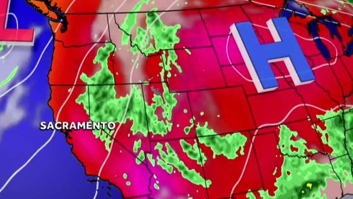
THE NEIGHBORS CONCERNS AND WE ARE WAITING FOR RESPONSE. IT IS NOW 418. TIME FOR ANOTHER CHECK ON OUR FORECAST AS WE TAKE A LIVE LOOK HERE AT A QUIET STOCKTON SKY CAMERA. LET’S GO TO METEOROLOGIST KELLY CURRAN. YEAH, WE’RE SEEING A LOT OF CLOUDY SKIES AND WARM TEMPERATURES THIS MORNING. BUT IF YOU’RE IN THE SIERRA, YOU’RE WAKING UP TO RAIN SHOWERS. NOW IN SACRAMENTO, IT IS CURRENTLY 73 DEGREES. WE’RE LOOKING AT WINDS OUT OF THE SOUTH AT JUST THREE MILES PER HOUR. BUT TAKE A LOOK AT THIS WIDER MAP HERE. AS YOU SEE ACTIVE WEATHER DOWN TO PARTS OF ARIZONA. AND THEN THIS LINE OF SHOWERS STREAMING FROM SOUTH TO NORTH THROUGH THE SIERRA. NOW LET’S ZOOM IN A LITTLE BIT CLOSER. AND YOU DO SEE SOME SHOWER ACTIVITY HERE DOWN NEAR SONORA. ARNOLD. YOU’VE BEEN SEEING A LITTLE BIT OF THAT ALREADY THIS MORNING AS WELL. ZOOMING IN EVEN CLOSER, YOU’RE SEEING THIS AREA OF YELLOW AND ORANGE THAT’S NEAR KIRKWOOD. THIS IS WHERE WE’RE SEEING SOME MODERATE RAIN SHOWERS NORTH OF THAT. IT’S MAINLY LIGHT SHOWER ACTIVITY THAT’S MOVING THROUGH SOUTH LAKE TAHOE AND TRUCKEE AND CONTINUING NORTHWARD FROM THERE. WE ALREADY HAVE PICKED UP SOME MEASURABLE RAINFALL IN THE SOUTH LAKE TAHOE REGION THIS MORNING. NOW TODAY IS GOING TO BE AN IMPACT DAY, NOT JUST TODAY, BUT TOMORROW AS WELL FOR THE SIERRA. WHAT ARE WE TALKING ABOUT HERE? WELL, POTENTIAL FOR BRIEF HEAVY DOWNPOURS, ESPECIALLY AS WE GET INTO THE AFTERNOON. DRY LIGHTNING POSSIBILITY. AND THAT OF COURSE COULD SPARK SOME FIRES. AND AS THE STORMS, ESPECIALLY THE COLLAPSING, WE MAY SEE SOME VERY GUSTY WINDS. SO MANY FIRES DO GET STARTED. THAT WOULD LEAD TO RAPID SPREAD. NOW LET’S TAKE A LOOK AT FUTURECAST AND HOW THIS IS EXPECTED TO PLAY OUT. AGAIN. FEW SHOWERS THIS MORNING, BUT CHANCES FOR THUNDERSTORMS LATER THIS AFTERNOON. THIS IS ALL MONSOON MOISTURE THAT’S MOVING A LITTLE BIT FURTHER TO THE WEST AND NORTH. AND WE TYPICALLY SEE TOMORROW MORE CHANCES FOR SHOWERS AND STORMS IN THE SIERRA, THOUGH I THINK THE BULK OF IT IS ACTUALLY GOING TO BE OVER INTO NEVADA AND ON THE EASTERN SLOPES OF THE SIERRA ON TUESDAY. BUT THIS IS SOMETHING THAT WE’RE GOING TO CONTINUE TO MONITOR WEDNESDAY. WE START TO DRY OUT. WE’LL SEE DRIER CONDITIONS AS WE HEAD THROUGHOUT THE REST OF THE WORKWEEK. BUT SHOWER CHANCES RETURNING TO THE SIERRA AS WE HEAD INTO NEXT WEEKEND. LET’S TAKE A LOOK AT THE SEVEN DAY FORECAST NOW I ALREADY MENTIONED FOR THE SIERRA. TODAY AND TOMORROW ARE IMPACT DAYS BECAUSE OF THE POTENTIAL FOR STORMS, BUT FOR THE FOOTHILLS, TUESDAY AND WEDNESDAY ARE ALSO GOING TO BE IMPACT DAYS. BUT THIS TIME IT’S BECAUSE OF THE HEAT. UPPER 90S AND IN THE VALLEY. ALSO LOOKING AT TUESDAY WEDNESDAY BEING IMPACT DAYS BECAUSE OF THE HEAT. BUT NOW WE’RE TALKING ABOUT TRIPLE DIGIT TEMPERATURES. SO WE HAVE A L
Northern California forecast: Increased fire risk due to thunderstorms, gusty winds

Updated: 6:55 AM PDT Jul 13, 2026
There is an increased chance of a fire sparking Monday in Northern California due to thunderstorms passing through the region.The KCRA 3 weather team is issuing an Impact Day for Monday because of that heightened risk. Meteorologist Kelly Curran said the storms, which are moving northward through the Foothills and Sierra, are capable of producing lightning and gusty winds. The storms could arrive by the afternoon.Storm chances could continue Tuesday, but it would mainly be on the eastern slopes of the Sierra.Curran said clouds could linger on and off throughout the day, with highs in the Valley reaching the mid-90s.Tuesday is expected to be an Impact Day for a broader region. More storms are expected for the Sierra, and triple-digit heat is likely for the Valley. Meanwhile, the Foothills could reach the upper 90s. Limited outdoor activity is recommended because of the heat, and people should stay hydrated to reduce the risk of heat-related illnesses.REAL-TIME TRAFFIC MAPClick here to see our interactive traffic map.TRACK INTERACTIVE, DOPPLER RADARClick here to see our interactive radar.DOWNLOAD OUR APP FOR THE LATESTHere is where you can download our app.Follow our KCRA weather team on social mediaMeteorologist Tamara Berg on Facebook and X.Meteorologist Dirk Verdoorn on FacebookMeteorologist/Climate Reporter Heather Waldman on Facebook and X.Meteorologist Kelly Curran on X.Meteorologist Ophelia Young on Facebook and X.Watch our forecasts on TV or onlineHere’s where to find our latest video forecast. You can also watch a livestream of our latest newscast here. The banner on our website turns red when we’re live.We’re also streaming on the Very Local app for Roku, Apple TV or Amazon Fire TV.See more coverage of top California stories here | Download our app | Subscribe to our morning newsletter | Find us on YouTube here and subscribe to our channel | Make KCRA a preferred news source in Google
There is an increased chance of a fire sparking Monday in Northern California due to thunderstorms passing through the region.
The KCRA 3 weather team is issuing an Impact Day for Monday because of that heightened risk.
Meteorologist Kelly Curran said the storms, which are moving northward through the Foothills and Sierra, are capable of producing lightning and gusty winds. The storms could arrive by the afternoon.
Storm chances could continue Tuesday, but it would mainly be on the eastern slopes of the Sierra.
Curran said clouds could linger on and off throughout the day, with highs in the Valley reaching the mid-90s.
Tuesday is expected to be an Impact Day for a broader region. More storms are expected for the Sierra, and triple-digit heat is likely for the Valley. Meanwhile, the Foothills could reach the upper 90s. Limited outdoor activity is recommended because of the heat, and people should stay hydrated to reduce the risk of heat-related illnesses.
REAL-TIME TRAFFIC MAP
Click here to see our interactive traffic map.
TRACK INTERACTIVE, DOPPLER RADAR
Click here to see our interactive radar.
DOWNLOAD OUR APP FOR THE LATEST
Here is where you can download our app.
Follow our KCRA weather team on social media
Meteorologist Tamara Berg on Facebook and X.Meteorologist Dirk Verdoorn on FacebookMeteorologist/Climate Reporter Heather Waldman on Facebook and X.Meteorologist Kelly Curran on X.Meteorologist Ophelia Young on Facebook and X.
Watch our forecasts on TV or online
Here’s where to find our latest video forecast. You can also watch a livestream of our latest newscast here. The banner on our website turns red when we’re live.
We’re also streaming on the Very Local app for Roku, Apple TV or Amazon Fire TV.
See more coverage of top California stories here | Download our app | Subscribe to our morning newsletter | Find us on YouTube here and subscribe to our channel | Make KCRA a preferred news source in Google