
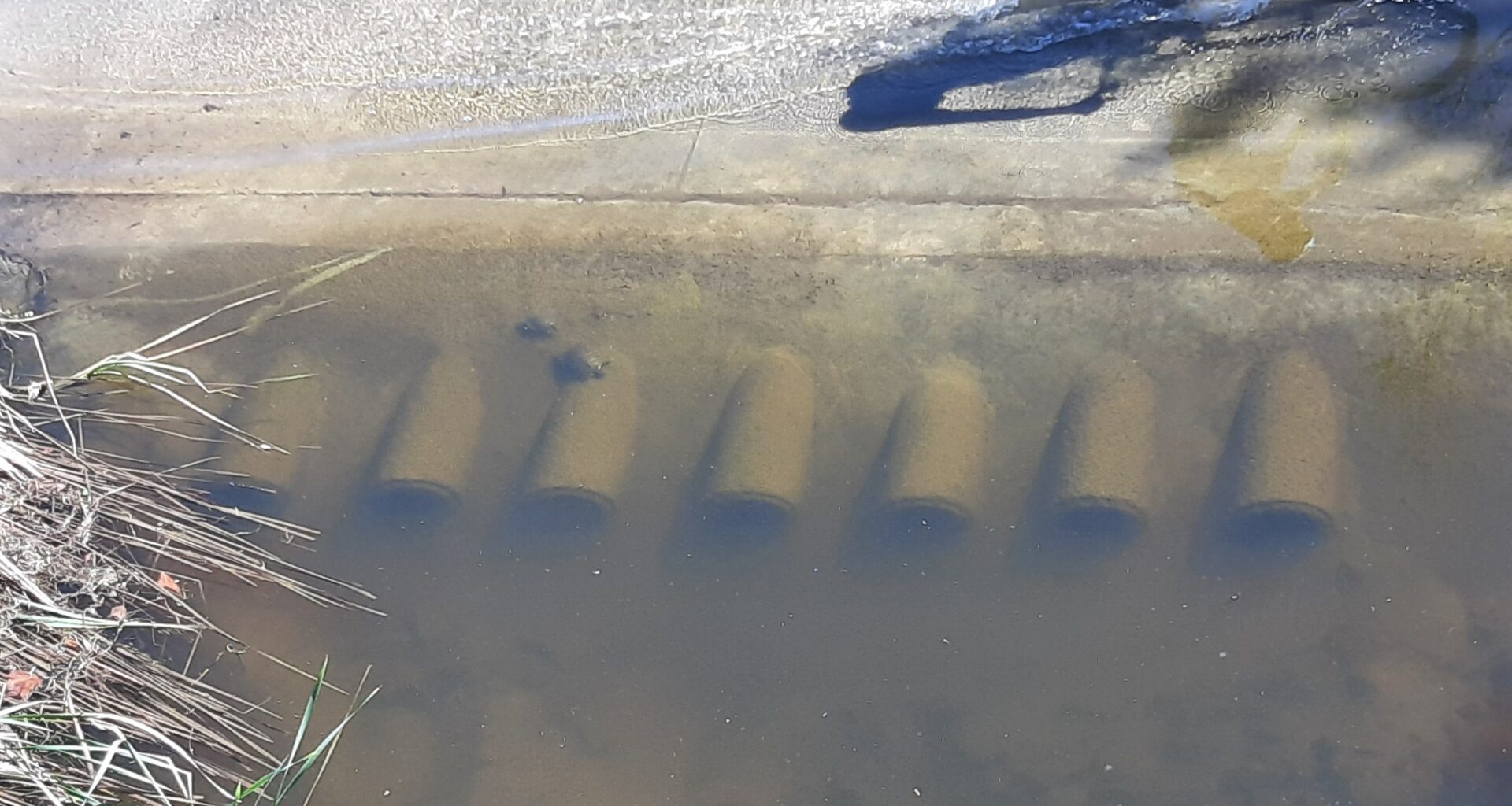
The Carmel Valley Community Planning Board unanimously approved a city plan to fix a frequently flooded spot on the SR-56 bike path, hoping to create a safer and drier ride for cyclists under the Carmel Country Road bridge. With its approval on July 23, the board additionally urged the city to make serious attempts to clean up the Carmel Valley Restoration Enhancement Project, the channel downstream that has become filled with dense vegetation over the years and may be contributing to the increase of water pooling under the bridge.
The city’s capital improvement project targets the low-flow channel crossing of Carmel Creek on the 56 bike path, where the trail dips under Carmel Country Road and comes out along a drainage pond before traveling along the edge of the Palacio Del Mar neighborhood. Following any kind of rain event, water often tops the trail, leaving it impassable and unsafe.
The city’s solution is to raise the bike path by two feet. The added elevation will allow for the construction of six new box culverts for the water to flow through below. Safety railings will be added on top of the raised crossing.
“This is an improved low flow crossing; it will be constructed at a higher elevation than the original structure but it will still be expected to flood during big storm events because it remains within a floodway,” said Kris Ekert, a senior civil engineer with the city’s stormwater department. “The design provides improved usability by reducing interruptions from minor rain events.”
Matt Bartelt, president of the San Diego Mountain Bike Association, expressed his support for the project on the widely used trail that serves as a critical component of the San Diego Regional Bike Network, connecting I-15 to the coast.
“The standing water under Carmel Country Road has been an issue for better than the last 10 years….it’s slippery and dangerous,” Bartelt said. “That part is inaccessible because of the water. Be it one inch or two feet, it is slippery and an exciting journey to say the least.”
He said while he understood that the project won’t cure all of the flooding problems, raising it by two feet will be an advantage.
At the planning board’s recommendation, the city met with the neighboring Palacio Del Mar Homeowners Association twice, including once in May and at another town hall on June 24 attended by about 40 people.
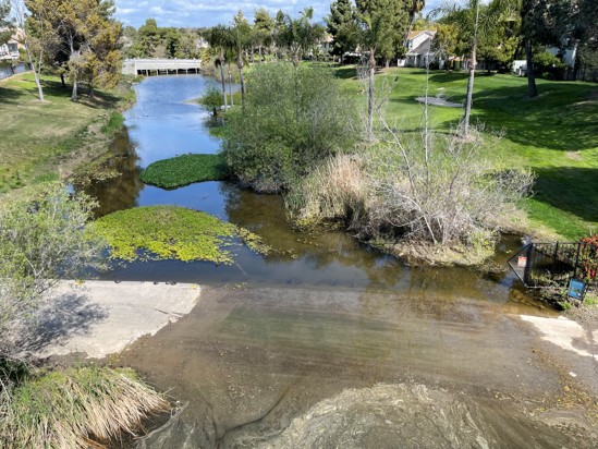 The flooded SR-56 bike path at Carmel Country Road. (Courtesy City of San Diego)
“While there were definitely differing opinions at this meeting, the discussion was overall productive and many attendees left with a better understanding of why the project is being proposed and how it balances transportation, environmental and design constraints,” said Anthony Salvani, an associate civil engineer
No one from the neighborhood was present at the board’s July 23 meeting to provide additional input.
Planning board Chair Michelle Strauss said she was appreciative of the city taking those extra steps, providing community outreach and raising public awareness of the project.
With the board’s vote of concurrence, the city will continue with the permitting process which includes permits from the California Coastal Commission, the California Department of Fish and Wildlife, Army Corps of Engineers, and the San Diego Regional Water Control Board. Construction is expected to begin in fall 2027 and be completed by fall 2028.
During the one-year construction, trail users will be detoured over the Carmel Country bridge and the board encouraged the city to ensure that the alternative route remains as safe as possible.
One of the board’s past concerns with the project was its high price tag. At the meeting, Ekert said they were able to reduce the cost from $3.7 million to $2.7 million after taking a closer look and discovering some misplacements of items in the cost estimate. A total of $8 million in developer impact fees is allocated to the project in the city’s budget.
With his motion to approve the project, board member Adam Fox said it gave him pause that the cost refinements were made only after they “scoffed” at the cost.
“On the one hand that’s great that you found a million dollars, on the other hand it’s scary that we told you to sharpen your pencils and you found a million,” said Fox. “I would love to see this project get done as efficiently as possible. I think that the bike safety is important, there are a lot of bikers that use that trail and it’s money that should be invested in this community.”
According to the city, the project’s goal is to improve trail safety for users while minimizing impacts to surrounding habitat, where they face significant environmental constraints that prevent them from clearing or dredging the overgrowth downstream.
The area known as the Carmel Valley Restoration Enhancement Project (CVREP) was established as mitigation for building SR-56 and it is meant to be a dense riparian habitat, capturing sediment before it discharges into the Los Penasquitos Lagoon.
“It functions as a protected wetland and riparian habitat corridor regulated by environmental agencies,” Salvani said. “Because of its environmental protection, large-scale modifications are generally not feasible.”
“The project doubles as a floodwater and a multi-habitat planning area so that is what makes it pretty much a no-touch as far as doing maintenance in the channel,” Ekert added.
Carmel Valley resident Kevin Hainley has long been opposed to this project, pointing to a larger issue of mismanagement and neglect by the city.
“Over an extended period of time, the apparent lack of managing the floodplain and restoration project has turned Carmel Creek into less of a low flow and more of a no flow,” stated a letter by Hainley, read into the record at the meeting by his wife Holly.
For many years, he said the existing seven drain pipes (now submerged) effectively managed the low-flow channel. Now as the channel has become increasingly clogged, the water builds up. The result, he said, is “foul-smelling” stagnant water that has become home to invasive red slider turtles: “This is not a natural body of water to protect, it is the result of human actions or lack of human action,” his letter stated. “The proposed solution solves nothing.”
While he supported the project, board member Kevin Jasper agreed that the standing water seems like it will continue to be a problem unless the city fixes the conditions downstream.
During the group’s discussion, board member Debbie Lokanc referenced the work that the stormwater department has done to clear the Chollas Creek channel in San Diego following the February 2024 flooding that damaged homes and displaced residents. Thousands of residents have filed lawsuits against the city alleging that it caused the flooding by failing to maintain its stormwater system—this year the city agreed to pay more than $6 million to a group of insurance companies that paid out property owners’ claims.
A $11 million creek restoration project is now underway, funded by the California Natural Resources Agency, the California Wildlife Conservation Board, and the Integrated Regional Water Program.
As the city has stated, the Carmel Creek project is mainly focused on solving the bike path issue. The city said that while environmental mitigation impacts and costs to work downstream are very restrictive, the project will include mitigation efforts to address the impacts of non-native plant species and to remove sediment within the project footprint.
In response to concerns raised by local residents and the planning board, Eckert said the city is open to exploring separate projects to address habitat management and improvements in the CVREP.