
Hurricane Genevieve remains a powerful major hurricane in the eastern Pacific on Tuesday, even as forecasters said the storm is expected to gradually weaken in the coming days.
Genevieve underwent a period of rapid intensification over exceptionally warm Pacific waters, briefly reaching Category 5 strength before weakening slightly. The hurricane became the strongest storm of the eastern Pacific season so far. While the hurricane is forecast to stay well offshore and poses no direct threat to California, meteorologists are warning that large swells generated by the storm could create dangerous beach conditions along parts of the West Coast.
“We are very concerned about increased surf,” AccuWeather Lead Hurricane Expert Alex DaSilva told Newsweek. “Anywhere across Western Mexico all the way up to Southern California.”
Read More on Weather
California is already starting to see increased surf caused by the storm, DaSilva said, which will continue throughout the rest of the week alongside dangerous rip currents.
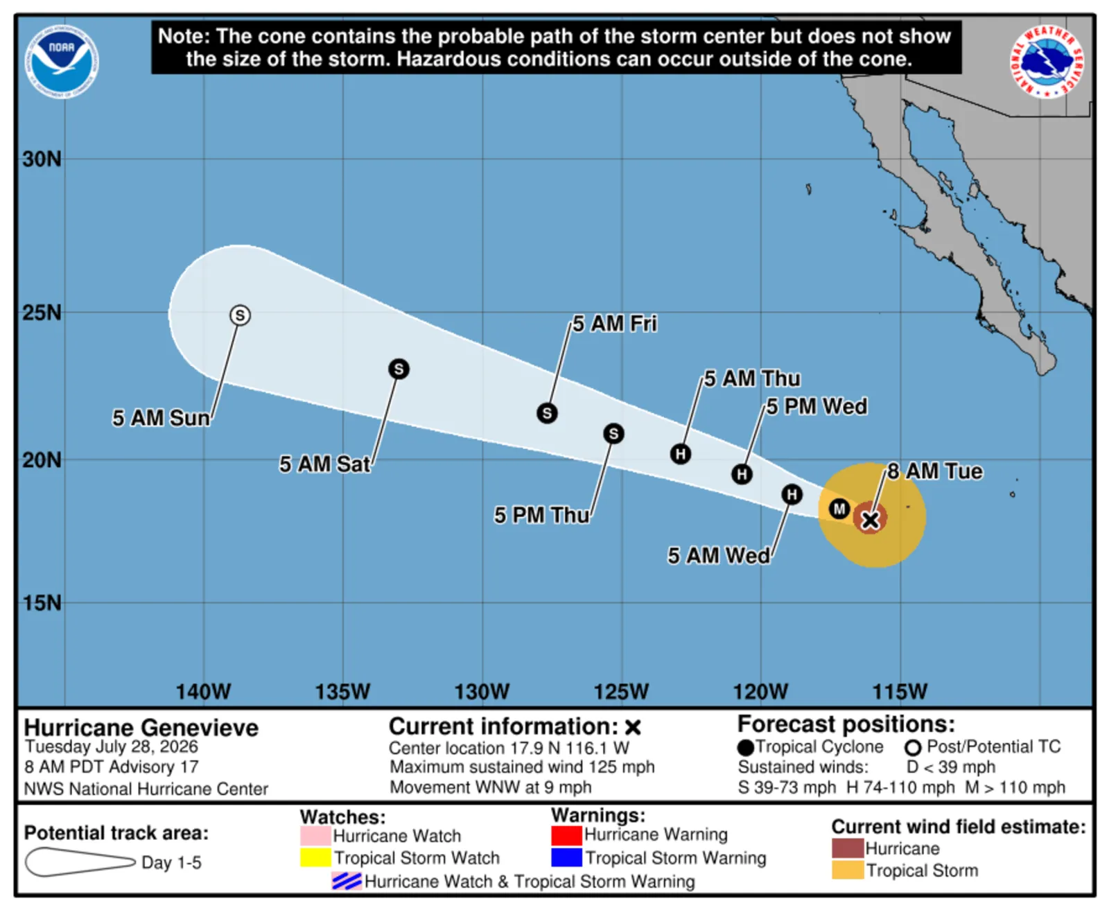
The National Hurricane Center (NHC) said early Tuesday that Genevieve was located about 530 miles southwest of the southern tip of Baja California, with maximum sustained winds of 125 miles per hour, making it a high-end Category 3 hurricane on the Saffir-Simpson Hurricane Wind Scale. The storm was moving west-northwest around 9 mph and is expected to continue tracking over open waters. Forecasters said a gradual weakening trend is anticipated during the next several days as Genevieve moves over cooler ocean temperatures.
 Hurricane Genevieve to Impact U.S. West Coast
Despite remaining far from the U.S. coastline, Genevieve’s powerful wind field is generating long-period swells that are traveling hundreds of miles across the Pacific. The NHC has warned that those swells are already affecting parts of Mexico and the Baja California Peninsula, producing potentially life-threatening surf and rip current conditions. In a report published on Monday, AccuWeather warned that the life-threatening swells could “pose dangers” to small craft and swimmers in California, as well.
“While eastern Pacific Major Hurricane Genevieve poses no direct threat to land, it has become the most powerful hurricane in the waters surrounding North and Central America this year and the first Category 5 hurricane since Kristy in 2024,” DaSilva said in the report.
California beaches that face south and southwest are expected to experience the increased surf, with the largest waves forecast around Thursday and into the weekend.
The National Weather Service (NWS) has issued advisories for portions of the Southern California coast, citing the risk of dangerous swimming conditions, strong rip currents and elevated surf. Forecasters say even experienced beachgoers should exercise caution, as long-period swells can create deceptively powerful waves and sudden surges of water near jetties, rocks and shorelines.
Coastal flooding could also become an issue in Southern California.
“High tides of 6.2 to near 7.0 feet will occur in the evening hours through Friday night, peaking tonight through Thursday night,” NWS Los Angeles said in an advisory. “In conjunction with the highest expected surf from the Hurricane Genevieve southerly swell, the best potential for minor coastal flooding impacts is expected Wednesday and Thursday evening.”
Hurricane Genevieve Live Tracker Maps
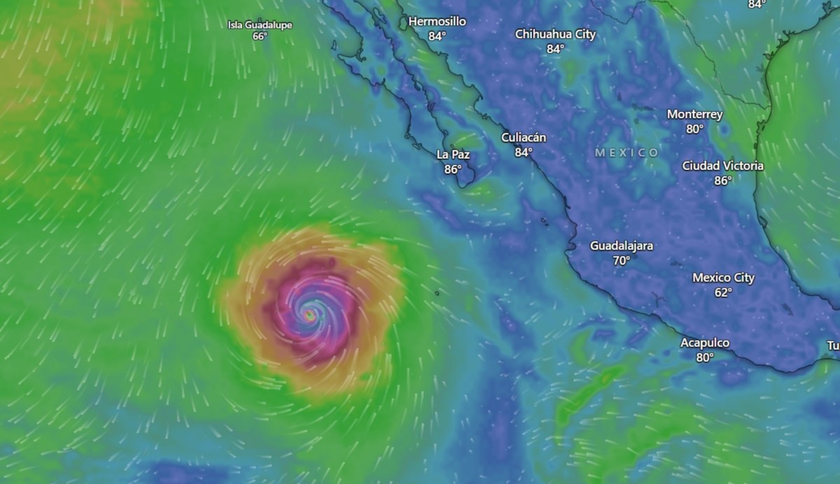
Animated weather footage from windy.com showed Genevieve churning over the Eastern Pacific with strong winds. However, near land, the winds were much calmer.
Heavy rain was also accompanying the storm but is expected to remain over the open waters of the Pacific. Windy.com footage revealed that as much as 11 inches of rain could fall near the storm over the next three days, although the heavy rainfall is not expected to impact land.
Large waves and dangerous currents are expected to impact land, though, and as of late Tuesday morning, Windy.com showed waves of around 9 feet near the southern tip of Baja California.
How El Niño Affects Hurricane Season
While El Niño can suppress hurricane activity in the Atlantic basin during the hurricane season, the climate pattern can make the Pacific hurricane season significantly more active by creating atmospheric conditions that are more favorable for tropical cyclone development.
Forecasters say El Niño typically reduces vertical wind shear—the changes in wind speed and direction that can disrupt developing storms—across the eastern and central Pacific. At the same time, warmer-than-average ocean waters provide additional energy for tropical systems, allowing more storms to form and increasing the likelihood that some will intensify into major hurricanes.
That combination can lead to more named storms, stronger hurricanes and a greater risk of rapid intensification. As El Niño strengthens this summer, forecasters often look for above-average activity in the Pacific basin, even as hurricane activity in the Atlantic may be suppressed by the same climate pattern. Experts have warned that the developing 2026 El Niño could help fuel an unusually active eastern Pacific season by reducing disruptive wind shear and maintaining favorable oceanic conditions for storm growth.
What Happens Next
For now, forecast models keep Genevieve over open water with no indication of a direct landfall. By Wednesday morning, the NHC anticipates Genevieve will fall below major hurricane strength. It will continue to weaken until it is once again a tropical storm by Thursday evening.
Even so, weather officials stress that Californians should monitor local beach forecasts through the week, as dangerous surf and rip currents can occur even when a hurricane is hundreds of miles away.
In addition to Hurricane Genevieve, the NHC is also tracking Tropical Storm Fausto, which is taking aim at Hawaii.
Contact Newsweek editors on this story: Jason Lemon and Sam Wilson.