
It has been an extraordinarily warm in recent days across California, with high temperatures reaching 100 degrees Wednesday and Thursday not only in the Central Valley, but in portions of the Bay Area and around Los Angeles as well.
The warm stretch comes to a close Friday, and this weekend temperatures will even dip into below-average territory across much of the region as lower pressure air rushes in.
While this might seem fantastic for your weekend plans, note that this rush will come with wind — and that wind could be a problem on its own.

Lower atmospheric pressure across the Pacific coast will allow cooler temperatures to rush in suddenly between Friday and Saturday.
Winds will pose a fire risk, especially Saturday
In the upper atmosphere, a trough of lower pressure will settle across the Pacific coast of the United States on Friday and Saturday, quickly ushering in strong onshore winds and cooler temperatures.
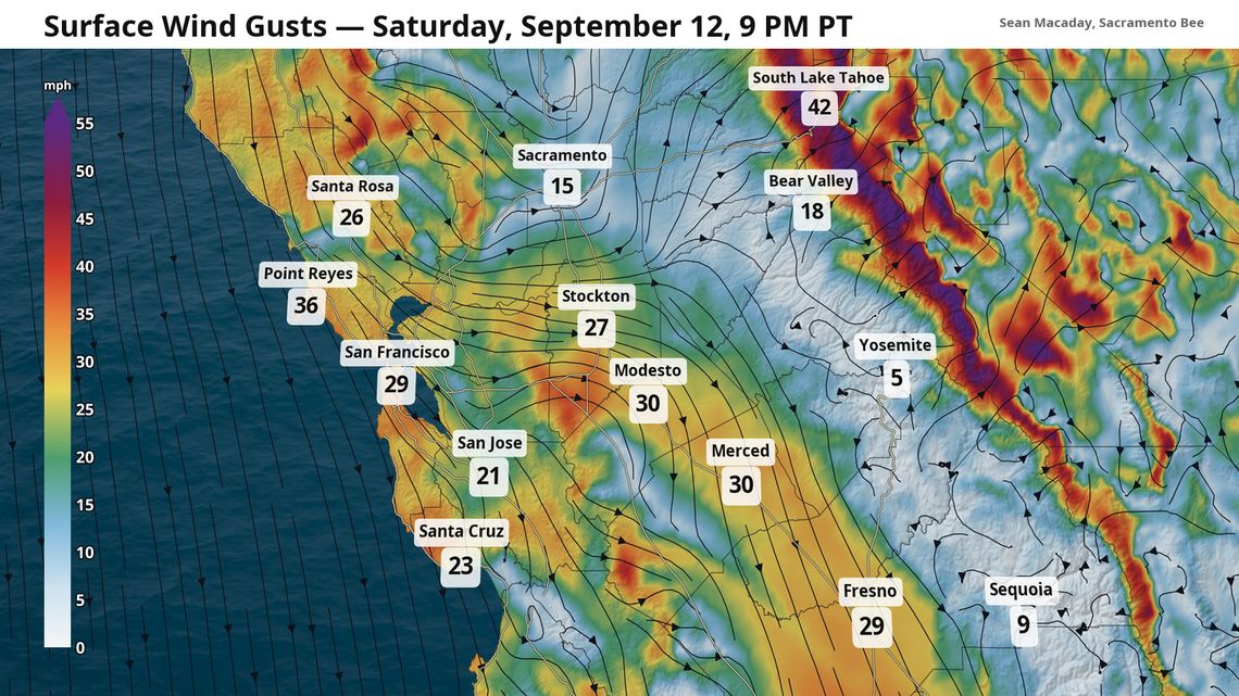
On the wind side, winds out of the northwest will rush in across Northern and Central California, gusting up to 20 mph Friday afternoon and up to 30 mph Saturday afternoon and evening. Winds near Fresno and Merced could gust up to 25 mph Saturday afternoon, with higher speeds in open areas.
For the San Joaquin Valley, fire risk will still be elevated during this stretch. Watch for any updates through the weekend as conditions continue to draw closer.
The winds become more severe at elevation, where the contraction of the atmosphere along ridgelines and mountain peaks could exceed 40-50 mph in parts of the Sierra. A series of high wind watches and wind advisories are out along the California-Nevada border near Reno for Saturday. Gusts on Lake Tahoe could exceed 40 mph, posing a serious issue for boaters.

A fire weather watch has been issued for the Sacramento Valley north of Sacramento for Saturday.

Heavy soaking rains across the mountainous regions of Northern California last week have reduced the risk for wildfire. Data does not include recent rains in far Southern California.
Meanwhile, this sudden breeze will exacerbate the risk for spreading fires, particularly for the Sacramento Valley to the north. A fire weather watch — issued before a Red Flag Warning — is out for the Sacramento Valley north of Sacramento Saturday afternoon, alongside much of the basin-side of the Sierra through Monday morning. Strong winds and rather arid conditions will mix to create nasty conditions for any fires that do start.
In far Northern California, soaking rains from last week will greatly help alleviate this risk. Soil moisture levels are now running above average across much of this region in the mountains, although fires are still possible.
Winds will begin to calm Sunday as the stream out of the northwest becomes more steady.
Cool down arrives for good this weekend

Temperatures will continue to cool through Sunday day after day.
For the San Joaquin Valley, high temperatures will still flirt with or reach triple digits Friday, but will themselves tumble into the 80s by Sunday. Even Fresno will only peak in the mid-80s Sunday, a massive departure from 105 degrees on Thursday.
And as the trough of lower pressure equalizes with the rest of the atmosphere next week, temps will only warm slightly. Several days of highs in the upper 80s and low 90s are expected throughout the Central Valley for the middle of September.