
VISIBILITY AT FOUR MILES RIGHT NOW. TEMPERATURES TODAY WE’RE HEADING UP UPPER 70S EXPECTED WITH JUST MOSTLY SUNNY SKIES AFTER THE FOG FADES AND A LIGHT NORTH BREEZE, WE GET INTO THE AFTERNOON IN THE FOOTHILLS. BEAUTIFUL DAY SETTING UP SHOP WITH MID 70S AHEAD AND TODAY FOR THE SIERRA PLANNER. EXPECT THOSE DAYTIME HIGHS TO PUSH INTO MID TO UPPER 60S WITH A LIGHT SUBTLE SOUTHWEST BREEZE, SUN AND CLOUDS MIXING IN. NOW AS WE GET INTO THE DAY ON TUESDAY. TUESDAY EXPECTED TO BE A DRY DAY WITH PARTLY CLOUDY SKIES. GREAT NEWS FOR ALL OF THOSE OUTDOOR OBSERVANCES IN HONOR OF VETERANS DAY. NOW WE GET INTO WEDNESDAY AND YOU’LL NOTICE THAT WE HAVE JUST MORE CLOUD COVER INCREASING. I THINK DAYLIGHT HOURS WEDNESDAY ARE GOING TO BE DRY, BUT THEN YOU SEE THIS BIG AREA OF MOISTURE THAT PUSHES ONSHORE OVERNIGHT WEDNESDAY INTO THE EARLY PARTS OF THURSDAY. NOW THURSDAY, LOOKING LIKE THE WETTEST PART OF THIS WEEK. AND YOU’LL NOTICE SOME HIGH ELEVATION SNOWFALL PRIMARILY DURING THE DAY THURSDAY ABOVE 8000FT. AND THEN AS THAT SYSTEM, THE COOLER CORE MOVES ONSHORE, EXPECT, WE WILL SEE THAT SNOW LEVEL LOWERS TO AROUND 6000FT AND THE RAIN SHOWERS WITH THIS SYSTEM KIND OF SIMILAR TO WHAT WE SAW LAST WEEK WITH OUR STORM VALLEY SPOTS, COULD PICK UP BETWEEN ABOUT A HALF AN INCH TO AN INCH IN THE FOOTHILLS, AN INCH PLUS EXPECTED. AND AGAIN, THOSE SNOW LEVELS STARTING OUT AROUND 8000, DROPPING DOWN TO AROUND 6000. AND THAT WILL INCLUDE LAKE LEVEL WITH STEADIER SOUTHWEST WINDS GUSTING IN THE VALLEY 30 TO 40MPH. THIS IS ALL HIGHLIGHTED FOR YOU AND STRESSED IN THE SEVEN DAY FORECAST. NICE STRETCH OF WEATHER CONTINUES WITH MILD TEMPERATURES THROUGH AT LEAST WEDNESDAY AND THEN THURSDAY IT IS GAME ON. WE’VE GOT A WET AND WINDY DAY PRETTY MUCH SETTING UP WITH TEMPERATURES AND HIGHS ONLY IN THE LOW 60S. WE DROP IT BACK WITH THE COOLER AIR ON FRIDAY WITH HIGHS IN THE UPPER 50S, AND MAYBE A FEW LEFTOVER SHOWERS. THEN THE WEEKEND. AT THIS POINT WE’VE LEFT DRY, BUT KEEP IN MIND THAT IS SUBJECT TO CHANGE. BUT WE’RE REALLY EYEBALLING THURSDAY FOR THE WETTEST PART OF THE WEEK. ALL RIGHT, ALL RIGHT. GOOD SNOW BRIAN. THE SNOW LOOKS GOOD. ALL RIGHT. YEAH
Northern California forecast: What we know about rain, wind and snow this week
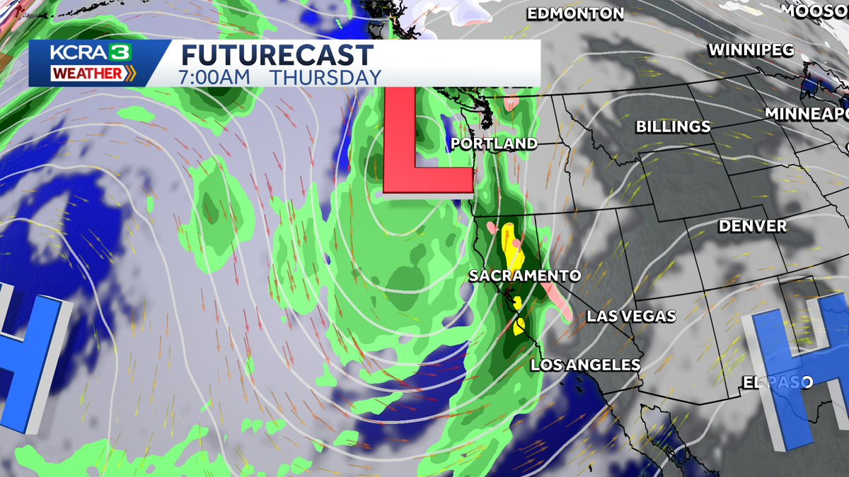
KCRA 3’s weather team is calling Thursday an Impact Day because of the forecast for rain, wind and snow.

Updated: 6:23 AM PST Nov 10, 2025
Comfortable weather begins the week in Northern California, but changes are on the way. Clouds increase and temperatures will dip on Wednesday, with drizzle to light showers and breezy conditions developing by the late evening. KCRA 3’s weather team is calling Thursday an Impact Day because of the forecast for rain, wind and snow. Current forecast data suggest moderate to heavy rain will move through the region overnight into Thursday morning, changing to snow in the Sierra above 8,000 feet. Snow levels will gradually drop to around 6,000 feet as showers persist through the first half of Friday. Thunder and lightning are possible. Valley rain totals are expected to range from half an inch to an inch. The Foothills could get more than an inch of rain. Wind gusts in the Valley could range from 30-40 mph. We will continue to fine-tune the details as we get them. REAL-TIME TRAFFIC MAPClick here to see our interactive traffic map.TRACK INTERACTIVE, DOPPLER RADARClick here to see our interactive radar.DOWNLOAD OUR APP FOR THE LATESTHere is where you can download our app.Follow our KCRA weather team on social mediaMeteorologist Tamara Berg on Facebook and X.Meteorologist Dirk Verdoorn on FacebookMeteorologist Heather Waldman on Facebook and X.Meteorologist Kelly Curran on X.Meteorologist Ophelia Young on Facebook and X.Watch our forecasts on TV or onlineHere’s where to find our latest video forecast. You can also watch a livestream of our latest newscast here. The banner on our website turns red when we’re live.We’re also streaming on the Very Local app for Roku, Apple TV or Amazon Fire TV.See more coverage of top California stories here | Download our app | Subscribe to our morning newsletter | Find us on YouTube here and subscribe to our channel–KCRA3’s Daniel Macht contributed to this report.
Comfortable weather begins the week in Northern California, but changes are on the way.
Clouds increase and temperatures will dip on Wednesday, with drizzle to light showers and breezy conditions developing by the late evening.
KCRA 3’s weather team is calling Thursday an Impact Day because of the forecast for rain, wind and snow.
Current forecast data suggest moderate to heavy rain will move through the region overnight into Thursday morning, changing to snow in the Sierra above 8,000 feet. Snow levels will gradually drop to around 6,000 feet as showers persist through the first half of Friday. Thunder and lightning are possible.
Valley rain totals are expected to range from half an inch to an inch. The Foothills could get more than an inch of rain.
Wind gusts in the Valley could range from 30-40 mph.

We will continue to fine-tune the details as we get them.
REAL-TIME TRAFFIC MAP
Click here to see our interactive traffic map.
TRACK INTERACTIVE, DOPPLER RADAR
Click here to see our interactive radar.
DOWNLOAD OUR APP FOR THE LATEST
Here is where you can download our app.
Follow our KCRA weather team on social media
Meteorologist Tamara Berg on Facebook and X.Meteorologist Dirk Verdoorn on FacebookMeteorologist Heather Waldman on Facebook and X.Meteorologist Kelly Curran on X.Meteorologist Ophelia Young on Facebook and X.
Watch our forecasts on TV or online
Here’s where to find our latest video forecast. You can also watch a livestream of our latest newscast here. The banner on our website turns red when we’re live.
We’re also streaming on the Very Local app for Roku, Apple TV or Amazon Fire TV.
See more coverage of top California stories here | Download our app | Subscribe to our morning newsletter | Find us on YouTube here and subscribe to our channel
–KCRA3’s Daniel Macht contributed to this report.