
More rain, wind and snow: What you need to know for Northern California Impact Day on Thursday
Rain, wind, and Sierra snow move into the region Wednesday night, but the heaviest precipitation is forecast for Thursday.
SATELLITE IMAGERY CERTAINLY SHOWING QUITE A FEW CLOUDS, MOST OF THEM HIGH CLOUDS, THOUGH MOVING THEIR WAY FROM WEST TO EAST THROUGH THE REGION, BUT NO PRECIPITATION. AND THAT’S THE WAY IT’S GOING TO STAY TODAY. SO WE’LL SEE A FEW CLOUDS ON AND OFF TEMPERATURES, THOUGH THE WARMEST WE’RE GOING TO SEE ALL WEEK, IN FACT, ABOUT TEN DEGREES ABOVE NORMAL. NOW, AS WE GET INTO TOMORROW, TEMPERATURES DIP A LITTLE BIT. A FEW MORE CLOUDS, BUT STILL A DRY AND MILD DAY FOR VETERAN’S DAY. WEDNESDAY, THOUGH, EVEN THICKER CLOUDS. THE TEMPERATURES DIP EVEN FURTHER BY THE TIME WE GET INTO THE AFTERNOON AND EVENING, WE MAY START TO SEE A LITTLE BIT OF DRIZZLE AND MIST, ESPECIALLY AS YOU GET CLOSER TO THE COAST. BUT THURSDAY, THAT’S THE IMPACT DAY AS THIS TROUGH OF LOW PRESSURE SWINGS ITS WAY THROUGH. YOU’LL SEE SOME OF THE HEAVIEST RAIN, I THINK, IN THE VALLEY DURING THE MORNING HOURS. SOMETHING TO KEEP IN MIND FOR THAT MORNING COMMUTE AND THE SNOW LEVELS DROPPING IN. THE SIERRA COULD SEE SOME PRETTY SIGNIFICANT SNOWFALL OUT OF THIS ONE. AS WE HEAD THROUGH THURSDAY NIGHT. NOW, FRIDAY, THERE’S A POSSIBILITY FOR A FEW LINGERING SHOWERS AROUND, BUT SATURDAY EVERYTHING STARTS TO DRY BACK OUT. A WEAKER SYSTEM STARTS TO MOVE ITS WAY IN ON MONDAY OR SUNDAY INTO MONDAY, BRINGING US POTENTIALLY ANOTHER ROUND OF RAIN AND SNOW INTO THE REGION. THEN HIGH PRESSURE STARTS TO BUILD IN TOWARD THE MIDDLE OF THE WEEK. SO LET’S TALK ABOUT HOW MUCH RAIN WE MIGHT SEE OUT OF THIS SYSTEM. SO FOR YUBA CITY AND SACRAMENTO, UP TO AN INCH. BLUE CANYON UP TO THREE INCHES. TRUCKEE COULD SEE UP TO AN INCH. AND THEN OF COURSE, NOW WE’VE GOT TO TALK ABOUT THE SNOW TOTALS. AND THESE ARE LOOKING PRETTY IMPRESSIVE. IN FACT, DONNER SUMMIT COULD SEE UP TO 12IN EBBETTS PASS UP TO 24IN AND SONORA PASS UP TO 26. CERTAINLY GREAT NEWS THOUGH, FOR THE SKI RESORTS THAT ARE GETTING READY TO OPEN. LET’S TAKE A LOOK AT THOSE SEVEN DAY FORECAST. SO TODAY 78 DEGREES, MOSTLY SUNNY. BUT LOOK AT THE CHANGE. THURSDAY’S HIGH 60 WITH THE RAIN AND THE WIND. FRIDAY. 58. SO WE’RE TALKING ABOUT A 20 DEGREE DROP IN TEMPERATURES BETWEEN MONDAY AND FRIDAY. WOW.
More rain, wind and snow: What you need to know for Northern California Impact Day on Thursday
Rain, wind, and Sierra snow move into the region Wednesday night, but the heaviest precipitation is forecast for Thursday.

Updated: 10:39 AM PST Nov 10, 2025
The workweek is starting out pleasant with temperatures nearly 10 degrees above normal, but big changes begin by midweek. Clouds increase and temperatures dip on Wednesday, with drizzle and light showers along with breezy conditions developing by the late evening. Light rain may start along the coast and in the coastal ranges Wednesday afternoon. KCRA 3’s weather team is calling Thursday an Impact Day because of the forecast for rain, wind and snow.Current forecast data suggest moderate to heavy rain will move through the region overnight into Thursday morning, creating a messy morning commute. Rain changes to snow in the Sierra above 8,000 feet, but snow levels gradually drop to around 6,000 feet as showers persist into Friday. Thunder and lightning are also possible.Valley rain totals are expected to range from half an inch to an inch and half with the highest amounts along and North of I-80. The Foothills could receive up to 3 inches of rainfall from this system. Snowfall totals will be significant with close to a foot of snow possible in the passes along I-80 and Highway 50. Ebbett’s Pass and Sonora Pass could see 2 feet of snow by Friday morning. Wind gusts in the Valley could range from 30-40 mph.REAL-TIME TRAFFIC MAPClick here to see our interactive traffic map.TRACK INTERACTIVE, DOPPLER RADARClick here to see our interactive radar.DOWNLOAD OUR APP FOR THE LATESTHere is where you can download our app.Follow our KCRA weather team on social mediaMeteorologist Tamara Berg on Facebook and X.Meteorologist Dirk Verdoorn on FacebookMeteorologist Heather Waldman on Facebook and X.Meteorologist Kelly Curran on X.Meteorologist Ophelia Young on Facebook and X.Watch our forecasts on TV or onlineHere’s where to find our latest video forecast. You can also watch a livestream of our latest newscast here. The banner on our website turns red when we’re live.We’re also streaming on the Very Local app for Roku, Apple TV or Amazon Fire TV.See more coverage of top California stories here | Download our app | Subscribe to our morning newsletter | Find us on YouTube here and subscribe to our channel
SACRAMENTO, Calif. —
The workweek is starting out pleasant with temperatures nearly 10 degrees above normal, but big changes begin by midweek.
Clouds increase and temperatures dip on Wednesday, with drizzle and light showers along with breezy conditions developing by the late evening. Light rain may start along the coast and in the coastal ranges Wednesday afternoon.
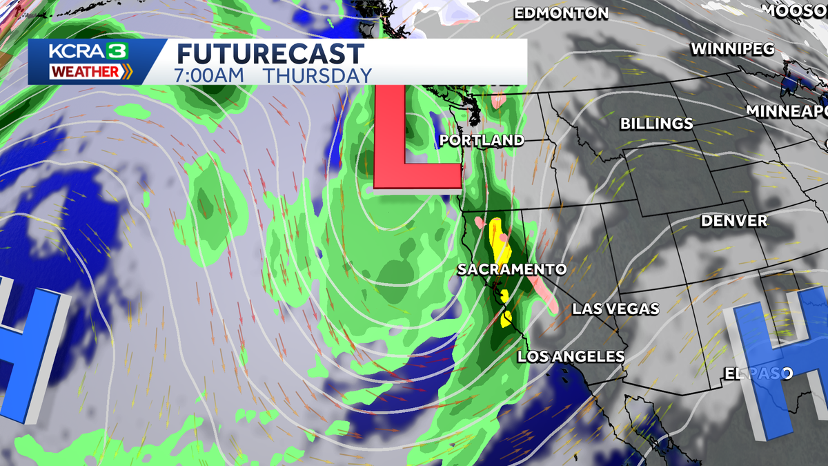
KCRA 3’s weather team is calling Thursday an Impact Day because of the forecast for rain, wind and snow.
Current forecast data suggest moderate to heavy rain will move through the region overnight into Thursday morning, creating a messy morning commute. Rain changes to snow in the Sierra above 8,000 feet, but snow levels gradually drop to around 6,000 feet as showers persist into Friday. Thunder and lightning are also possible.
Valley rain totals are expected to range from half an inch to an inch and half with the highest amounts along and North of I-80. The Foothills could receive up to 3 inches of rainfall from this system.

KCRA 3
Estimated rainfall totals Thursday November 13, 2025
Snowfall totals will be significant with close to a foot of snow possible in the passes along I-80 and Highway 50. Ebbett’s Pass and Sonora Pass could see 2 feet of snow by Friday morning.

KCRA 3
Estimated snowfall totals November 13-14th, 2025
Wind gusts in the Valley could range from 30-40 mph.
REAL-TIME TRAFFIC MAP
Click here to see our interactive traffic map.
TRACK INTERACTIVE, DOPPLER RADAR
Click here to see our interactive radar.
DOWNLOAD OUR APP FOR THE LATEST
Here is where you can download our app.
Follow our KCRA weather team on social media
Meteorologist Tamara Berg on Facebook and X.Meteorologist Dirk Verdoorn on FacebookMeteorologist Heather Waldman on Facebook and X.Meteorologist Kelly Curran on X.Meteorologist Ophelia Young on Facebook and X.
Watch our forecasts on TV or online
Here’s where to find our latest video forecast. You can also watch a livestream of our latest newscast here. The banner on our website turns red when we’re live.
We’re also streaming on the Very Local app for Roku, Apple TV or Amazon Fire TV.
See more coverage of top California stories here | Download our app | Subscribe to our morning newsletter | Find us on YouTube here and subscribe to our channel