
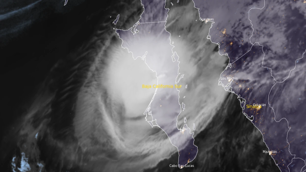
At landfall, Polo’s center was located approximately 130 km (80 miles) north of Cabo San Lázaro and 115 km (70 miles) south of Mulegé. The hurricane was moving northeast at 20 km/h (13 mph), with a minimum central pressure of 965 hPa.
Hurricane-force winds extended up to 65 km (40 miles) from the center, while tropical-storm-force winds extended up to 165 km (105 miles).
Hurricane Warnings remained in effect along the west coast of Baja California Sur from Punta Abreojos to Santa Fe, along the east coast from Loreto to Bahía San Juan Bautista and on mainland Mexico from Bahía Kino to Huatabampito.
Video credit: NOAA/OES-19/NHC
Hurricane Watches and Tropical Storm Warnings covered adjacent sections of Baja California Sur and the mainland coast from south of Huatabampito to Topolobampo. NHC said hurricane conditions would continue across the peninsula for several hours before reaching northwestern mainland Mexico early on September 29.
Polo is forecast to produce 150–305 mm (6–12 inches) of rain across parts of Baja California Sur. Southern and central Sonora could receive 100–150 mm (4–6 inches), with local totals reaching 200 mm (8 inches).
NHC warned that the rainfall could produce life-threatening flooding and mudslides, particularly in steep terrain.
Satellite loop of Hurricane Polo making landfall over Baja California Sur on September 29, 2026. Credit: NOAA/OES-19/NHC
Storm surge was expected to cause significant coastal flooding in areas exposed to onshore winds. Large and destructive waves, dangerous surf and rip currents were also forecast along the Baja California Peninsula and northwestern Mexico.
Ahead of landfall, high tides and pounding waves were breaching sea barriers and flooding some streets in Puerto San Carlos. Hundreds of people in the surrounding region had moved into shelters.
In López Mateos, intense rainfall caused a significant electrical failure at the community’s main well, interrupting potable-water service. The Comondú municipal water authority said the system could not be restarted immediately and that service would be restored when weather conditions allowed repairs.
Baja California Sur officials inspected temporary shelters in San Juanico, Las Barrancas and La Poza Grande before landfall. Residents in exposed areas were urged to follow Civil Protection instructions and move to shelters when directed.
NHC expected Polo to weaken while crossing Baja California Sur but remain a hurricane when it reached southern Sonora on the morning of September 29. Rapid weakening was forecast after the second landfall as the circulation moved over the rugged terrain of northwestern Mexico.
Video credit: NOAA/OES-19/NHC
An amplifying mid- to upper-level trough over the southwestern United States was steering Polo northeastward. NHC said the cyclone’s remnants could interact with a cutoff low and contribute to heavy rainfall, flash flooding and gusty winds across the southwestern United States and Southern High Plains on September 29 and 30.
A Wind Advisory was in effect for parts of southern New Mexico and far western Texas, where strong gusts associated with Polo’s remnants were possible late September 29 and during the following night.
References:
1 Hurricane Polo Intermediate Advisory Number 34A – NOAA/NHC – September 29, 2026
2 Hurricane Polo Discussion Number 34 – NOAA/NHC – September 29, 2026
3 Water-well failure in López Mateos following heavy rainfall – Municipality of Comondú / OOSAPAS – September 28, 2026