
Northern California forecast: Clouds increase today and showers arrive tonight
Wednesday will be dry to start and clouds will drop highs a bit from yesterday.
SCAM. IT IS NOW. 548. WE TURN OUR ATTENTION TO THE FORECAST. NOW, TAMARA, AND GET ANYTHING YOU NEED DONE OUTSIDE NOW OR IN THE NEXT, YOU KNOW, SEVERAL HOURS BECAUSE TONIGHT, DIFFERENT STORY. IF YOU’RE A PROCRASTINATOR LIKE I AM, YOU’RE RUNNING AROUND TODAY AND GETTING THINGS ORGANIZED AND READY FOR THIS INCOMING STORM BECAUSE IT IS GOING TO BE A DOOZY. IT’S GOING TO BE A LITTLE STRONGER THAN THE ONE WE HAD LAST WEEK, AND IT’S GOING TO BRING MORE RAIN AND PERIODS OF GUSTY WINDS INTO NORTHERN CALIFORNIA AS EARLY AS THIS TIME TOMORROW MORNING. LIVE. LOOK OUTSIDE HERE FROM SUTTER HEALTH BALLPARK. GOOD MORNING, YOLO COUNTY AND SACRAMENTO COUNTY. YOU’RE WAKING UP WITH JUST SOME PASSING CLOUDS. TEMPERATURES RIGHT NOW IN THE SACRAMENTO VALLEY, UPPER 50S SAN JOAQUIN VALLEY. STARTING OUT THE DAY IN THE LOWER 50S. MODESTO RIGHT NOW AT 56 AND IT’S 42, IN SOUTH LAKE TAHOE, WE’RE KIND OF WEARING A CAPE OF CLOUDS OVER US, IF YOU WILL, BECAUSE OF THAT CLOUD COVER. TEMPERATURES ARE UP SLIGHTLY HERE IN THE VALLEY AND EXTENDING OUT HERE INTO THE DELTA. DOWN A LITTLE BIT, THOUGH, IN THE FOOTHILLS WHERE THERE’S NOT AS MUCH CLOUD COVER. AND THEN LOOK AT THAT JOG UP IN SOUTH LAKE TAHOE. A LOT OF CLOUDS RIGHT NOW ARCHED OVER THE SIERRA AS THESE CLOUDS ARE SWEEPING INTO NORTHERN CALIFORNIA. AND EVENTUALLY YOU’LL KNOW THAT’S A BIG SIGN OF CHANGE TODAY. WHAT YOU NEED TO BE AWARE OF 6 A.M. THIS MORNING. PARTLY CLOUDY, DRY COMMUTE. ENJOY IT. ESPECIALLY COMING OFF OF THE HOLIDAY YESTERDAY, I THINK MORE FOLKS ARE GOING TO BE JOINING YOU ON THOSE ROADWAYS EVENTUALLY. 6:00 THURSDAY MORNING. DIFFERENT STORY. STORMY START TO THE DAY. MODERATE RAIN AND PERIODS OF GUSTY WIND TO BE EXPECTED. LET’S GO THROUGH THE TIMING OF THIS WITH FUTURECAST. THIS IS IMPORTANT. SO 11:00 TONIGHT. WE’RE STARTING TO SEE SOME SHOWERS HERE UP AROUND THE NORTHERN SACRAMENTO VALLEY AND ALONG THE COAST. AND THEN THE MAIN BAND. THE MAIN EVENT HERE IS GOING TO BE DRIVING THROUGH THE AREA BETWEEN ABOUT 6 A.M. TO ABOUT 9 A.M. THAT’S WHEN WE HAVE SOME GOOD MODERATE RAINFALL UP AND DOWN THE VALLEY. AND THIS IS A PRETTY EQUAL OPPORTUNITY EVENT. SO AREAS EVEN LIKE STOCKTON AND MODESTO ARE GOING TO GET NAILED WITH SOME GOOD STEADY RAINFALL DURING THE MORNING DRIVE. THEN EVEN IN THE AFTERNOON. LOOK AT THIS. THE RAIN IS STILL NICE AND STEADY. IT DOES. THE INTENSITY TURNS OUT A LITTLE BIT AROUND STANISLAUS COUNTY AND SACRAMENTO COUNTY, BUT THE INTENSITY CERTAINLY RAMPS UP INTO THE FOOTHILLS ALL THROUGH THE AFTERNOON HOURS. THEN BY 10:00 IN THE EVENING, MOST OF THE RAIN IS OVER THE SIERRA. AND YOU CAN EVEN SEE IN THE SIERRA. WE’RE NOT SEEING A LOT OF SNOW WITH THIS EVENT. THE WINDS ARE GOING TO TURN PRETTY SHARP AND GUSTY STARTING OVERNIGHT TONIGHT. SO WHILE YOU’RE SLEEPING, THIS IS 3 A.M. THURSDAY MORNING. SOUTH WIND STARTS TO PICK UP IN STOCKTON SACRAMENTO AREA AND UP THROUGH ROSEVILLE AND GRASS VALLEY. AND THOSE WINDS ARE REALLY GOING TO SHARPEN AND STRENGTHEN EVEN AS WE GET CLOSER TO THAT. SIX SEVEN, 8:00 TIMEFRAME TOMORROW. WINDS COULD GUST 35 TO 40MPH IN THE VALLEY. RAINFALL AMOUNTS STILL LOOK PRETTY GOOD INCH PLUS FOR MOST OF THE VALLEY. TWO INCHES PLUS IN THE FOOTHILLS. AND FOR THE SIERRA. IT’S GOING TO BE MAINLY A RAIN EVENT DURING THE DAY TOMORROW, AND EVENTUALLY WE’LL START TO SEE IT TURN TO SNOW IN THE MOUNTAINS. AS WE GET BEYOND ABOUT 10:00 IN THE EVENING TOMORROW NIGHT, THE WEEKEND. AT THIS POINT, LOOKING A LITTLE UNCERTAIN, SATURDAY LOOKS LIKE THE DRIER DAY, AND THEN SUNDA
Northern California forecast: Clouds increase today and showers arrive tonight
Wednesday will be dry to start and clouds will drop highs a bit from yesterday.

Updated: 6:17 AM PST Nov 12, 2025
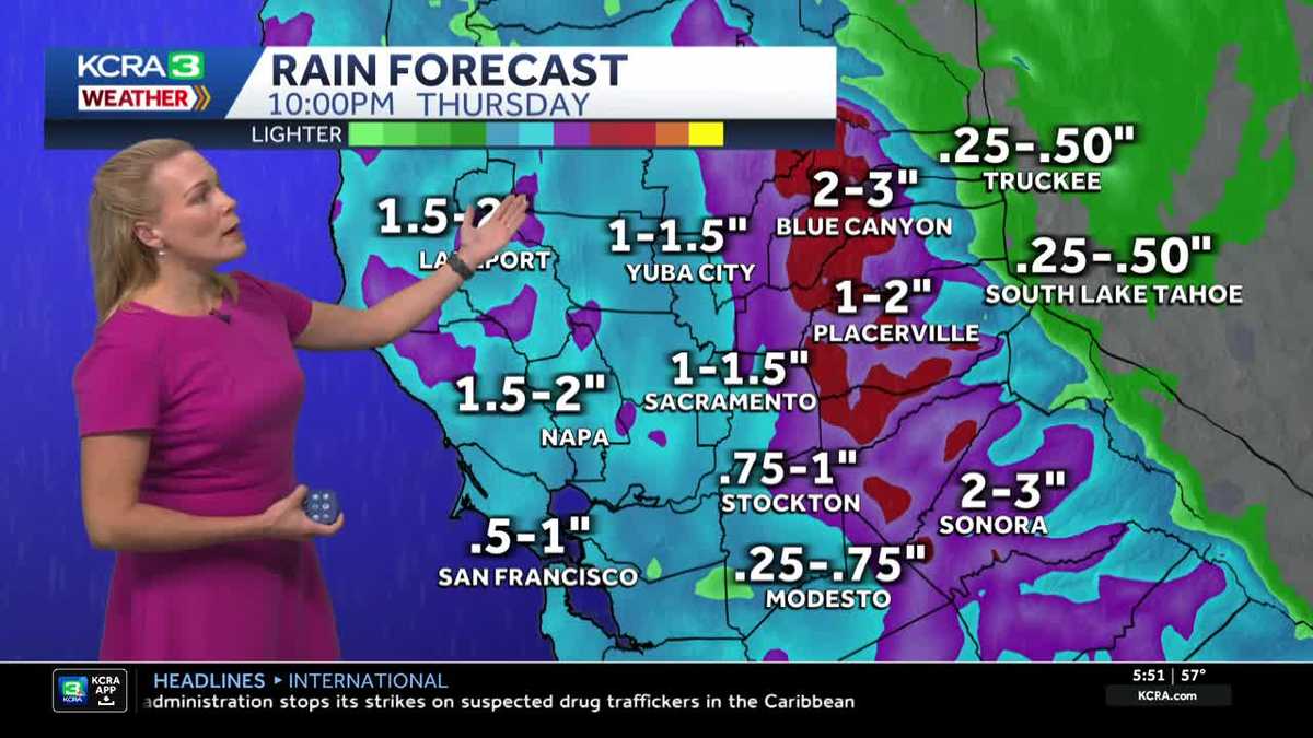
Wednesday will be dry to start and clouds will drop highs a bit from yesterday. Valley temperatures are expected to top out around 70 degrees. Highs in the foothills will be in the mid to upper 60s, with Sierra afternoon temperatures near 60 degrees.A breeze will pick up by afternoon, and increasing clouds may bring a few showers by late evening as the region prepares for a rainy Thursday.Moderate to heavy rain arrives overnight into Thursday, and commuters should prepare for a wet, gusty Thursday morning. Rain will remain steady through the day, then become lighter and more scattered in the evening, with showers lingering into Friday morning.The valley is expecting about 1 to 1.5 inches of rain in Sacramento and 0.25 to 1 inch in Stockton and Modesto. The highest amounts will be in the foothills, with areas near Blue Canyon up to 3 inches.In the Sierra, the storm will be mainly rain, with snow developing after Thursday evening above 7,000 feet into Friday morning. Only a few inches of snow are expected (4 to 8 inches).Showers gradually taper through Friday, and Saturday looks drier.
SACRAMENTO, Calif. —
Wednesday will be dry to start and clouds will drop highs a bit from yesterday.
Valley temperatures are expected to top out around 70 degrees. Highs in the foothills will be in the mid to upper 60s, with Sierra afternoon temperatures near 60 degrees.
A breeze will pick up by afternoon, and increasing clouds may bring a few showers by late evening as the region prepares for a rainy Thursday.
Moderate to heavy rain arrives overnight into Thursday, and commuters should prepare for a wet, gusty Thursday morning. Rain will remain steady through the day, then become lighter and more scattered in the evening, with showers lingering into Friday morning.
The valley is expecting about 1 to 1.5 inches of rain in Sacramento and 0.25 to 1 inch in Stockton and Modesto. The highest amounts will be in the foothills, with areas near Blue Canyon up to 3 inches.
In the Sierra, the storm will be mainly rain, with snow developing after Thursday evening above 7,000 feet into Friday morning. Only a few inches of snow are expected (4 to 8 inches).
Showers gradually taper through Friday, and Saturday looks drier.