
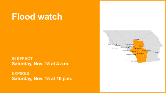
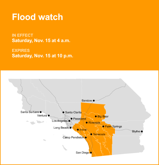
The Orange County and Santa Ana Mountains area is the focus of a flood watch issued at 11:49 a.m. on Thursday by the National Weather Service. The watch is valid for Saturday, Nov. 15 between 4 a.m. and 10 p.m.
According to the NWS San Diego CA, “Flooding caused by excessive rainfall is possible.”
“Excessive runoff may result in flooding of rivers, creeks, streams, and other low-lying and flood-prone locations, including low-water crossings. Flooding may occur in poor drainage and urban areas. There is an increased risk for debris flows near fire burn scars,” according to the NWS. “You should monitor later forecasts and be alert for possible Flood Warnings. Those living in areas prone to flooding should be prepared to take action should flooding develop.”
The full list of affected locations includes:
Santa Ana Mountains/Foothills
Orange County Coast
Orange County
San Diego County Coastal Areas
San Bernardino and Riverside County Valleys
San Diego County Inland Valleys
San Bernardino County Mountains
Riverside County Mountains
San Diego County Mountains
Apple/Lucerne Valleys
Coachella Valley
San Diego County Deserts
San Gorgonio Pass Near Banning
Deciphering advisories, watches, and warnings: Understanding weather alerts
Flash flood warning: Take action!
A flash flood warning is issued when a flash flood is imminent or occurring. If you are in a flood-prone area, move immediately to high ground. A flash flood is a sudden violent flood that can take from minutes to hours to develop. It is even possible to experience a flash flood in areas not immediately receiving rain.
Flood warning: Take action!
A flood warning is declared when flooding is on the verge of happening or is already underway.
Flood advisory: Be aware:
A flood advisory is issued when flooding is not expected to be bad enough to issue a warning. However, it may cause significant inconvenience, and if caution is not exercised, it could lead to situations that may threaten life and/or property.
Flood watch: Be prepared:
A flood watch is issued when conditions are favorable for flooding. It does not mean flooding will occur, but it is possible.
Be flood-ready: Expert guidance from the NWS for your safety
Floods can pose a significant threat, especially if you live in a flood-prone area or find yourself camping in a low-lying region. To ensure your safety, the NWS offers essential flood safety guidelines:
Seek higher ground:
If you reside in a flood-prone region or are camping in low-lying terrain, the first step to safety is relocating to higher ground.
Follow evacuation orders:
When local authorities issue an evacuation order, promptly comply. Before leaving, secure your home by locking it.
Disconnect utilities and appliances:
If time allows, disconnect your utilities and appliances. This reduces the risk of electrical hazards during flooding.
Avoid basements and submerged areas:
Avoid basements or rooms submerged in water with electrical outlets or cords. Preventing electrical accidents is crucial.
Evacuate promptly for safety:
If you notice sparks or hear buzzing, crackling, snapping, or popping noises, evacuate immediately. Avoid any water that may be charged with electricity.
Stay away from floodwaters:
Never attempt to walk through floodwaters, even if they appear shallow. Just 6 inches of fast-moving water can forcefully sweep you off your feet.
Seek higher ground when trapped:
In the event you become trapped by moving water, make your way to the highest point available and contact emergency services by calling 911.
During periods of heavy rainfall, especially in low-lying and flood-prone areas, the risk of flooding escalates. Remember this crucial advice: never attempt to drive through water on the road, even if it appears shallow. According to the NWS, as little as 12 inches of rapidly flowing water can carry away most vehicles. Stay safe by being prepared and informed.
Navigating heavy rain: Essential safety measures for wet roads
Rain can turn roads into hazards. Stay informed and follow these tips from the NWS to ensure safety during heavy rainfall:
Beware of swollen waterways:
Avoid parking or walking in close proximity to culverts or drainage ditches, as the swiftly moving water during heavy rain can potentially carry you away.
Maintain safe driving distances:
The two-second rule for following distance is your ally in heavy rain. Extend it to four seconds to ensure safe spacing in adverse conditions.
Slow down and stay cautious:
If it is raining and the roads are wet, slow down. Take your foot off the accelerator and let your speed drop gradually. Never use the brakes suddenly because this may cause the car to skid.
Choose your lane wisely:
Stick to the middle lanes to minimize the risk of hydroplaning. Outer lanes are more prone to accumulating water.
Visibility matters:
Enhance your visibility in heavy rain by turning on your headlights. Watch out for vehicles in blind spots, as rain-smeared windows can obscure them.
Watch out for slippery roads:
Be extra careful during the first half hour after rain begins. Grime and oil on the road surface mix with water to make the road slippery.
Keep a safe distance from large vehicles:
Large trucks and buses can reduce your visibility with tire spray. Avoid tailgating and pass with caution.
Mind your windshield wipers:
Overloaded wiper blades can hinder visibility. If rain severely limits your sight, pull over and wait for conditions to improve. Seek refuge at rest areas or protected spots.
If the roadside is your only option, pull off as far as possible, preferably past the end of a guard rail, and wait until the storm passes. Keep your headlights on and turn on emergency flashers to alert other drivers of your position.
In the face of heavy rain, these precautions can make a significant difference in ensuring your safety on the road. Remember to stay informed about weather conditions and heed guidance from local authorities for a secure journey.