
Northern California rain totals: How much rain fell on Thursday and what’s expected this weekend
More wet weather is expected this weekend.
UP NEAR PINE CREST AND WE STILL HAVE SOME LIGHT RAIN THERE. HOW MUCH RAIN? WELL, SOME PRETTY IMPRESSIVE NUMBERS, ESPECIALLY IN THE MOUNTAINS. BUT EVEN HERE IN THE VALLEY, WE HAD ALMOST AN INCH IN MODESTO. 8/10 OF AN INCH IN STOCKTON, ALMOST AN INCH AND A HALF IN SACRAMENTO. AND THIS IS AGAIN FROM YESTERDAY THROUGH TODAY. WE’VE HAD AUBURN 2.8, 12.62 IN PLACERVILLE ARNOLD LOOK AT THIS. OVER 4.5IN OF RAIN REPORTED THERE. LOOK AT THIS. 3.43 IN BLUE CANYON AND ABOUT ALMOST THREE AND A HALF IN QUINCY. SO AGAIN, THOSE NUMBERS ARE LOOKING PRETTY GOOD. SO HOW DO WE SIT WITH THE WATER SEASON AND THE RAIN HERE THAT WE HAVE GOING ON? SACRAMENTO SO FAR FOR THE SEASON AGAIN IS STILL SO EARLY IN THE SEASON, BUT WE’RE STARTING THINGS OFF IN A PRETTY GOOD NOTE WITH 2.35IN ON THE SEASON, AND WE’RE SITTING AT 224% OF AVERAGE STOCKTON AT 218% OF AVERAGE, MODESTO AT 1.76. IN LAKE TAHOE, PRETTY CLOSE TO AVERAGE THERE AT 104% SO FAR. AND AGAIN, WE’RE EARLY IN THE SEASON, BUT IT’S KIND OF NICE TO SEE THAT WE HAVE THESE WEATHER SYSTEMS COMING IN AND HOPEFULLY WE CAN KEEP THINGS GOING WITH SOME NICE BREAKS IN BETWEEN, OF COURSE, BUT THE AREA OF LOW PRESSURE SITTING RIGHT OFF THE COAST OF CALIFORNIA RIGHT NOW, THAT IS GOING TO BE SWINGING ACROSS THE SOUTHERN HALF OF THE STATE. AND AS IT DOES SO, IT’S GOING TO CONTINUE TO PUSH RAIN IN OUR DIRECTION. SO LET’S LOOK AT THE TIMING OF THAT. WITH THE RAIN MOVING THROUGH AGAIN, THE SHOWERS WILL BE ON THE DECREASE TONIGHT. AND LIKE I SAID WE WILL SEE SOME BREAKS IN THE CLOUD COVER. AND THAT WILL ALLOW TEMPERATURES TO DROP OFF INTO THE UPPER 40S TO LOWER 50S. CLOUDS START MOVING IN BY SATURDAY MORNING. RAIN WILL PICK UP IN THE MOUNTAINS TO THE SOUTH, BUT IT’S REALLY NOT GOING TO BE UNTIL SATURDAY EVENING THAT WE’LL SEE THAT RAIN MOVE ACROSS THE VALLEY. BUT LOOK AT THIS. IT’S GOING TO BE PUSHING A LOT OF WATER OUR DIRECTION. YOU CAN SEE IT COMING THROUGH MODESTO STOCKTON EVENTUALLY INTO SACRAMENTO AND YUBA CITY. SO COMING FROM THE SOUTH WRAPPING AROUND. AND THIS HAS GOT SOME COOLER AIR. SO WE HAVE A BETTER CHANCE OF GETTING SOME SNOW ALONG WITH THAT, ESPECIALLY AS WE GET INTO SUNDAY MORNING. SO THAT SYSTEM MOVES OUT AS WE GO THROUGH SUNDAY. THEN ANOTHER ONE ROLLS IN BY MONDAY. HERE’S MONDAY AFTERNOON. MORE RAIN IN THE FORECAST AND A LITTLE BIT OF SNOW. SO LET’S TAKE A LOOK AT HOW MUCH MORE WE’RE EXPECTING THROUGH SUNDAY AND THROUGH MONDAY. ANOTHER QUARTER OF AN INCH TO HALF AN INCH POSSIBLE. IN MODESTO AND STOCKTON WE COULD SEE UP TO THREE QUARTERS OF AN INCH IN SACRAMENTO, ABOUT A HALF AN INCH IN YUBA CITY, A LITTLE BIT MORE, OF COURSE, IN THROUGH THE MOUNTAINS, ANYWHERE FROM AN INCH TO AN INCH AND A HALF. THERE. TEMPERATURES. HERE’S A LOOK AT YOUR NUMBERS FOR TOMORROW MID TO UPPER 60S. SO AGAIN WE GET SOME BREAKS. GET A LITTLE BIT OF SUNSHINE. TEMPERATURES ARE GOING TO BE GETTING PRETTY CLOSE TO ABOUT NORMAL FOR THIS TIME OF YEAR. MID 60S IN SACRAMENTO, FAIRFIELD 67 DEGREES. AUBURN 63. IN TRUCKEE 53 DEGREES SEVEN DAY FORECAST. AND WE HAVE THAT RAIN. AND BECAUSE OF THAT RAIN, ESPECIALLY ON SUNDAY AND MONDAY, WE HAVE MORE IMPACT DAYS BECAUSE WE ARE EXPECTING MORE THAN A QUARTER OF AN INCH. AND THAT’S THE GUIDELINE THAT WE USUALLY GO TO IS IF IT’S OVER A QUARTER OF AN INCH, IT COULD HAVE AN IMPA
Northern California rain totals: How much rain fell on Thursday and what’s expected this weekend
More wet weather is expected this weekend.

Updated: 4:46 PM PST Nov 14, 2025
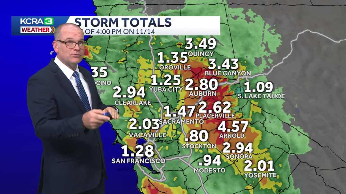
Parts of Northern California received more than 2 inches of rainfall after Thursday’s soaking. As of 4 p.m. Friday, these were the rain totals so far:Sacramento: 1.47 inchesVacaville: 2.03 inchesAuburn: 2.80 inches Placerville: 2.62 inches Modesto: 0.94 inchesStockton: 0.80 inchesSee more rain totals below. Meteorologist Tamara Berg said to expect a lot of dry time on Friday with some stray showers expected. More wet weather is expected to arrive overnight Saturday into Sunday morning. Another round is forecast for Sunday night into Monday evening. Widespread Valley rain is expected during these periods. Below are the estimated rainfall totals for Sunday-Monday. (These forecast amounts are from 4 p.m. on Nov. 14.)Sacramento: 0.25 to 0.75 inchesStockton: 0.25 to a half-inchModesto: 0.25 to a half-inchYuba City: 0.25 to a half-inchPlacerville: 1 to 1.5 inchesSonora: 1 to 1.5 inchesSouth Lake Tahoe: 0.25 to a half-inchTruckee: 0.25 to a half-inchBerg said snow levels could range between 6,000 to 7,000 feet. The weekend weather could be enough to affect travel.The KCRA 3 weather team is issuing Impact Days for Sunday and Monday because of how the rain and snow could affect outdoor activities and travel.See below for a closer look at the rain season so far in parts of Northern California. REAL-TIME TRAFFIC MAPClick here to see our interactive traffic map.TRACK INTERACTIVE, DOPPLER RADARClick here to see our interactive radar.DOWNLOAD OUR APP FOR THE LATESTHere is where you can download our app.Follow our KCRA weather team on social mediaMeteorologist Tamara Berg on Facebook and X.Meteorologist Dirk Verdoorn on FacebookMeteorologist Heather Waldman on Facebook and X.Meteorologist Kelly Curran on X.Meteorologist Ophelia Young on Facebook and X.Watch our forecasts on TV or onlineHere’s where to find our latest video forecast. You can also watch a livestream of our latest newscast here. The banner on our website turns red when we’re live.We’re also streaming on the Very Local app for Roku, Apple TV or Amazon Fire TV.See more coverage of top California stories here | Download our app | Subscribe to our morning newsletter | Find us on YouTube here and subscribe to our channel
SACRAMENTO, Calif. —
Parts of Northern California received more than 2 inches of rainfall after Thursday’s soaking.
As of 4 p.m. Friday, these were the rain totals so far:
Sacramento: 1.47 inchesVacaville: 2.03 inchesAuburn: 2.80 inches Placerville: 2.62 inches Modesto: 0.94 inchesStockton: 0.80 inches
See more rain totals below.
Meteorologist Tamara Berg said to expect a lot of dry time on Friday with some stray showers expected.
More wet weather is expected to arrive overnight Saturday into Sunday morning. Another round is forecast for Sunday night into Monday evening. Widespread Valley rain is expected during these periods.
Below are the estimated rainfall totals for Sunday-Monday. (These forecast amounts are from 4 p.m. on Nov. 14.)
Sacramento: 0.25 to 0.75 inchesStockton: 0.25 to a half-inchModesto: 0.25 to a half-inchYuba City: 0.25 to a half-inchPlacerville: 1 to 1.5 inchesSonora: 1 to 1.5 inchesSouth Lake Tahoe: 0.25 to a half-inchTruckee: 0.25 to a half-inch
Berg said snow levels could range between 6,000 to 7,000 feet. The weekend weather could be enough to affect travel.
The KCRA 3 weather team is issuing Impact Days for Sunday and Monday because of how the rain and snow could affect outdoor activities and travel.
See below for a closer look at the rain season so far in parts of Northern California.
REAL-TIME TRAFFIC MAP
Click here to see our interactive traffic map.
TRACK INTERACTIVE, DOPPLER RADAR
Click here to see our interactive radar.
DOWNLOAD OUR APP FOR THE LATEST
Here is where you can download our app.
Follow our KCRA weather team on social media
Meteorologist Tamara Berg on Facebook and X.Meteorologist Dirk Verdoorn on FacebookMeteorologist Heather Waldman on Facebook and X.Meteorologist Kelly Curran on X.Meteorologist Ophelia Young on Facebook and X.
Watch our forecasts on TV or online
Here’s where to find our latest video forecast. You can also watch a livestream of our latest newscast here. The banner on our website turns red when we’re live.
We’re also streaming on the Very Local app for Roku, Apple TV or Amazon Fire TV.
See more coverage of top California stories here | Download our app | Subscribe to our morning newsletter | Find us on YouTube here and subscribe to our channel