
A double shot of rain and snow is in the forecast this weekend into early next week as a busy weather pattern continues for Northern California. The KCRA 3 weather team is issuing Impact Days for Sunday and Monday because of how rain and snow could affect outdoor activities and travel.Two separate systems will bring precipitation chances, one coming right after the other. In both cases, most precipitation will accumulate during the overnight hours. Here is a breakdown of what to expect over the next few days. Saturday night – SundayThe same weather system that brought Thursday’s rain will bounce back toward Northern California this weekend after dumping heavy rain in Southern California. Light to moderate rain and snow will creep in from the south starting after sunset Saturday. Rainfall will be most widespread overnight Saturday into Sunday morning, but the east side of the Valley, the Foothills and the Sierra have a chance to stay soggy into the afternoon. Drier conditions are more likely west of Interstate 5 and north of Interstate 80.The snow level will be low enough for slushy accumulation in the mountains. Drivers should expect chain controls at times Saturday night into Sunday.Sunday night – MondayA new weather system will swing toward Northern California from the northwest late Sunday night. The heaviest rain will come through as a line of downpours overnight Sunday. Thunder and gusty winds are possible. Rain will change to snow above 6,000 feet as this line moves eastward before sunrise.After sunrise, steady rain will be over but scattered showers and a couple of thunderstorms will be possible in the Valley and Foothills through the afternoon.Conditions will once again be cool enough for slushy snow above 6,000 feet in the Tahoe area. Drivers should expect chain controls at times Sunday night into Monday.Two day rain and snow totalsThese two systems together will combine to produce some impressive rainfall amounts across the region. Below are estimated rainfall totals from Saturday night through Monday. These forecast amounts were current as of 7 a.m. on Saturday. Sacramento: 1.25-2 inchesStockton: 1.5-2 inchesModesto: 2-2.5 inchesYuba City: .75-1.25 inchesPlacerville: 2-3 inchesSonora: 2-3 inchesSouth Lake Tahoe: Up to a half-inchTruckee: Up to a half-inchHere are the expected snow totals between Saturday night and Monday.Donner Summit: 6-10 inchesEcho Summit: 3-6 inchesCarson Spur: 6-10 inchesEbbetts Pass: 8-12 inchesSonora Pass: 12-18 inchesAnother round of rain and snow is expected on Thursday. REAL-TIME TRAFFIC MAPClick here to see our interactive traffic map.TRACK INTERACTIVE, DOPPLER RADARClick here to see our interactive radar.DOWNLOAD OUR APP FOR THE LATESTHere is where you can download our app.Follow our KCRA weather team on social mediaMeteorologist Tamara Berg on Facebook and X.Meteorologist Dirk Verdoorn on FacebookMeteorologist Heather Waldman on Facebook and X.Meteorologist Kelly Curran on X.Meteorologist Ophelia Young on Facebook and X.Watch our forecasts on TV or onlineHere’s where to find our latest video forecast. You can also watch a livestream of our latest newscast here. The banner on our website turns red when we’re live.We’re also streaming on the Very Local app for Roku, Apple TV or Amazon Fire TV.See more coverage of top California stories here | Download our app | Subscribe to our morning newsletter | Find us on YouTube here and subscribe to our channel
A double shot of rain and snow is in the forecast this weekend into early next week as a busy weather pattern continues for Northern California.
The KCRA 3 weather team is issuing Impact Days for Sunday and Monday because of how rain and snow could affect outdoor activities and travel.
Two separate systems will bring precipitation chances, one coming right after the other. In both cases, most precipitation will accumulate during the overnight hours.
Here is a breakdown of what to expect over the next few days.
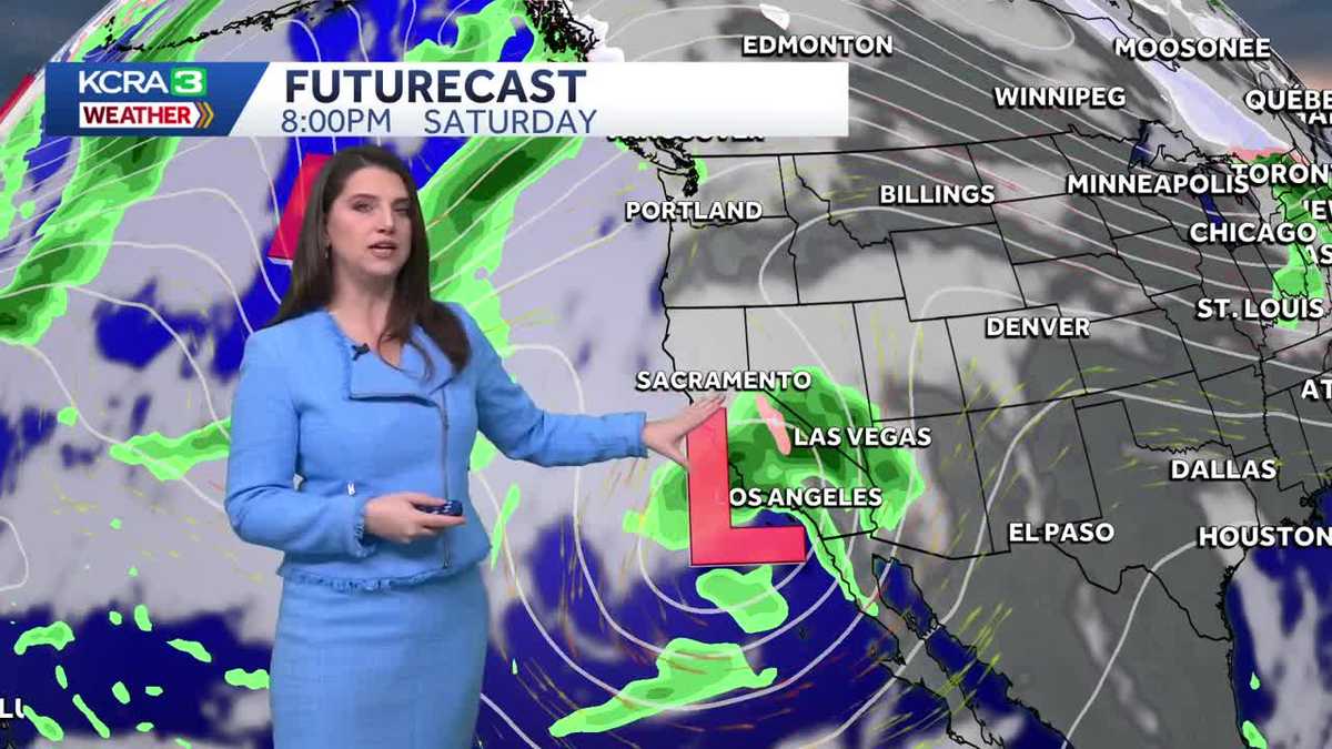
Saturday night – Sunday
The same weather system that brought Thursday’s rain will bounce back toward Northern California this weekend after dumping heavy rain in Southern California.
Light to moderate rain and snow will creep in from the south starting after sunset Saturday. Rainfall will be most widespread overnight Saturday into Sunday morning, but the east side of the Valley, the Foothills and the Sierra have a chance to stay soggy into the afternoon. Drier conditions are more likely west of Interstate 5 and north of Interstate 80.
The snow level will be low enough for slushy accumulation in the mountains. Drivers should expect chain controls at times Saturday night into Sunday.
Sunday night – Monday
A new weather system will swing toward Northern California from the northwest late Sunday night.
The heaviest rain will come through as a line of downpours overnight Sunday. Thunder and gusty winds are possible. Rain will change to snow above 6,000 feet as this line moves eastward before sunrise.
After sunrise, steady rain will be over but scattered showers and a couple of thunderstorms will be possible in the Valley and Foothills through the afternoon.
Conditions will once again be cool enough for slushy snow above 6,000 feet in the Tahoe area. Drivers should expect chain controls at times Sunday night into Monday.
Two day rain and snow totals
These two systems together will combine to produce some impressive rainfall amounts across the region. Below are estimated rainfall totals from Saturday night through Monday. These forecast amounts were current as of 7 a.m. on Saturday.

Sacramento: 1.25-2 inchesStockton: 1.5-2 inchesModesto: 2-2.5 inchesYuba City: .75-1.25 inchesPlacerville: 2-3 inchesSonora: 2-3 inchesSouth Lake Tahoe: Up to a half-inchTruckee: Up to a half-inch
Here are the expected snow totals between Saturday night and Monday.

Donner Summit: 6-10 inchesEcho Summit: 3-6 inchesCarson Spur: 6-10 inchesEbbetts Pass: 8-12 inchesSonora Pass: 12-18 inches
Another round of rain and snow is expected on Thursday.
REAL-TIME TRAFFIC MAP
Click here to see our interactive traffic map.
TRACK INTERACTIVE, DOPPLER RADAR
Click here to see our interactive radar.
DOWNLOAD OUR APP FOR THE LATEST
Here is where you can download our app.
Follow our KCRA weather team on social media
Meteorologist Tamara Berg on Facebook and X.Meteorologist Dirk Verdoorn on FacebookMeteorologist Heather Waldman on Facebook and X.Meteorologist Kelly Curran on X.Meteorologist Ophelia Young on Facebook and X.
Watch our forecasts on TV or online
Here’s where to find our latest video forecast. You can also watch a livestream of our latest newscast here. The banner on our website turns red when we’re live.
We’re also streaming on the Very Local app for Roku, Apple TV or Amazon Fire TV.
See more coverage of top California stories here | Download our app | Subscribe to our morning newsletter | Find us on YouTube here and subscribe to our channel