
California’s water year is off to a great start, thanks in large part to the past week’s stormy stretch for the state. The water year began on Oct. 1 and continues until Sept. 30 next year. Since the start of the water year, Sacramento has seen nearly 5 inches of rain at Executive Airport. That is more than three times the normal amount of rain for this point in the season. Stockton and Modesto have also more than tripled the normal rainfall through mid-November. The past few storms brought soaking rain to Northern California but then dropped south to douse Southern California, too. Those storms created flash flooding concerns this past weekend, especially in areas burned in the January fires in Los Angeles County. Los Angeles and Bakersfield have both received five times their normal rainfall through mid-November. Downtown Los Angeles’ 4.88 inches so far this season is more that one-third of the city’s normal annual rainfall. In Northern California, Eureka, Redding and Red Bluff have also seen higher than normal rain totals. December, January and February are, on average, California’s wettest months of the year.SnowStorms this month have been more wet than wintry for the state, but there has been some modest accumulation to start the season in the higher elevations. The UC Berkeley Central Sierra Snow Lab site in Soda Springs has recorded over 18 inches of snow so far this water year. That’s right in line with the normal value for mid-November. The Snow Lab sits just below 7,000 feet. Palisades Tahoe is reporting a snow depth close to one foot at 8,200 feet elevation. Carson Pass on Highway 88 has 10 inches of snow. The Department of Water Resources will begin tracking statewide snowpack water content in December. Snowpack water content typically reaches its peak between the last week of March and the first week of April. Snowmelt accounts for up to one-third of California’s drinking water each year. So while big rain totals are good to see, big snow numbers are what guarantee a healthy water supply going into next summer.See more coverage of top California stories here | Download our app | Subscribe to our morning newsletter | Find us on YouTube here and subscribe to our channel
SACRAMENTO, Calif. —
California’s water year is off to a great start, thanks in large part to the past week’s stormy stretch for the state.
The water year began on Oct. 1 and continues until Sept. 30 next year.
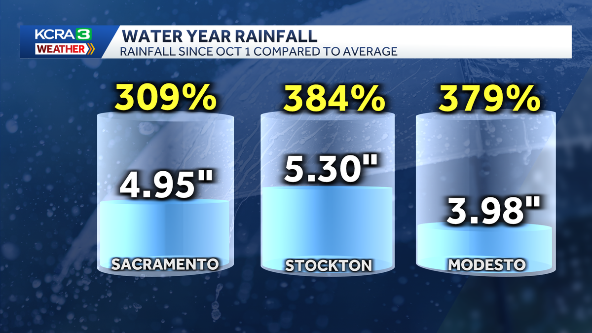
Since the start of the water year, Sacramento has seen nearly 5 inches of rain at Executive Airport. That is more than three times the normal amount of rain for this point in the season.
Stockton and Modesto have also more than tripled the normal rainfall through mid-November.

Hearst Owned
Sacramento, Stockton and Modesto have each measured more than three times their normal rainfall through mid November.
The past few storms brought soaking rain to Northern California but then dropped south to douse Southern California, too. Those storms created flash flooding concerns this past weekend, especially in areas burned in the January fires in Los Angeles County.
Los Angeles and Bakersfield have both received five times their normal rainfall through mid-November. Downtown Los Angeles’ 4.88 inches so far this season is more that one-third of the city’s normal annual rainfall.

Hearst Owned
Some cities in Southern California have seen five times their normal rainfall for this point in the water year.
In Northern California, Eureka, Redding and Red Bluff have also seen higher than normal rain totals.
December, January and February are, on average, California’s wettest months of the year.
Snow
Storms this month have been more wet than wintry for the state, but there has been some modest accumulation to start the season in the higher elevations.
The UC Berkeley Central Sierra Snow Lab site in Soda Springs has recorded over 18 inches of snow so far this water year. That’s right in line with the normal value for mid-November. The Snow Lab sits just below 7,000 feet.

Hearst Owned
The UC Berkeley Central Sierra Snow Lab has measured about a foot and a half of snow so far this season. That’s right around average for mid-November.
Palisades Tahoe is reporting a snow depth close to one foot at 8,200 feet elevation. Carson Pass on Highway 88 has 10 inches of snow.

Hearst Owned
There hasn’t been much snow yet this season, but some of the higher elevations have seen some modest accumulation.
The Department of Water Resources will begin tracking statewide snowpack water content in December. Snowpack water content typically reaches its peak between the last week of March and the first week of April.
Snowmelt accounts for up to one-third of California’s drinking water each year. So while big rain totals are good to see, big snow numbers are what guarantee a healthy water supply going into next summer.
See more coverage of top California stories here | Download our app | Subscribe to our morning newsletter | Find us on YouTube here and subscribe to our channel