
SAN DIEGO (FOX 5/KUSI) — Scattered showers persist across San Diego County on Sunday night as the first atmospheric river of the season moves east, but immediately following it, a new storm brings more chances of rain and even snow to the county.
Record rainfall fell across the county with totals surpassing as much as 2-inches in a 24-hour period. View the three-day precipitation totals on the National Weather Service’s website at forecast.weather.gov.
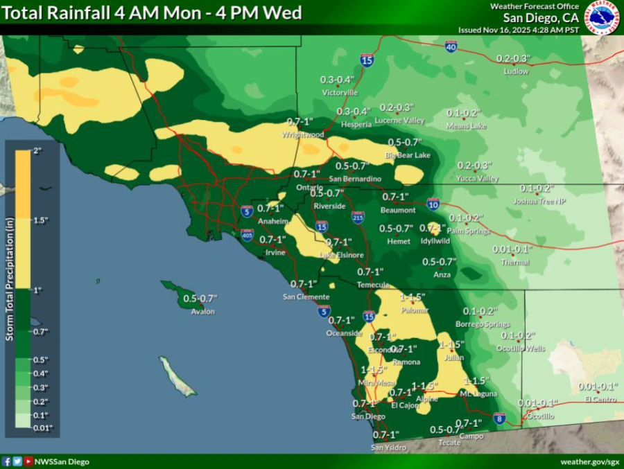
Rainfall totals across San Diego County
Light scattered showers stick around through Monday morning. The heaviest rainfall will begin on Monday afternoon and become more widespread through the evening.
Over the next three days, this storm could add an additional 0.7 to 1 inch of rain to the coast and inland valleys and as much as 1 to 1.5 inches of rain to the mountain regions.

A second storm is forecast to bring more widespread precipitation Monday afternoon through Wednesday (PHOTO: National Weather Service)
Gusty winds persist in the mountains with winds up to 20 to 35 miles per hour in eastern San Diego County.
A cooling trend lingers through the beginning of the week with highs between 5 to 7 degrees below average for this time of year in the coastal and desert regions and as much as 10 to 20 degrees below normal in the valleys and mountains.
Snow levels will drop on Tuesday to 5000 feet, ushering in chances for 1 to 3 inches of snowfall in Mount Laguna.
Full forecast at fox5sandiego.com/weather
Copyright 2025 Nexstar Media, Inc. All rights reserved. This material may not be published, broadcast, rewritten, or redistributed.
For the latest news, weather, sports, and streaming video, head to FOX 5 San Diego & KUSI News.