
Amid criticism by businesses and property owners, the Sausalito City Council has sent a sea level strategy plan back for more work.
The council received the shoreline adaptation plan at its meeting on Tuesday but deemed it incomplete. The 168-page plan, addressing the forecast of rising waters in coming decades, detailed a menu of remedies that presumed pulling back from the current shoreline.
Opponents said that could threaten their livelihoods.
“After reviewing these options, I need to clearly say if any of these move forward, the maritime industry in Sausalito will not survive,” said K.C. Pederson, Clipper Yacht Harbor vice president. “Maritime uses are not optional amenities.”
“The plan repeatedly recommends live with water strategies, even floating or adaptive floating structures — ideas that look creative on paper but are not realistically or economically viable,” said Jim Madden, whose family built Sausalito Yacht Harbor. “What’s missing from this plan is the simplest and most reliable approach to preserve and reinforce the existing shoreline.”
“I’m here to ask you to not accept it as a plan,” said Tim Rogers of the Sausalito Sustainable Waterfront Association, a recently formed business group. “You’ve heard from a half-dozen gentlemen who have nearly four centuries of family and are invested in this community, in this waterfront.”
The council instructed staff to add analyses of economic impacts, include costs for specific remedies that preserve the shoreline, explore financing that doesn’t involve local taxes and more directly involve waterfront stakeholders in those assessments.
“There’s a whole lot of good work there,” Vice Mayor Steven Woodside said of the plan, while also endorsing the redirection. “You may not agree with every aspect of it. But let’s look at various aspects.”
“Some of the alternatives that are very unacceptable to the marinas, for example, tells us that if we don’t carefully understand what sea level rise and climate change will do to Richardson Bay, we may wind up inundated unless we have a good solution,” he said. “That’s the reality. … It’s hard to predict but we need a more tailored approach to our shoreline and our bay.”
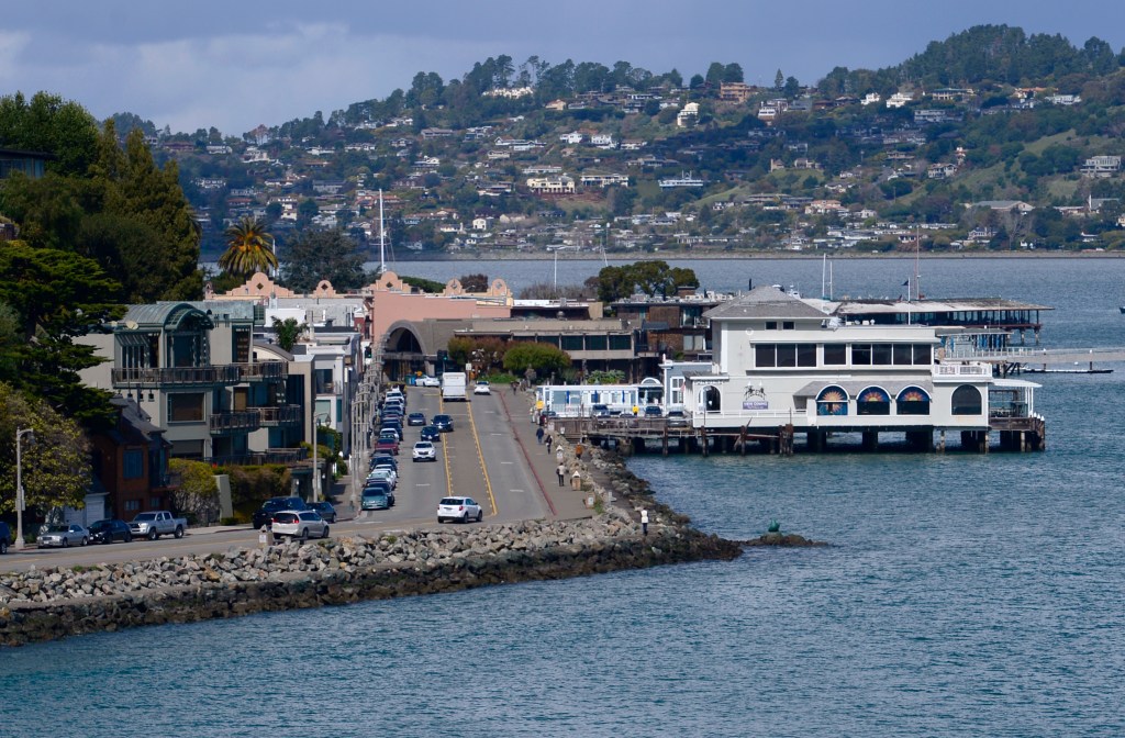
The shoreline adaptation plan was two years in the making and detailed a range of near- and long-term responses along five sections of Richardson Bay.
In 2021, the city created a sea level rise committee that produced a report that led to a $1 million state grant to develop the shoreline adaptation plan. About half of the funds were spent on consultants in the past two years to create the document presented Tuesday.
The plan, relying on state data, projects that Richardson Bay will be 10 inches higher by 2050 and 4.3 feet higher during king tides and storms. By 2100, bay levels will be 3.1 feet higher and reach 6.6 feet in storms and surges. At the same time, stretches of city bayfront will sink, which is already happening in the Marinship area. These dynamics compound the challenges facing public and private infrastructure, buildings and uses.
Under the direction given to the city’s consultants, the shoreline plan was to identify adaptation strategies. Those include elevated buildings and roads, floating piers, living breakwaters and “resilient edges” such as berms, levees and sea walls. The plan assessed vulnerabilities and cited remedies in five zones: the southern waterfront from Swede’s Beach to the Bridgeway boardwalk; the ferry terminal and historic district; New Town, which lies between the Spinnaker restaurant and Galilee Harbor; the Marinship former industrial shipyard; and the floating homes zone opposite Marin City.
The project scope required a team of consultants led by WRT Design to engage with stakeholders. Focus groups, community workshops and other outreach efforts ensued, said John Gibbs of WRT.
“There were a number of property owners, business owners, in the waterfront area,” he said. “And again, those meetings were held in the early stages of the plan.”
But the scope did not specify preserving the current shoreline, city officials said. At the time, the City Council was also looking at its options for more housing and rejected parcels near the bayfront. The absence of direction to preserve the bayfront, as well as businesspeople more recently feeling they were not sufficiently consulted, contributed to the frictions that surfaced on Tuesday.
During public comments, nonetheless, a handful of people praised the shoreline adaptation plan.
“There are many criticisms of this plan, but I am here to thank you,” said Caroline Revell of Sausalito Beautiful, who said the plan is educational and highlights the importance of the issue.
“I worked on your sea level rise task force,” said Terry Thomas, an ecologist who lives in a floating home. “Don’t throw out this incredible piece of work that’s just an approach to how you can plan. Take it and then you can go to all the property owners, work with all the small groups and find out exactly what we can do in our backyard.”
During the council discussion, it became apparent that the plan needed to be broadened.
Jill Hoffman, the former mayor who formed the sea level committee, noted the city has until 2034 to file its plan with regional authorities. She said the current plan is incomplete and that WRT should reach out to commercial stakeholders to fill in the gaps.
Hoffman also said the consultants should have more frequently briefed the council and sought guidance. If accepted as is, the plan would become a “reference point” that would send the wrong message to other cities and towns, she said.
“Do we believe that we want to give up all of our businesses along our shoreline to floating concepts and give up our working waterfront?” she said. “I completely believe K.C. Pederson’s point that if we accept this plan, and accept the facts of this plan as presented, that we are going to lose our working waterfront.”
“It implies that most of the working waterfront is not going to be operable as it is today,” said Councilmember Melissa Blaustein. “A big concern for those of us on the dais, and in the city generally who rely on the tax income, is how do we continue those businesses?”
Mayor Joan Cox said the plan struck the wrong notes by suggesting that Sausalito landmarks like the Spinnaker restaurant could be moved and the underlying land restored as a tidal flat.
Cox worried that WRT no longer had the trust of those stakeholders and suggested it might be best to rely on other experts to develop the plan’s additional economic, engineering and financial elements. She said the suggestion by Marinship property owner Carlo Berg to explore creating a special infrastructure revenue district could be one way to obtain funds that do not rely on raising local taxes.
Several council members noted that the city still has about half of the $1 million state grant that could be used to develop other areas of the plan.
Councilmember Ian Sobieski noted the plan has many important elements that could be built upon and proposed the motion that the plan be received by the council but not accepted as complete. The motion also directed staff to “come back with a proposal” to use the remaining grant funds and “engagement on a solution … (that) should involve a tightly coupled interaction with property and business owners with long history on the waterfront.”
The motion passed unanimously. Cox further instructed the city manager to meet with the consulting team to determine next steps.