
Northern California forecast: Sunday morning fog will clear for a nice Fall day
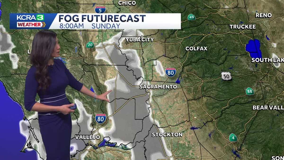
Some in the valley and parts of the Tahoe Basin will wake up to dense fog, which should lift by late morning.
KNOWING THAT WE GOT THAT RAIN OUT OF THE WAY, RIGHT? WE’RE LOOKING AT THE STATE CAPITOL RIGHT NOW WHERE THE FLAG IS BARELY EVEN MOVING. THE WINDS ARE SO CALM. TEMPERATURES IN THE MID 50S. SO IT IS COOL STEPPING OUT EVEN COOLER IN THE FOOTHILLS THERE AT 50 DEGREES AND IN THE SIERRA, FALLING QUICKLY INTO THE 30S. WHERE’S OUR WEATHER SYSTEM FROM? EARLIER THIS WEEK? WELL, IT’S STALLED OVER THE DESERT SOUTHWEST. WE GOT SOME RAIN THAT PASSED LAS VEGAS. IT’S IN NEW. IT’S IN ARIZONA NOW. WE HAVE AN AREA OF HIGH PRESSURE THAT CONTINUES TO WEDGE ITSELF IN, AND THAT’S GOING TO GRANT US SOME NICE WEATHER FOR THE REST OF THIS WEEKEND. AND PRETTY MUCH ALL OF NEXT WEEK. GOT A POCKET OF DRY AIR UNDERNEATH THAT RIDGE. AND WE EVEN HAVE CLEAR SKIES THAT WE’RE GOING TO HAVE OVERNIGHT BECAUSE OF THAT LITTLE RADIATIONAL COOLING WILL LEAD TO DENSE FOG. DENSE FOG ADVISORY HAS BEEN ISSUED BY THE NATIONAL WEATHER SERVICE AS WE WAKE UP TOMORROW MORNING, WE COULD HAVE AREAS OF POOR VISIBILITY A QUARTER MILE OR LESS. SO WE WANT TO BE CAREFUL DRIVING AROUND YOUR SUNDAY MORNING, THAT FOG WILL BEGIN IN THE WEST SIDE OF THE VALLEY. IT LOOKS LIKE IT’S GOING TO SPREAD EAST, BUT MAINLY REMAIN IN THE WEST SIDE OF THE SACRAMENTO VALLEY. AND THEN IT WILL CLEAR BY 10:00 11:00. THEN WE’LL FIND OURSELVES ANOTHER FALL AFTERNOON WITH TEMPERATURES IN THE LOW 50S IN THE SIERRA. WE HAVE MID 50S IN POLLOCK PINES ARNOLD, YOSEMITE, LOOKING AT HIGHS NEAR 60 DEGREES. TOMORROW. NICE SUNNY DAY IN THE FOOTHILLS, A LITTLE BIT WARMER WITH TEMPERATURES IN THE UPPER 50S AND PLACERVILLE AND AUBURN, JACKSON AND ANGELS CAMP WARMING TO LOW 60S. NICE DAY IN THE DELTA IN THE BAY AREA WITH A LITTLE OFFSHORE FLOW. 60 DEGREES IN SAN FRANCISCO, A LITTLE WARMER IN CONCORD WITH HIGHS NEAR 62. ALSO FINDING 62. IN LAKEPORT IN THE SAN JOAQUIN VALLEY, WE’RE LOOKING FOR LOW 60S AS WELL. WE HAVE UPPER 50S IN MODESTO AND TURLOCK WITH JUST A FEW CLOUDS, AND IN THE SACRAMENTO VALLEY. AFTER THAT, FOG CLEARS, WE’LL HAVE MOSTLY, MOSTLY SUNNY SKIES IN THE AFTERNOON WITH TEMPERATURES IN MOST SPOTS CLIMBING TO LOW 60S, A LITTLE COOLER IN DAVIS AND ELK GROVE WITH HIGHS JUST UNDER 60 DEGREES. HIGH PRESSURE ACTUALLY STICKS AROUND FOR MUCH OF NEXT WEEK. WE DO HAVE A FEW PASSING WEATHER SYSTEMS TO THE NORTH. MIGHT GET SOME CLOUDS HERE AND THERE EACH DAY, BUT ON THANKSGIVING, THAT HIGH PRESSURE STICKS AROUND. IT DOES FLATTEN A LITTLE BIT, WHICH DOES MEAN TEMPERATURES MIGHT REMAIN RIGHT AROUND THE 60 DEGREE MARK. BUT ASIDE FROM A FEW CLOUDS, THANKSGIVING LOOKING FANTASTIC. 65 IF YOU’RE HEADED OUT TO THE COAST IN THE VALLEY 62 DEGREES THE FOOTHILLS LOOKING AT 60 ON TURKEY DAY, WITH THE SIERRA TOPPING OUT WITH HIGHS NEAR 56 DEGREES. SO LOOKING OUT TO YOUR NEXT SEVEN DAYS, IT IS A REALLY NICE ONE. YOU GUYS. WE HAVE LOW 60S PRETTY MUCH EVERY DAY. SATURDAY, HOWEVER, I’M WATCHING A WEATHER SYSTEM THAT WILL SWING THROUGH. TEMPERATURES MIGHT BE A LITTLE COOLER FOR US. WE’LL GET SOM
Northern California forecast: Sunday morning fog will clear for a nice Fall day
Some in the valley and parts of the Tahoe Basin will wake up to dense fog, which should lift by late morning.

Updated: 7:01 PM PST Nov 22, 2025
Some in the valley and parts of the Tahoe Basin will wake up to dense fog, which should lift by late morning.By noon, expect mostly sunny skies, with temperatures headed toward highs near 60 in the valley, upper 50s in the foothills, and low 50s in the Sierra. Winds will be light and variable.This pattern will essentially repeat each day next week as high pressure remains dominant. Systems passing to our north will bring a few high clouds each day after the morning fog clears. Highs on Thanksgiving will be in the low 60s under mostly sunny skies with light winds.Thanksgiving in the foothills will be pleasant, with highs in the low 60s; the Sierra will be in the mid-50s with a light breeze.Friday looks mild as well, but an approaching system will bring increasing cloud cover. The area of low pressure is forecast to move inland to our north before dropping south, which means changing weather may arrive Saturday, with increasing winds and a chance of Sierra snow Saturday and Sunday.There is still considerable uncertainty about next weekend’s weather, so travelers should keep a close eye on the forecast.
SACRAMENTO, Calif. —
Some in the valley and parts of the Tahoe Basin will wake up to dense fog, which should lift by late morning.
By noon, expect mostly sunny skies, with temperatures headed toward highs near 60 in the valley, upper 50s in the foothills, and low 50s in the Sierra. Winds will be light and variable.
This pattern will essentially repeat each day next week as high pressure remains dominant. Systems passing to our north will bring a few high clouds each day after the morning fog clears. Highs on Thanksgiving will be in the low 60s under mostly sunny skies with light winds.
Thanksgiving in the foothills will be pleasant, with highs in the low 60s; the Sierra will be in the mid-50s with a light breeze.
Friday looks mild as well, but an approaching system will bring increasing cloud cover. The area of low pressure is forecast to move inland to our north before dropping south, which means changing weather may arrive Saturday, with increasing winds and a chance of Sierra snow Saturday and Sunday.
There is still considerable uncertainty about next weekend’s weather, so travelers should keep a close eye on the forecast.