
NorCal forecast: Stubborn fog, clouds keeps the Valley cool
Areas below 500′ elevation will be socked in with gray skies most of the time for a few more days.
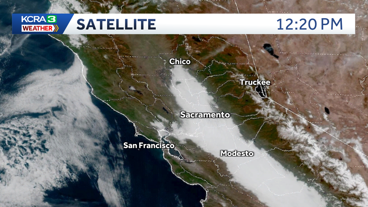
ALL RIGHT. KCRA 3 WEATHER NOW AND A LIVE LOOK AT STOCKTON AND LOOK AT THAT. THE FLAG GOING JUST A LITTLE BIT. BUT IT’S IT’S BEEN GRAY AND FOGGY OUT THERE FOR MUCH OF THE VALLEY. LET’S GET THE DIRK WITH OUR FORECAST. I’M GRATEFUL THAT LISA HAS A LOT OF PATIENCE. SO ARE OUR BOSSES. ALL RIGHT, HERE WE GO. WE’VE GOT WE’VE GOT SOME LOW CLOUDS. THE CLOUDS. THIS IS THE FOG, ACTUALLY, THAT’S SET UP IN THE VALLEY RIGHT NOW. AND IT’S TRYING TO BREAK OUT. THE SUN IS TRYING TO BURN IT OFF AND GIVE US A LITTLE BIT OF SUN BEFORE IT GOES DOWN. AND THAT LOOKS LIKE IT MAY BE THE CASE. AND SO THAT’S GOING TO HELP TO KEEP OUR TEMPERATURES IN THE 50S IN MANY SPOTS. TEMPERATURES ALREADY GOING DOWN SACRAMENTO IS 50 DEGREES 53 IN STOCKTON, 52 IN MODESTO AND 44 DEGREES AT LAKE TAHOE. WE MAY HAVE MADE IT INTO THE MID 50S IN SOME SPOTS, BUT WHEN WE GET THAT VALLEY FOG THAT SETS UP, IT JUST DOES NOT WARM UP. AND THAT’S THE CASE. AND THE REASON WHY IS WE HAVE THIS RIDGE OF HIGH PRESSURE THAT’S SITTING RIGHT OFF THE COAST OF CALIFORNIA. THIS IS STILL MOVING INTO CALIFORNIA. AND SO AS LONG AS THIS IS AROUND, WE’RE NOT GOING TO SEE MUCH IN THE WAY OF WIND. AND WE’VE GOT THAT COLD, DAMP AIR THAT’S CAUGHT, KIND OF TRAPPED HERE IN THE CENTRAL VALLEY. AND AS LONG AS THAT STICKS AROUND, WE’RE NOT GOING TO BE SEEING MUCH SUNSHINE, SUNSHINE. SO FUTURECAST SHOWING US THIS IS GOING TO REDEVELOP OVERNIGHT TONIGHT. NOW AS IT STARTS TO REDEVELOP ESPECIALLY THROUGH THE SACRAMENTO VALLEY, WE’RE GOING TO SEE THE THICKER FOG. AND SO YOU WILL HAVE GROUND FOG THAT’S GOING TO LIMIT VISIBILITY. SO BE AWARE OF THAT CHANCE ALSO ALONG THE EDGES AND ALONG THE VALLEY THE WEST SIDE AND THE EAST SIDE, YOU’RE GOING TO BE RUNNING INTO THE THICKER FOG. BUT IF YOU’RE IN THE CENTER OF THE VALLEY IT’S MOSTLY JUST THE LOW CLOUD COVER THAT YOU’RE GOING TO BE DEALING WITH ALL NIGHT LONG. AND THEN MOST OF TOMORROW, TOO. SO AS WE GET INTO TOMORROW AFTERNOON, WE’RE STILL GOING TO HAVE THE FOG OUT THERE. AND YOU CAN SEE IT BREAKS UP IN SOME SPOTS, BUT IT’S STILL GOING TO BE LINGERING. THEN IT FILLS RIGHT BACK IN AGAIN THROUGH TUESDAY AFTERNOON AND ON INTO WEDNESDAY MORNING. STILL NICE AND THICK. AND THEN IT LOOKS LIKE IT’S GOING TO STICK AROUND ALL THE WAY THROUGH THURSDAY BEFORE WE SEE SOME CLOUDS THAT MAY HELP TO BREAK IT UP AS WE GET INTO THURSDAY AFTERNOON. SO DENSE FOG ADVISORY IS UP AND THIS IS UP FROM 11 A.M. FROM MIDNIGHT TONIGHT TO 11 A.M. TOMORROW MORNING. WIDESPREAD DENSE FOG, VISIBILITY AGAIN IN SOME AREAS. WE’RE GOING TO HAVE SOME OF THAT THICKER FOG. SO MAKE SURE YOU GIVE YOURSELF SOME EXTRA TIME AND SLOW DOWN. MAKE SURE YOU USE YOUR LOW BEAMS AND JUST MAKE SURE THAT YOU’RE AWARE OF WHERE YOU’RE DRIVING, WHERE YOU WANT TO GO. SO SIERRA FORECAST THIS IS FOR TOMORROW. WE’RE LOOKING AT LOTS OF SUNSHINE FOR TRUCKEE AND LAKE TAHOE TEMPERATURES WARMING INTO THE MID 50S. AFTER A COOL START WITH TEMPERATURES IN THE LOW 20S IN THE MORNING FOR THE FOOTHILLS. ALSO, THERE MAY BE SOME FOG YOU’RE GOING TO BE DEALING WITH EARLIER IN THE MORNING, AND THEN IT SHOULD START TO LIFT SOMEWHAT, AND THEN YOU’LL GET THE SUNSHINE AND HAVE TEMPERATURES WARMING INTO THE UPPER 50S, CLOSE TO 60 DEGREES. BAY AREA ALSO LOOKING PRETTY GOOD. 63 IN SAN FRANCISCO, 66 IN SAN JOSE, FAIRFIELD ALSO EXPECT TO GET A LITTLE BIT OF SUNSHINE IN THE AFTERNOON, BUT YOU’LL HAVE THAT LOW CLOUD COVER IN THE FOG IN THE MORNING. 56 IN STOCKTON MANTECA 56 DEGREES AND IT MAY STAY OVERCAST ALL DAY LONG. YOU MAY GET A LITTLE BIT OF HAZY SUNSHINE, BUT THAT’S ABOUT IT. AND I WILL SEE THAT ALSO THROUGH A GOOD PORTION OF THE SOUTHERN SACRAMENTO VALLEY. VACAVILLE MAY GET A LITTLE SUNSHINE. SO WARMING UP INTO THE 60S, BUT MOST SPOTS WE’RE TALKING MID 50S FOR DAYTIME HIGHS. AND THEN WE HAVE THE TEMPERATURES THAT ARE GOING TO STAY COOL WITH THAT CHANCE FOR MORE FOG THROUGH WEDNESDAY, THURSDAY FOR THANKSGIVING. I STILL THINK IT’S GOING TO BE STICKING AROUND. AND THEN WE HAVE IT STARTING TO BREAK UP BY FRIDAY AND SATURDAY, AND WE COULD EVEN SEE A LITTLE BIT OF RAIN ON SATURDAY. I’LL HAVE MORE ON THA
Meteorologist/Climate Reporter
Low clouds and fog will keep the Sacramento and San Joaquin Valley in the gray for the next few days, including Thanksgiving. Meanwhile the Foothills and Sierra will see plenty of sunshine Tuesday and Wednesday with increasing higher altitude clouds on Thanksgiving Day. Another Dense Fog Advisory is in effect for the entire Central Valley from midnight to 11 a.m. Tuesday. Drivers should expect changing visibility conditions with some areas seeing visibility drop below 400 feet. Valley temperatures will be in the upper 40s Tuesday and Wednesday mornings. Cloud cover will cap high temperatures in the upper 50s. The Foothills will be much brighter and could end up a couple degrees warmer as a result. Sierra travel will be easy this week with dry conditions through Friday. A weak weather system will drop south on the east side of the Sierra this weekend. There is a chance for some light rain and mountains snow late Saturday into early Sunday.
Low clouds and fog will keep the Sacramento and San Joaquin Valley in the gray for the next few days, including Thanksgiving.
Meanwhile the Foothills and Sierra will see plenty of sunshine Tuesday and Wednesday with increasing higher altitude clouds on Thanksgiving Day.
Another Dense Fog Advisory is in effect for the entire Central Valley from midnight to 11 a.m. Tuesday. Drivers should expect changing visibility conditions with some areas seeing visibility drop below 400 feet.
Valley temperatures will be in the upper 40s Tuesday and Wednesday mornings. Cloud cover will cap high temperatures in the upper 50s. The Foothills will be much brighter and could end up a couple degrees warmer as a result.
Sierra travel will be easy this week with dry conditions through Friday.
A weak weather system will drop south on the east side of the Sierra this weekend. There is a chance for some light rain and mountains snow late Saturday into early Sunday.